Location
Latitude: |
46-13-05.8000N (46.218278) |
Longitude: |
097-38-36.1000W (-97.643361) |
Elevation: |
1265.5 feet MSL (386 m MSL) |
Magnetic Variation: |
3.3 E (as of April 2024 from WMM2020 model) |
Time Zone: |
UTC -6.0 (Standard Time) UTC -5.0 (Daylight Savings Time) |
From City: |
01 N.M. SE of Gwinner, North Dakota |
Found On: |
Twin Cities Chart |
FAA Region: |
AGL |
Contacts
Manager: |
Publicly owned: |
| RICK HOISTAD BOX 221 FORMAN, ND 58032 701-680-8000 |
GWINNER ARPT AUTH 400 4TH AVE SE GWINNER, ND 58040 701-680-8000 |
Operations
Airport Status: |
Operational |
Facility Use: |
Public |
Type: |
Airport |
Control tower: |
No |
Attendance (Months/Days/Hours): |
Months/Days/Hours Unattended |
Boundary ARTCC: |
ZMP (Minneapolis) |
Responsible ARTCC: |
ZMP (Minneapolis) |
Lighting Schedule: |
SEE RMK |
Segmented Circle Indicator: |
No |
Traffic Pattern Altitude (MSL): |
2266 feet (691 m) |
NOTAMs Facility: |
GFK |
NOTAM-D Service: |
Yes |
International Airport of Entry: |
No |
Customs Landing Rights: |
No |
Military Landing Rights: |
Yes |
Civil/Military Joint Use: |
No |
Based Aircraft
| Single Engine: | 9 |
| Multi Engine: | 2 |
Annual Operations (as of 09/07/2023)
| Total Operations: | 5620 | |
| Air Taxi: | 600 | 10.7% |
| GA Local: | 3000 | 53.4% |
| GA Itinerant: | 2000 | 35.6% |
| Military Aircraft: | 20 | 0.4% |
Communications
| CTAF: | 122.700 |
| Unicom: | 122.700 |
| AWOS-3: | 118.325 (701-678-6801) |
- APCH/DEP SVC PRVDD BY MINNEAPOLIS ARTCC ON FREQS 127.35/278.3 (FARGO RCAG).
Fixed Based Operators (FBOs) & Fuel
(Click on a business for detail)
Please help us keep this information up to date. This is a FREE SERVICE just like everything else on Airport Guide! If you see that a business needs to be added, modified, or deleted please fill out our Update Form.
To add, modify, or delete a business click here.
Please help us keep this information up to date. This is a FREE SERVICE just like everything else on Airport Guide! If you see that a business needs to be added, modified, or deleted please fill out our Update Form.
Area Code: 701 |
| Business Name | Frequency | Phone | Fuel Grade |
|---|
Flight Service Stations
| Primary | Alternate | |
| FSS on Field: | N | |
| FSS Name (ID): | Grand Forks(GFK) | |
| Frequency: | ||
| Toll Free Phone: | 1-800-WX-BRIEF |
Instrument Procedures / Charts
FAA Terminal Procedures valid from 0901Z 03/21/24 to 0901Z 04/18/24.
There are various types of charts available for an airport. They are listed in the Page Type column. Here is a legend for those types:
APD - Airport Diagram
DP - Departure Procedure Charts
HOT - Hot Spots
IAP - Instrument Approach Procedure Charts
MIN - Minimums
STAR - Standard Terminal Arrival Charts
| Page Type | Page Name | Volume | Action Since Last Cycle |
|---|---|---|---|
| IAP | RNAV (GPS) RWY 16 | NC-1 | |
| IAP | RNAV (GPS) RWY 34 | NC-1 | |
| MIN | ALTERNATE MINIMUMS | NC-1 | |
| MIN | TAKEOFF MINIMUMS | NC-1 |
Terminal Procedures are only available for airports in several countries with more being added all the time. If you are looking for a specific country's charts, please send an email to support(at)airportguide.com stating the country name. This will be used to prioritize the implementation.
Navigation Aids (Navaids) near GWR
| Dist (NM) | ID | Morse Code | Name | Type | Freq | True Hdg | Mag Hdg |
|---|---|---|---|---|---|---|---|
| 0.3 | GWR | _ _ . . _ _ . _ . | Gwinner | NDB | 278 | 5 | 2 |
| 43.2 | BWP | _ . . . . _ _ . _ _ . | Breckenridge-Wahpeton | NDB | 233 | 87 | 84 |
| 45.8 | FAR | . . _ . . _ . _ . | Fargo | VOR-DME | 116.20 | 45 | 42 |
| 52.6 | ETH | . _ . . . . | Wheaton | NDB | 326 | 119 | 116 |
| 54.7 | JM | . _ _ _ _ _ | Sabon | NDB | 395 | 315 | 311 |
| 56.8 | ABR | . _ _ . . . . _ . | Aberdeen | VOR-DME | 113.00 | 212 | 208 |
| 57.6 | AB | . _ _ . . . | Reney | NDB | 203 | 210 | 206 |
| 58.4 | AA | . _ . _ | Kenie | NDB | 365 | 35 | 32 |
| 60.5 | JMS | . _ _ _ _ _ . . . | Jamestown | VOR-DME | 114.50 | 315 | 311 |
| 61.8 | FFM | . . _ . . . _ . _ _ | Fergus Falls | VOR-DME | 110.40 | 85 | 82 |
| 65.8 | FF | . . _ . . . _ . | Hamre | NDB | 337 | 89 | 86 |
| 75.1 | VVV | . . . _ . . . _ . . . _ | Ortonville | NDB | 332 | 136 | 133 |
| 77.2 | ATY | . _ _ _ . _ _ | Watertown | TACAN | 116.60 | 163 | 160 |
| 80.1 | MOX | _ _ _ _ _ _ . . _ | Morris | VOR-DME | 109.60 | 118 | 115 |
| 81.1 | DTL | _ . . _ . _ . . | Detroit Lakes | VOR-DME | 111.20 | 62 | 59 |
| 87.4 | AT | . _ _ | Lican | NDB | 215 | 166 | 163 |
| 90.6 | AQP | . _ _ _ . _ . _ _ . | Appleton | NDB | 356 | 130 | 127 |
| 96.2 | DXX | _ . . _ . . _ _ . . _ | Dawson/Madison | NDB | 341 | 139 | 136 |
| 99.0 | BBB | _ . . . _ . . . _ . . . | Benson | NDB | 239 | 121 | 118 |
| 99.5 | GF | _ _ . . . _ . | Hiser | NDB | 345 | 10 | 7 |
Nearby Airports with Fuel
Notices to Airmen (NOTAMS)
Remarks
| A11 | ADDITIONAL CONTACT GROVER RIEBE 701-680-0605 |
| A110-1 | RY 06/24 CLSD WINTER MONTHS. |
| A110-5 | CFM WINTER CONDS & RWY 16/34 SN REMOVAL CALL 701-680-8000; 701-308-0169;CITY MAINT 701-680-0081. |
| A110-6 | RY 16 +480 FT LGTD TOWER 17500 FT FM THLD 3000 FT R OF EXTDD CNTRLN. |
| A110-7 | DEER & BIRDS ON & INVOF ARPT. |
| A110-8 | FOR CD CTC MINNEAPOLIS ARTCC AT 651-463-5588. |
| A13 | APT AUTHORITY CHRMN RICK HOISTAD |
| A42-06 | RWY 06/24 NO EDGE MKRS. |
| A52-16 | +42 FT PLINE 2680 FT FM THLD ON CNTRLN APCH RATIO 50:1. |
| A70-FUEL-10 | 0LL SELF SERVICE FUEL AVAILABLE 24 HRS WITH CREDIT CARD. |
| A76 | FOR AGRI SVC CTC 701-308-0169. |
| A81-APT | ACTVT REIL RY 16/34; PAPI RY 16/34 AND MIRL RY 16/34 - CTAF. |
Runways
Runway Summary
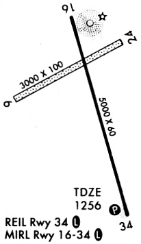
| Runways: | 06/24 16/34 |
| Longest Runway: | 16/34 is 5000 ft (1524 m) long |
| Runways with an Instrument Approach: |
GWR Airport Runway Details
| Runway 06/24 | 2991 ft x 100 ft (912 m x 30 m) | |
| Runway Length Source: | 3RD PARTY SURVEY as of 12/18/2013 | |
| Surface: | Turf - Good condition - No special surface treatment | |
Runway 06 |
Runway 24 |
|
Elevation: |
1265.1 | 1249.1 |
Latitude: |
46-13-06.6070N | 46-13-20.9400N |
Longitude: |
097-39-02.2160W | 097-38-25.0330W |
|
Runway True Alignment: |
061 | 241 |
Glide Path Angle: |
0.0 degrees | 0.0 degrees |
Traffic Pattern: |
Left | Left |
| Runway 16/34 | 5000 ft x 75 ft (1524 m x 23 m) | |
| Runway Length Source: | 3RD PARTY SURVEY as of 12/18/2013 | |
| Surface: | Turf - Good condition - Saw-cut or plastic grooved | |
| Runway Edge Lights: | Medium Intensity | |
Runway Weight Bearing Capacity (in thousands of pounds) |
||
| Single Wheel Landing Gear: | 14.0 | |
| Dual Wheel Landing Gear: | 19.0 | |
Runway 16 |
Runway 34 |
|
Elevation: |
1255.2 | 1255.1 |
Latitude: |
46-13-24.7130N | 46-12-37.3060N |
Longitude: |
097-38-41.4800W | 097-38-21.6890W |
|
Runway True Alignment: |
164 | 344 |
Glide Path Angle: |
3.0 degrees | 3.0 degrees |
Traffic Pattern: |
Left | Left |
Runway Markings Type: |
Nonprecision Instrument | Nonprecision Instrument |
Runway Markings Condition: |
Good | Good |
Visual Glide Slope Indicators: |
2-Light PAPI On Left Side Of Runway | 2-Light PAPI On Left Side Of Runway |
REIL: |
Yes | Yes |
Threshold Crossing Height: |
25 | 25 |
Services
Fuel Available: |
100LL |
Landing Fees: |
No |
Parking: |
Tiedowns available |
Maps & Diagrams
GWR Sectional
Flight Planning
at skyvector.com
at skyvector.com