Location
Latitude: |
35-03-34.9000N (35.059694) |
Longitude: |
086-33-50.4000W (-86.564) |
Elevation: |
983.9 feet MSL (300 m MSL) |
Magnetic Variation: |
4.2 W (as of April 2024 from WMM2020 model) |
Time Zone: |
UTC -6.0 (Standard Time) UTC -5.0 (Daylight Savings Time) |
From City: |
06 N.M. S of Fayetteville, Tennessee |
Found On: |
Atlanta Chart |
FAA Region: |
ASO |
Contacts
Manager: |
Publicly owned: |
| MARK COBB 37 AIRPORT RD FAYETTEVILLE, TN 37334 931-433-1960 |
FAYETTEVILLE-LINCOLN ARPT AUTH 37 AIRPORT ROAD FAYETTEVILLE, TN 37334 931-433-1960 |
Operations
Airport Status: |
Operational |
Facility Use: |
Public |
Type: |
Airport |
Control tower: |
No |
Attendance (Months/Days/Hours): |
Months/Days/Hours ALL/MON-FRI/0800-1630 |
Boundary ARTCC: |
ZME (Memphis) |
Responsible ARTCC: |
ZME (Memphis) |
Lighting Schedule: |
SEE RMK |
Segmented Circle Indicator: |
Yes |
Traffic Pattern Altitude (MSL): |
1984 feet (605 m) |
NOTAMs Facility: |
MKL |
NOTAM-D Service: |
Yes |
International Airport of Entry: |
No |
Customs Landing Rights: |
No |
Military Landing Rights: |
Yes |
Civil/Military Joint Use: |
No |
Based Aircraft
| Single Engine: | 21 |
| Multi Engine: | 11 |
| Jet Engine: | 1 |
Annual Operations (as of 08/31/2017)
| Total Operations: | 24680 | |
| Air Taxi: | 180 | 0.7% |
| GA Local: | 8500 | 34.4% |
| GA Itinerant: | 12500 | 50.6% |
| Military Aircraft: | 3500 | 14.2% |
Communications
| CTAF: | 122.800 |
| Unicom: | 122.800 |
| Approach: | HUNTSVILLE 125.6 125.6 MEMPHIS ARTCC |
| Departure: | HUNTSVILLE 125.6 125.6 MEMPHIS ARTCC |
| AWOS-3: | 135.275 (931-433-5916) |
- APCH/DEP SVC PRVDD BY MEMPHIS ARTCC ON FREQS 120.8/307.0 (HUNTSVILLE RCAG) WHEN HUNTSVILLE APCH CTL CLSD.
Fixed Based Operators (FBOs) & Fuel
(Click on a business for detail)
Please help us keep this information up to date. This is a FREE SERVICE just like everything else on Airport Guide! If you see that a business needs to be added, modified, or deleted please fill out our Update Form.
To add, modify, or delete a business click here.
Please help us keep this information up to date. This is a FREE SERVICE just like everything else on Airport Guide! If you see that a business needs to be added, modified, or deleted please fill out our Update Form.
Area Code: 931 |
| Business Name | Frequency | Phone | Fuel Grade |
|---|
Flight Service Stations
| Primary | Alternate | |
| FSS on Field: | N | |
| FSS Name (ID): | Jackson(MKL) | |
| Frequency: | ||
| Toll Free Phone: | 1-800-WX-BRIEF |
Instrument Procedures / Charts
FAA Terminal Procedures valid from 0901Z 03/21/24 to 0901Z 04/18/24.
There are various types of charts available for an airport. They are listed in the Page Type column. Here is a legend for those types:
APD - Airport Diagram
DP - Departure Procedure Charts
HOT - Hot Spots
IAP - Instrument Approach Procedure Charts
MIN - Minimums
STAR - Standard Terminal Arrival Charts
| Page Type | Page Name | Volume | Action Since Last Cycle |
|---|---|---|---|
| IAP | RNAV (GPS) RWY 02 | SE-1 | |
| IAP | RNAV (GPS) RWY 20 | SE-1 | |
| IAP | VOR/DME RWY 02 | SE-1 | |
| MIN | TAKEOFF MINIMUMS | SE-1 |
Terminal Procedures are only available for airports in several countries with more being added all the time. If you are looking for a specific country's charts, please send an email to support(at)airportguide.com stating the country name. This will be used to prioritize the implementation.
Navigation Aids (Navaids) near FYM
| Dist (NM) | ID | Morse Code | Name | Type | Freq | True Hdg | Mag Hdg |
|---|---|---|---|---|---|---|---|
| 4.6 | TNY | _ _ . _ . _ _ | Kelso | NDB | 358 | 13 | 17 |
| 16.1 | RQZ | . _ . _ _ . _ _ _ . . | Rocket | VORTAC | 112.20 | 192 | 196 |
| 20.2 | CWH | _ . _ . . _ _ . . . . | Capshaw | NDB | 350 | 211 | 215 |
| 22.5 | HUA | . . . . . . _ . _ | Redstone | NDB | 287 | 195 | 199 |
| 24.8 | UXM | . . _ _ . . _ _ _ | Tullahoma Regional | VOR | 109.65 | 38 | 42 |
| 25.3 | BGF | _ . . . _ _ . . . _ . | Boiling Fork | NDB | 263 | 73 | 77 |
| 25.9 | SYI | . . . _ . _ _ . . | Bomar | FAN MARKER | 10 | 14 | |
| 27.2 | HSV | . . . . . . . . . . _ | Huntsville | VOT | 111.00 | 202 | 206 |
| 28.8 | ULH | . . _ . _ . . . . . . | Burwi | NDB | 332 | 33 | 37 |
| 29.1 | LUG | . _ . . . . _ _ _ . | Verona | NDB | 251 | 335 | 339 |
| 30.8 | SYI | . . . _ . _ _ . . | Shelbyville | VOR-DME | 113.55 | 11 | 15 |
| 30.8 | DCU | _ . . _ . _ . . . _ | Decatur | DME | 112.8 | 216 | 220 |
| 35.8 | LRT | . _ . . . _ . _ | Lawrenceburg | NDB | 269 | 287 | 291 |
| 41.8 | PBC | . _ _ . _ . . . _ . _ . | Maury County | NDB | 365 | 322 | 326 |
| 48.1 | APT | . _ . _ _ . _ | Jasper | NDB | 382 | 89 | 94 |
| 50.3 | MSL | _ _ . . . . _ . . | Muscle Shoals | DME | 116.25 | 245 | 249 |
| 51.2 | ARF | . _ . _ . . . _ . | Saratoga | NDB | 296 | 160 | 164 |
| 54.0 | SWZ | . . . . _ _ _ _ . . | Sewart | NDB | 391 | 5 | 9 |
| 54.5 | FTP | . . _ . _ . _ _ . | Fort Payne | NDB | 426 | 126 | 130 |
| 54.9 | FQW | . . _ . _ _ . _ . _ _ | Walter Hill | NDB | 371 | 9 | 13 |
Nearby Airports with Fuel
Notices to Airmen (NOTAMS)
Remarks
| A11 | FAYETTEVILLE-LINCOLN COUNTY REGIONAL AIRPORT AUTHORITY. |
| A110-1 | FOR CD CTC HUNTSVILLE APCH ON GCO FREQ, IF UNA ON FREQ, CTC HUNTSVILLE APCH AT 256-542-2097, WHEN APCH CLSD CTC MEMPHIS ARTCC AT 901-368-8453/8449. |
| A110-2 | GCO AVBL ON FREQ 121.725, 4 CLICKS. |
| A17 | CLSD CHRISTMAS, 4TH JULY, LABOR DAY AND EASTER. |
| A52-02 | APCH RATIO 33:1 TO DSPLCD THR. |
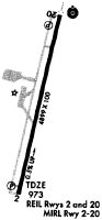
| A81-APT | ACTVT ODALS RWY 20; REIL RWY 02 & 20 - CTAF. PAPI RWY 02 & 20 OPR CONSLY. MIRL RWY 02/20 OPR DUSK-DAWN. |
Runways
Runway Summary
| Runways: | 02/20 |
| Longest Runway: | 02/20 is 5900 ft (1798 m) long |
| Runways with an Instrument Approach: | 20 |
FYM Airport Runway Details
| Runway 02/20 | 5900 ft x 100 ft (1798 m x 30 m) | |
| Runway Length Source: | OWNER as of 05/03/2006 | |
| Surface: | Asphalt - Good condition - No special surface treatment | |
| Runway Edge Lights: | Medium Intensity | |
Runway Weight Bearing Capacity (in thousands of pounds) |
||
| Single Wheel Landing Gear: | 21.0 | |
| Dual Wheel Landing Gear: | 31.0 | |
Runway 02 |
Runway 20 |
|
Elevation: |
959.6 | 983.3 |
Latitude: |
35-03-06.5922N | 35-04-03.2480N |
Longitude: |
086-33-58.9299W | 086-33-41.9434W |
|
Runway True Alignment: |
014 | 194 |
ILS Type: |
SDF | |
Glide Path Angle: |
3.0 degrees | 3.0 degrees |
Traffic Pattern: |
Left | Left |
Runway Markings Type: |
Nonprecision Instrument | Nonprecision Instrument |
Runway Markings Condition: |
Good | Good |
Object at End: |
TREES | TREES |
Object Height: |
82 | 78 |
Distance from End: |
1965 | 2106 |
Object Centerline Offset: |
485 ft. right of centerline | 195 ft. left of centerline |
Visual Glide Slope Indicators: |
4-Light PAPI On Left Side Of Runway | 4-Light PAPI On Right Side Of Runway |
Approach Light System: |
Omnidirectional Approach Lighting System | |
REIL: |
Yes | Yes |
Threshold Crossing Height: |
22 | 20 |
Threshold Elevation: |
959.7 | |
Displaced Threshold: |
400 | |
Threshold Latitude: |
35-03-10.4300N | |
Threshold Longitude: |
086-33-57.7800W | |
Declared Distances |
||
Take Off Run Avbl. (TORA): |
5900 | 5900 |
Take Off Distance Avbl. (TODA): |
5900 | |
Actual Stop Dist. Avbl. (ASDA): |
5900 | 5900 |
Landing Dist. Avbl. (LDA): |
5500 | 5900 |
Services
Airframe Repair: |
None |
Powerplant Repair: |
None |
Bottled Oxygen: |
None |
Bulk Oxygen: |
None |
Fuel Available: |
100LL, Jet A |
Landing Fees: |
No |
Parking: |
Tiedowns available |
Maps & Diagrams
FYM Sectional
Flight Planning
at skyvector.com
at skyvector.com