Location
Latitude: |
39-29-57.0100N (39.499169) |
Longitude: |
118-44-55.6520W (-118.748792) |
Elevation: |
3966.4 feet MSL (1209 m MSL) |
Magnetic Variation: |
12.7 E (as of April 2024 from WMM2020 model) |
Time Zone: |
UTC -8.0 (Standard Time) UTC -7.0 (Daylight Savings Time) |
From City: |
02 N.M. NE of Fallon, Nevada |
Found On: |
San Francisco Chart |
FAA Region: |
AWP |
Contacts
Manager: |
Publicly owned: |
| DEREK ZIMNEY 55 WEST WILLIAMS AVE FALLON, NV 89406 775-213-3457 |
CITY OF FALLON 55 WEST WILLIAMS AVE FALLON, NV 89406 775-423-5107 |
Operations
Airport Status: |
Operational |
Facility Use: |
Public |
Type: |
Airport |
Activation Date: |
08/1952 |
Control tower: |
No |
Attendance (Months/Days/Hours): |
Months/Days/Hours ALL/ALL/0800-1700 |
Boundary ARTCC: |
ZOA (Oakland) |
Responsible ARTCC: |
ZOA (Oakland) |
Lighting Schedule: |
SS-SR |
Segmented Circle Indicator: |
Yes |
Traffic Pattern Altitude (MSL): |
4966 feet (1514 m) |
NOTAMs Facility: |
RNO |
NOTAM-D Service: |
Yes |
International Airport of Entry: |
No |
Customs Landing Rights: |
No |
Military Landing Rights: |
Yes |
Civil/Military Joint Use: |
No |
Based Aircraft
| Single Engine: | 75 |
| Multi Engine: | 2 |
| GA Helicopters: | 2 |
Annual Operations (as of 02/28/2021)
| Total Operations: | 9240 | |
| Air Taxi: | 720 | 7.8% |
| GA Local: | 3600 | 39.0% |
| GA Itinerant: | 4200 | 45.5% |
| Military Aircraft: | 720 | 7.8% |
Communications
| CTAF: | 122.800 |
| Unicom: | 122.800 |
| Approach: | NAVY FALLON 120.85 120.85 OAKLAND ARTCC |
| Departure: | NAVY FALLON 120.85 120.85 OAKLAND ARTCC |
| AWOS-AV: | 118.25 (775-423-2201) |
- APCH/DEP CTL SVC PRVDD BY OAKLAND ARTCC (ZOA) ON FREQ 128.8/285.5 (FALLON RCAG), WHEN NAVY FALLON APCH CTL (NFL) CLSD.
- COMMUNICATIONS PRVDD BY RENO RADIO ON FREQS 122.1R/114.1T (HAZEN RCO).
Fixed Based Operators (FBOs) & Fuel
(Click on a business for detail)
Please help us keep this information up to date. This is a FREE SERVICE just like everything else on Airport Guide! If you see that a business needs to be added, modified, or deleted please fill out our Update Form.
To add, modify, or delete a business click here.
Please help us keep this information up to date. This is a FREE SERVICE just like everything else on Airport Guide! If you see that a business needs to be added, modified, or deleted please fill out our Update Form.
Area Code: 775 |
| Business Name | Frequency | Phone | Fuel Grade |
|---|---|---|---|
| Fallon Airmotive
Update FBO info |
Unicom 122.8 | 423-3756 | 100LL, Jet A |
Flight Service Stations
| Primary | Alternate | |
| FSS on Field: | N | |
| FSS Name (ID): | Reno(RNO) | |
| Frequency: | ||
| Toll Free Phone: | 1-800-WX-BRIEF |
Instrument Procedures / Charts
FAA Terminal Procedures valid from 0901Z 03/21/24 to 0901Z 04/18/24.
There are various types of charts available for an airport. They are listed in the Page Type column. Here is a legend for those types:
APD - Airport Diagram
DP - Departure Procedure Charts
HOT - Hot Spots
IAP - Instrument Approach Procedure Charts
MIN - Minimums
STAR - Standard Terminal Arrival Charts
| Page Type | Page Name | Volume | Action Since Last Cycle |
|---|---|---|---|
| APD | AIRPORT DIAGRAM | SW-4 | |
| IAP | RNAV (GPS)-C | SW-4 | |
| IAP | VOR-B | SW-4 | |
| MIN | TAKEOFF MINIMUMS | SW-4 |
Terminal Procedures are only available for airports in several countries with more being added all the time. If you are looking for a specific country's charts, please send an email to support(at)airportguide.com stating the country name. This will be used to prioritize the implementation.
Navigation Aids (Navaids) near FLX
| Dist (NM) | ID | Morse Code | Name | Type | Freq | True Hdg | Mag Hdg |
|---|---|---|---|---|---|---|---|
| 5.3 | NFL | _ . . . _ . . _ . . | Fallon | TACAN | 113.50 | 157 | 144 |
| 11.6 | HZN | . . . . _ _ . . _ . | Hazen | VORTAC | 114.10 | 275 | 262 |
| 38.4 | LLC | . _ . . . _ . . _ . _ . | Lovelock | VORTAC | 116.50 | 11 | 358 |
| 42.0 | FMG | . . _ . _ _ _ _ . | Mustang | VORTAC | 117.90 | 272 | 259 |
| 65.2 | MVA | _ _ . . . _ . _ | Mina | VORTAC | 115.10 | 149 | 137 |
| 73.1 | SWR | . . . . _ _ . _ . | Squaw Valley | VOR-DME | 113.20 | 255 | 242 |
| 79.4 | AHC | . _ . . . . _ . _ . | Amedee | VOR-DME | 109.00 | 305 | 292 |
| 94.3 | INA | . . _ . . _ | Winnemucca | VOR-DME | 108.20 | 26 | 13 |
| 94.8 | UUC | . . _ . . _ _ . _ . | Winnie | DME | 113.75 | 26 | 13 |
Nearby Airports with Fuel
| Dist (NM) | Name (Airport IDs) | True Hdg | Mag Hdg | Fuel Grade |
|---|---|---|---|---|
| 35.1 | Derby Field Airport (LOL KLOL LOL) |
13 | 0 | 100LL |
| 35.2 | Yerington Municipal Airport (O43) |
212 | 199 | 100LL |
| 47.2 | Reno/Tahoe International Airport (RNO KRNO RNO) |
270 | 257 | 100LL, Jet A-1+ |
| 48.2 | Rosaschi Air Park Airport (N59) |
214 | 201 | 100LL |
| 49.2 | Carson City Airport (CSN KCXP CXP) |
248 | 235 | 100LL, Jet A |
| 53.1 | Reno/Stead Airport (KRTS RTS) |
281 | 268 | 100LL, Jet A |
| 55.4 | Minden-Tahoe Airport (MEV KMEV MEV) |
237 | 224 | 100LL, Jet A |
| 57.5 | Hawthorne Industrial Airport (HTH KHTH HTH) |
174 | 162 | 100LL, Jet A |
| 65.4 | Truckee-Tahoe Airport (TKF KTRK TRK) |
260 | 247 | 100LL, Jet A, Jet A-1+ |
| 68.4 | Lake Tahoe Airport (TVL KTVL TVL) |
238 | 225 | 100LL, Jet A |
| 76.5 | Nervino Airport (O02) |
285 | 272 | 100LL, Jet A |
| 77.3 | Bryant Field Airport (O57) |
196 | 183 | 100LL |
| 94.3 | Winnemucca Municipal Airport (WMC KWMC WMC) |
26 | 13 | 100LL, Jet A |
| 99.0 | Susanville Municipal Airport (SVE KSVE SVE) |
302 | 289 | 100LL, Jet A |
Notices to Airmen (NOTAMS)
Remarks
| A110-1 | OVHD JET & ULTRALIGHT ACT INVOF ARPT. |
| A110-3 | FOR CD CTC OAKLAND ARTCC AT 510-745-3380. |
| A110-5 | LINE OF SIGHT BTN RWY 03 & 13 END BLOCKED; TMT ALL ARR & DEP. |
| A110-6 | (CONTACT PHONE NR) 775-426-9996 |
| A14 | BRIAN BYRD |
| A54-13 | TREES ON CARSON RIVER. |
| A57-13 | TREES ON CARSON RIVER. |
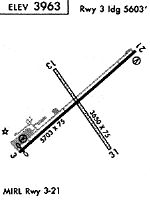
Runways
Runway Summary
| Runways: | 03/21 13/31 |
| Longest Runway: | 03/21 is 5705 ft (1739 m) long |
| Runways with an Instrument Approach: |
FLX Airport Runway Details
| Runway 03/21 | 5705 ft x 75 ft (1739 m x 23 m) | |
| Runway Length Source: | 3RD PARTY SURVEY as of 09/21/2017 | |
| Surface: | Asphalt - Excellent condition - No special surface treatment | |
| Runway Edge Lights: | Medium Intensity | |
Runway Weight Bearing Capacity (in thousands of pounds) |
||
| Single Wheel Landing Gear: | 17.0 | |
Runway 03 |
Runway 21 |
|
Elevation: |
3966.3 | 3962.9 |
Latitude: |
39-29-39.6750N | 39-30-17.0450N |
Longitude: |
118-45-23.6989W | 118-44-29.2253W |
|
Runway True Alignment: |
048 | 228 |
Glide Path Angle: |
3.0 degrees | 3.0 degrees |
Traffic Pattern: |
Left | Left |
Runway Markings Type: |
Nonprecision Instrument | Nonprecision Instrument |
Runway Markings Condition: |
Good | Good |
Object at End: |
ROAD | TREES |
Object Height: |
14 | 88 |
Distance from End: |
475 | 1900 |
Object Centerline Offset: |
0 ft. left and right of centerline | 100 ft. right of centerline |
Visual Glide Slope Indicators: |
2-Light PAPI On Left Side Of Runway | 2-Light PAPI On Left Side Of Runway |
REIL: |
No | No |
Threshold Crossing Height: |
40 | 40 |
Threshold Elevation: |
3966.3 | |
Displaced Threshold: |
102 | |
Threshold Latitude: |
39-29-40.3431N | |
Threshold Longitude: |
118-45-22.7260W | |
Declared Distances |
||
Take Off Run Avbl. (TORA): |
5703 | 5703 |
Take Off Distance Avbl. (TODA): |
5703 | 5703 |
| Runway 13/31 | 3581 ft x 60 ft (1091 m x 18 m) | |
| Runway Length Source: | 3RD PARTY SURVEY as of 09/21/2017 | |
| Surface: | Asphalt - Excellent condition - No special surface treatment | |
Runway 13 |
Runway 31 |
|
Elevation: |
3962.0 | 3961.4 |
Latitude: |
39-30-09.4590N | 39-29-40.2542N |
Longitude: |
118-45-07.2540W | 118-44-41.4623W |
|
Runway True Alignment: |
146 | 326 |
Glide Path Angle: |
0.0 degrees | 0.0 degrees |
Traffic Pattern: |
Left | Left |
Object at End: |
TREES | ROAD |
Object Height: |
29 | 10 |
Distance from End: |
490 | 250 |
Object Centerline Offset: |
0 ft. left and right of centerline | 100 ft. right of centerline |
REIL: |
No | No |
Services
Airframe Repair: |
Major |
Powerplant Repair: |
Major |
Bottled Oxygen: |
None |
Bulk Oxygen: |
None |
Fuel Available: |
100LL, Jet A |
Landing Fees: |
No |
Parking: |
Tiedowns available |
Maps & Diagrams
FLX Sectional
Flight Planning
at skyvector.com
at skyvector.com