Location
Latitude: |
32-54-37.7000N (32.910472) |
Longitude: |
099-44-03.0000W (-99.734167) |
Elevation: |
1560.8 feet MSL (476 m MSL) |
Magnetic Variation: |
4.4 E (as of April 2024 from WMM2020 model) |
Time Zone: |
UTC -6.0 (Standard Time) UTC -5.0 (Daylight Savings Time) |
From City: |
04 N.M. SE of Stamford, Texas |
Found On: |
Dallas-Ft Worth Chart |
FAA Region: |
ASW |
Contacts
Manager: |
Publicly owned: |
| ALAN PLUMLEE 201 E. MC HARG, PO BOX 191 STAMFORD, TX 79553 325-773-2591 |
CITY OF STAMFORD 201 E. MC HARG, PO BOX 191 STAMFORD, TX 79553 325-773-2591 |
Operations
Airport Status: |
Operational |
Facility Use: |
Public |
Type: |
Airport |
Activation Date: |
09/1941 |
Control tower: |
No |
Attendance (Months/Days/Hours): |
Months/Days/Hours Unattended |
Boundary ARTCC: |
ZFW (Fort Worth) |
Responsible ARTCC: |
ZFW (Fort Worth) |
Lighting Schedule: |
SEE RMK |
Segmented Circle Indicator: |
Yes |
Traffic Pattern Altitude (MSL): |
2561 feet (781 m) |
NOTAMs Facility: |
FTW |
NOTAM-D Service: |
Yes |
International Airport of Entry: |
No |
Customs Landing Rights: |
No |
Military Landing Rights: |
Yes |
Civil/Military Joint Use: |
No |
Based Aircraft
| Single Engine: | 11 |
| Multi Engine: | 4 |
Annual Operations (as of 11/13/2023)
| Total Operations: | 4900 | |
| GA Local: | 3300 | 67.3% |
| GA Itinerant: | 1600 | 32.7% |
Communications
| CTAF: | 122.800 |
| Unicom: | 122.800 |
| Approach: | ABILENE 127.2 127.2 |
| Departure: | ABILENE 127.2 127.2 |
Fixed Based Operators (FBOs) & Fuel
(Click on a business for detail)
Please help us keep this information up to date. This is a FREE SERVICE just like everything else on Airport Guide! If you see that a business needs to be added, modified, or deleted please fill out our Update Form.
To add, modify, or delete a business click here.
Please help us keep this information up to date. This is a FREE SERVICE just like everything else on Airport Guide! If you see that a business needs to be added, modified, or deleted please fill out our Update Form.
Area Code: 915 |
| Business Name | Frequency | Phone | Fuel Grade |
|---|---|---|---|
| Stamford Flying Service
Update FBO info |
773-3392 |
Flight Service Stations
| Primary | Alternate | |
| FSS on Field: | N | |
| FSS Name (ID): | Fort Worth(FTW) | |
| Frequency: | ||
| Toll Free Phone: | 1-800-WX-BRIEF |
Instrument Procedures / Charts
FAA Terminal Procedures valid from 0901Z 03/21/24 to 0901Z 04/18/24.
There are various types of charts available for an airport. They are listed in the Page Type column. Here is a legend for those types:
APD - Airport Diagram
DP - Departure Procedure Charts
HOT - Hot Spots
IAP - Instrument Approach Procedure Charts
MIN - Minimums
STAR - Standard Terminal Arrival Charts
| Page Type | Page Name | Volume | Action Since Last Cycle |
|---|---|---|---|
| IAP | RNAV (GPS) RWY 17 | SC-2 | |
| IAP | RNAV (GPS) RWY 35 | SC-2 | |
| MIN | TAKEOFF MINIMUMS | SC-2 |
Terminal Procedures are only available for airports in several countries with more being added all the time. If you are looking for a specific country's charts, please send an email to support(at)airportguide.com stating the country name. This will be used to prioritize the implementation.
Navigation Aids (Navaids) near F56
| Dist (NM) | ID | Morse Code | Name | Type | Freq | True Hdg | Mag Hdg |
|---|---|---|---|---|---|---|---|
| 16.9 | AKL | . _ _ . _ . _ . . | Haskell | NDB | 407 | 2 | 358 |
| 26.6 | ABI | . _ _ . . . . . | Abilene | VORTAC | 113.70 | 194 | 190 |
| 30.2 | DYS | _ . . _ . _ _ . . . | Dyess | TACAN | 133.60 | 191 | 187 |
| 36.8 | AB | . _ _ . . . | Tomhi | NDB | 353 | 175 | 171 |
| 40.7 | TQA | _ _ _ . _ . _ | Tuscola | VOR-DME | 111.60 | 185 | 181 |
| 45.7 | SWW | . . . . _ _ . _ _ | Sweetwater | NDB | 275 | 234 | 229 |
| 55.9 | OIP | _ _ _ . . . _ _ . | Old Rip | NDB | 410 | 123 | 119 |
| 60.2 | GTH | _ _ . _ . . . . | Guthrie | DME | 114.5 | 330 | 325 |
| 62.4 | SDR | . . . _ . . . _ . | Snyder | NDB | 359 | 258 | 253 |
| 64.1 | GHX | _ _ . . . . . _ . . _ | Graham | NDB | 371 | 75 | 71 |
| 72.6 | BWD | _ . . . . _ _ _ . . | Brownwood | VOR-DME | 113.55 | 147 | 143 |
| 74.8 | UBC | . . _ _ . . . _ . _ . | Ballinger | NDB | 239 | 189 | 185 |
| 81.5 | SKB | . . . _ . _ _ . . . | Scotland | NDB | 344 | 49 | 45 |
| 86.2 | SPS | . . . . _ _ . . . . | Wichita Falls | VORTAC | 112.70 | 41 | 37 |
| 86.8 | CZX | _ . _ . _ _ . . _ . . _ | Crosbyton | NDB | 332 | 299 | 294 |
| 87.8 | ICF | . . _ . _ . . . _ . | Madison | NDB | 296 | 46 | 42 |
| 88.3 | MQP | _ _ _ _ . _ . _ _ . | Millsap | VORTAC | 117.70 | 96 | 92 |
| 89.6 | SHP | . . . . . . . . _ _ . | Sheppard | TACAN | 110.80 | 43 | 39 |
| 91.8 | CDS | _ . _ . _ . . . . . | Childress | VORTAC | 117.00 | 342 | 337 |
| 93.8 | BGS | _ . . . _ _ . . . . | Big Spring | VORTAC | 117.20 | 250 | 245 |
Nearby Airports with Fuel
Notices to Airmen (NOTAMS)
Remarks
| A110-1 | FARM EQUIPMENT INVOF AIRPORT. |
| A110-2 | FOR CD CTC FORT WORTH ARTCC AT 817-858-7584. |
| A14 | CITY MANAGER |
| A33-08/26 | RWY SFC ROUGH. |
| A33-13/31 | RWY SFC ROUGH. |
| A58-17 | 10 FT ROAD 60 FT EAST OF RWY CNTRLN AT THR. |
| A81-APT | ACTVT MIRL RWY 17/35 - CTAF. |
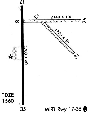
Runways
Runway Summary
| Runways: | 08/26 13/31 17/35 |
| Longest Runway: | 17/35 is 3707 ft (1130 m) long |
| Runways with an Instrument Approach: |
F56 Airport Runway Details
| Runway 08/26 | 2211 ft x 50 ft (674 m x 15 m) | |
| Runway Length Source: | 3RD PARTY SURVEY as of 08/07/2011 | |
| Surface: | Turf - Poor condition - No special surface treatment | |
Runway 08 |
Runway 26 |
|
Elevation: |
1560.0 | 1554.9 |
Latitude: |
32-54-44.8465N | 32-54-44.4765N |
Longitude: |
099-44-09.8295W | 099-43-43.9050W |
|
Runway True Alignment: |
091 | 271 |
Glide Path Angle: |
0.0 degrees | 0.0 degrees |
Traffic Pattern: |
Left | Left |
| Runway 13/31 | 1702 ft x 50 ft (519 m x 15 m) | |
| Runway Length Source: | 3RD PARTY SURVEY as of 08/07/2011 | |
| Surface: | Turf - Poor condition - No special surface treatment | |
Runway 13 |
Runway 31 |
|
Elevation: |
1558.0 | 1552.5 |
Latitude: |
32-54-45.0759N | 32-54-33.0077N |
Longitude: |
099-44-03.4446W | 099-43-49.5220W |
|
Runway True Alignment: |
136 | 316 |
Glide Path Angle: |
0.0 degrees | 0.0 degrees |
Traffic Pattern: |
Left | Left |
Object at End: |
ROAD | ROAD |
Object Height: |
10 | 10 |
Distance from End: |
0 | 0 |
| Runway 17/35 | 3707 ft x 60 ft (1130 m x 18 m) | |
| Runway Length Source: | 3RD PARTY SURVEY as of 08/07/2011 | |
| Surface: | Turf - Poor condition - No special surface treatment | |
| Runway Edge Lights: | Medium Intensity | |
Runway Weight Bearing Capacity (in thousands of pounds) |
||
| Single Wheel Landing Gear: | 4.0 | |
Runway 17 |
Runway 35 |
|
Elevation: |
1560.6 | 1553.8 |
Latitude: |
32-54-51.2536N | 32-54-14.5814N |
Longitude: |
099-44-09.4282W | 099-44-09.7332W |
|
Runway True Alignment: |
180 | 000 |
Glide Path Angle: |
0.0 degrees | 0.0 degrees |
Traffic Pattern: |
Left | Left |
Runway Markings Type: |
Nonprecision Instrument | Nonprecision Instrument |
Runway Markings Condition: |
Good | Good |
Object at End: |
ROAD | |
Object Height: |
15 | |
Distance from End: |
860 |
Services
Fuel Available: |
100LL |
Landing Fees: |
No |
Parking: |
Tiedowns available |
Maps & Diagrams
F56 Sectional
Flight Planning
at skyvector.com
at skyvector.com