Location
Latitude: |
26-50-45.3000N (26.845917) |
Longitude: |
080-13-20.4000W (-80.222333) |
Elevation: |
22.0 feet MSL (7 m MSL) |
Magnetic Variation: |
7.3 W (as of April 2024 from WMM2020 model) |
Time Zone: |
UTC -5.0 (Standard Time) UTC -4.0 (Daylight Savings Time) |
From City: |
12 N.M. NW of West Palm Beach, Florida |
Found On: |
Miami Chart |
FAA Region: |
ASO |
Contacts
Manager: |
Publicly owned: |
| LAURA BEEBE 846 PALM BEACH INTL AIRPORT WEST PALM BEACH, FL 33406-1470 561-471-7420 |
PALM BEACH COUNTY DEPARTMENT OF AIRPORTS, 846 PBIA WEST PALM BEACH, FL 33406-1470 561-471-7404 |
Operations
Airport Status: |
Operational |
Facility Use: |
Public |
Type: |
Airport |
Activation Date: |
04/1994 |
Control tower: |
No |
Attendance (Months/Days/Hours): |
Months/Days/Hours ALL/ALL/0600-2200 |
Boundary ARTCC: |
ZMA (Miami) |
Responsible ARTCC: |
ZMA (Miami) |
Lighting Schedule: |
SEE RMK |
Segmented Circle Indicator: |
Yes, Lighted |
Traffic Pattern Altitude (MSL): |
1022 feet (312 m) |
NOTAMs Facility: |
MIA |
NOTAM-D Service: |
Yes |
Based Aircraft
| Single Engine: | 137 |
| Multi Engine: | 28 |
| Jet Engine: | 4 |
| GA Helicopters: | 11 |
| Gliders: | 1 |
Annual Operations (as of 12/31/2018)
| Total Operations: | 97400 | |
| Air Taxi: | 7300 | 7.5% |
| GA Local: | 68050 | 69.9% |
| GA Itinerant: | 21950 | 22.5% |
| Military Aircraft: | 100 | 0.1% |
Communications
| CTAF: | 123.075 |
| Unicom: | 123.075 |
| Approach: | PALM BEACH |
| Departure: | PALM BEACH |
| AWOS-3: | 119.975 (561-630-6932) |
Fixed Based Operators (FBOs) & Fuel
(Click on a business for detail)
Please help us keep this information up to date. This is a FREE SERVICE just like everything else on Airport Guide! If you see that a business needs to be added, modified, or deleted please fill out our Update Form.
To add, modify, or delete a business click here.
Please help us keep this information up to date. This is a FREE SERVICE just like everything else on Airport Guide! If you see that a business needs to be added, modified, or deleted please fill out our Update Form.
Area Code: 561 |
| Business Name | Frequency | Phone | Fuel Grade |
|---|---|---|---|
| Aircraft Maintenance Specialists
Update FBO info |
+1 561 625-7979 | ||
| O'Brien Aviation, Inc.
Update FBO info |
+1 561 775-6100 | ||
| Signature Flight Support
Website Update FBO info |
Unicom: 123.075, Arinc: 131.25 | +1 561 626-9799 | 100LL, Jet A |
| Sunquest Aviation
Update FBO info |
+1 561 627-0037 |
Flight Service Stations
| Primary | Alternate | |
| FSS on Field: | N | |
| FSS Name (ID): | Miami(MIA) | |
| Frequency: | ||
| Toll Free Phone: | 1-800-WX-BRIEF |
Instrument Procedures / Charts
FAA Terminal Procedures valid from 0901Z 03/21/24 to 0901Z 04/18/24.
There are various types of charts available for an airport. They are listed in the Page Type column. Here is a legend for those types:
APD - Airport Diagram
DP - Departure Procedure Charts
HOT - Hot Spots
IAP - Instrument Approach Procedure Charts
MIN - Minimums
STAR - Standard Terminal Arrival Charts
| Page Type | Page Name | Volume | Action Since Last Cycle |
|---|---|---|---|
| IAP | ILS OR LOC RWY 09R | SE-3 | |
| IAP | RNAV (GPS) RWY 09R | SE-3 | |
| IAP | RNAV (GPS) RWY 14 | SE-3 | |
| IAP | RNAV (GPS) RWY 27L | SE-3 | |
| MIN | TAKEOFF MINIMUMS | SE-3 | |
| STAR | CLMNT TWO (RNAV) | SE-3 | |
| STAR | CLMNT TWO (RNAV)[DELIMITER] CONT.1 | SE-3 | |
| STAR | CLMNT TWO (RNAV)[DELIMITER] CONT.2 | SE-3 | |
| STAR | JESTR ONE (RNAV) | SE-3 | |
| STAR | JESTR ONE (RNAV)[DELIMITER] CONT.1 | SE-3 | |
| STAR | TTYLR THREE | SE-3 | Changed |
| STAR | VUUDU ONE (RNAV) | SE-3 | |
| STAR | VUUDU ONE (RNAV)[DELIMITER] CONT.1 | SE-3 | |
| STAR | VUUDU ONE (RNAV)[DELIMITER] CONT.2 | SE-3 |
Terminal Procedures are only available for airports in several countries with more being added all the time. If you are looking for a specific country's charts, please send an email to support(at)airportguide.com stating the country name. This will be used to prioritize the implementation.
Navigation Aids (Navaids) near F45
| Dist (NM) | ID | Morse Code | Name | Type | Freq | True Hdg | Mag Hdg |
|---|---|---|---|---|---|---|---|
| 7.1 | UTX | . . _ _ _ . . _ | United | NDB | 405 | 302 | 309 |
| 11.4 | PBI | . _ _ . _ . . . . . | Palm Beach | VOT | 109.00 | 146 | 153 |
| 12.3 | PBI | . _ _ . _ . . . . . | Palm Beach | VORTAC | 115.70 | 143 | 150 |
| 25.4 | PHK | . _ _ . . . . . _ . _ | Pahokee | VOR-DME | 115.40 | 261 | 268 |
| 39.3 | FPR | . . _ . . _ _ . . _ . | Fort Pierce | NDB | 275 | 348 | 355 |
| 39.9 | FX | . . _ . _ . . _ | Praiz | NDB | 221 | 185 | 192 |
| 46.4 | FLL | . . _ . . _ . . . _ . . | Fort Lauderdale | VOR-DME | 114.40 | 176 | 183 |
| 51.9 | TRV | _ . _ . . . . _ | Treasure | VORTAC | 117.30 | 344 | 351 |
| 62.6 | LBV | . _ . . _ . . . . . . _ | La Belle | VORTAC | 110.40 | 269 | 276 |
| 63.1 | DHP | _ . . . . . . . _ _ . | Dolphin | VORTAC | 113.90 | 186 | 193 |
| 63.1 | MIA | _ _ . . . _ | Miami Intl | VOT | 112.00 | 182 | 189 |
| 65.7 | VKZ | . . . _ _ . _ _ _ . . | Virginia Key | VOR-DME | 117.10 | 176 | 183 |
| 72.7 | TN | _ _ . | Monry | NDB | 227 | 215 | 222 |
| 73.8 | TM | _ _ _ | Qeezy | NDB | 266 | 191 | 198 |
| 78.7 | MLB | _ _ . _ . . _ . . . | Melbourne | VOR-DME | 115.85 | 343 | 350 |
| 79.4 | SQT | . . . _ _ . _ _ | Satellite | NDB | 257 | 341 | 348 |
| 80.0 | ZFP | _ _ . . . . _ . . _ _ . | Freeport | NDB | 209 | 103 | 111 |
| 81.8 | HST | . . . . . . . _ | Homestead | TACAN | 108.20 | 185 | 192 |
| 83.6 | ZFP | _ _ . . . . _ . . _ _ . | Freeport | VOR-DME | 113.20 | 101 | 109 |
| 84.8 | ZBV | _ _ . . _ . . . . . . _ | Bimini | VORTAC | 116.70 | 143 | 151 |
Nearby Airports with Fuel
Notices to Airmen (NOTAMS)
Remarks
| A110-1 | NOISE ABATEMENT PROC; RWY 14/32 PREFERRED NGT RWY; H24 NOISE ABATEMENT MNTG - (561) 626-7631. |
| A110-10 | ARPT SFC COND NOT RPRTD FOR ALL RWYS. |
| A110-11 | FOR CD CTC PALM BEACH APCH AT 561-684-9047. |
| A110-12 | FBO SVC FEE MAY APPLY. |
| A110-13 | RWY 9R TDZ MRKGS NOT STD. |
| A110-5 | BIRD ACT INVOF ARPT. |
| A110-8 | EXTSV FLT TRNG MULT RWYS. PRACTICE APCH RWY 9R/27L MNT CTAF & YIELD TO TFC PAT. |
| A110-9 | TWY G1 CLSD. |
| A16 | 561-626-9771 |
| A17 | SVC AFR HRS - 561-626-9799 |
| A30-09R/27L | ACFT OVER 12500 LBS GWT NA. |
| A30-14/32 | ACFT OVER 30000 LBS NA. |
| A42-09L | PVC PIPE EV 200 FT. |
| A42-14 | THR MKR 4 FT BYD RWY END. |
| A42-27R | 09L/27R MKD WITH PVC PIPE EV 200 FT. |
| A81-APT | DUSK-2100; AFT 2100 ACTVT REIL RWY 09R, 14, 27L, & 32; MIRL RWY 09R/27L & 14/32 - CTAF. |
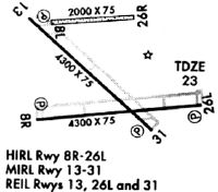
Runways
Runway Summary
| Runways: | 09L/27R 09R/27L 14/32 |
| Longest Runway: | 09R/27L is 4300 ft (1311 m) long |
| Runways with an Instrument Approach: | 09R |
F45 Airport Runway Details
| Runway 09L/27R | 3679 ft x 75 ft (1121 m x 23 m) | |
| Runway Length Source: | 3RD PARTY SURVEY as of 11/07/2009 | |
| Surface: | Turf - Good condition - No special surface treatment | |
Runway 09L |
Runway 27R |
|
Elevation: |
20.8 | 20.8 |
Latitude: |
26-50-57.0365N | 26-50-59.9720N |
Longitude: |
080-13-49.1724W | 080-13-08.6841W |
|
Runway True Alignment: |
085 | 265 |
Glide Path Angle: |
0.0 degrees | 0.0 degrees |
Traffic Pattern: |
Right | |
Runway Markings Type: |
Nonstandard (other than numbers only) | Nonstandard (other than numbers only) |
Runway Markings Condition: |
Fair | Fair |
Object at End: |
TREE | TREE |
Object Height: |
67 | 67 |
Distance from End: |
1655 | 1560 |
Object Centerline Offset: |
65 ft. right of centerline | 45 ft. right of centerline |
| Runway 09R/27L | 4300 ft x 100 ft (1311 m x 30 m) | |
| Runway Length Source: | 3RD PARTY SURVEY as of 11/07/2009 | |
| Surface: | Turf - Good condition - No special surface treatment | |
| Runway Pavement Class: | 11 /F/A/Y/T | |
| Runway Edge Lights: | Medium Intensity | |
Runway Weight Bearing Capacity (in thousands of pounds) |
||
| Single Wheel Landing Gear: | 12.5 | |
Runway 09R |
Runway 27L |
|
Elevation: |
21.3 | 21.3 |
Latitude: |
26-50-33.0935N | 26-50-36.5441N |
Longitude: |
080-13-36.7006W | 080-12-49.3884W |
|
Runway True Alignment: |
085 | 265 |
ILS Type: |
ILS/DME | |
Glide Path Angle: |
3.0 degrees | 3.0 degrees |
Traffic Pattern: |
Right | |
Runway Markings Type: |
Precision Instrument | Nonprecision Instrument |
Runway Markings Condition: |
Good | Good |
Object at End: |
TREE | |
Object Height: |
75 | |
Distance from End: |
2820 | |
Object Centerline Offset: |
65 ft. right of centerline | 45 ft. right of centerline |
Visual Glide Slope Indicators: |
2-Light PAPI On Left Side Of Runway | 2-Light PAPI On Left Side Of Runway |
REIL: |
Yes | Yes |
Threshold Crossing Height: |
40 | 40 |
| Runway 14/32 | 4300 ft x 75 ft (1311 m x 23 m) | |
| Runway Length Source: | 3RD PARTY SURVEY as of 11/07/2009 | |
| Surface: | Turf - Good condition - No special surface treatment | |
| Runway Pavement Class: | 10 /F/A/Y/T | |
| Runway Edge Lights: | Medium Intensity | |
Runway Weight Bearing Capacity (in thousands of pounds) |
||
| Single Wheel Landing Gear: | 30.0 | |
Runway 14 |
Runway 32 |
|
Elevation: |
21.3 | 21.2 |
Latitude: |
26-50-59.7131N | 26-50-29.4260N |
Longitude: |
080-13-37.2131W | 080-13-03.8508W |
|
Runway True Alignment: |
135 | 315 |
Glide Path Angle: |
3.0 degrees | 3.0 degrees |
Traffic Pattern: |
Right | |
Runway Markings Type: |
Nonprecision Instrument | Nonprecision Instrument |
Runway Markings Condition: |
Fair | Fair |
Object at End: |
TREES | TREES |
Object Height: |
51 | 33 |
Distance from End: |
2065 | 910 |
Object Centerline Offset: |
65 ft. right of centerline | 45 ft. right of centerline |
Visual Glide Slope Indicators: |
2-Light PAPI On Left Side Of Runway | 2-Light PAPI On Left Side Of Runway |
REIL: |
Yes | Yes |
Threshold Crossing Height: |
40 | 40 |
Services
Airframe Repair: |
Minor |
Powerplant Repair: |
Minor |
Bottled Oxygen: |
None |
Bulk Oxygen: |
None |
Fuel Available: |
100LL, Jet A, Jet A+ |
Landing Fees: |
No |
Parking: |
Hangars and tiedowns available |
Maps & Diagrams
F45 Sectional
Flight Planning
at skyvector.com
at skyvector.com