Location
Latitude: |
40-43-07.4110N (40.718725) |
Longitude: |
114-01-43.2250W (-114.028674) |
Elevation: |
4236.7 feet MSL (1291 m MSL) |
Magnetic Variation: |
11.6 E (as of April 2024 from WMM2020 model) |
Time Zone: |
UTC -7.0 (Standard Time) UTC -6.0 (Daylight Savings Time) |
From City: |
01 N.M. SE of Wendover, Utah |
Found On: |
Salt Lake City Chart |
FAA Region: |
ANM |
Contacts
Manager: |
Publicly owned: |
| LISA DUNN P.O. BOX 159 WENDOVER, UT 84083 435-843-3360 |
TOOELE COUNTY P.O. BOX 159 WENDOVER, UT 84083 435-665-2308 |
Operations
Airport Status: |
Operational |
Facility Use: |
Public |
Type: |
Airport |
Activation Date: |
02/1973 |
Control tower: |
No |
Attendance (Months/Days/Hours): |
Months/Days/Hours ALL/ALL/0800-1800 |
Boundary ARTCC: |
ZLC (Salt Lake City) |
Responsible ARTCC: |
ZLC (Salt Lake City) |
Lighting Schedule: |
SEE RMK |
Segmented Circle Indicator: |
Yes |
Traffic Pattern Altitude (MSL): |
5237 feet (1596 m) |
NOTAMs Facility: |
ENV |
NOTAM-D Service: |
Yes |
International Airport of Entry: |
No |
Customs Landing Rights: |
No |
Military Landing Rights: |
Yes |
Civil/Military Joint Use: |
No |
Aircraft Rescue and Firefighting: |
Class IV ARFF Index: A Air Carrier Service: Not Scheduled Certification Date: 04/2005 |
Based Aircraft
| Single Engine: | 10 |
| Multi Engine: | 3 |
| Jet Engine: | 2 |
Annual Operations (as of 03/31/2023)
| Total Operations: | 4586 | |
| GA Local: | 120 | 2.6% |
| GA Itinerant: | 3660 | 79.8% |
| Military Aircraft: | 806 | 17.6% |
Communications
| CTAF: | 122.800 |
| Unicom: | 122.800 |
| AWOS-3PT: | 120.55 (435-665-2521) |
- COMMUNICATIONS PRVDD BY CEDAR CITY RADIO ON FREQ 122.1R 112.3T (BONNEVILLE RCO).
- APCH/DEP CTL SVC PRVDD BY SALT LAKE ARTCC (ZLC) ON 128.55/269.175 GRASSY MOUNTAIN RCAG).
Fixed Based Operators (FBOs) & Fuel
(Click on a business for detail)
Please help us keep this information up to date. This is a FREE SERVICE just like everything else on Airport Guide! If you see that a business needs to be added, modified, or deleted please fill out our Update Form.
To add, modify, or delete a business click here.
Please help us keep this information up to date. This is a FREE SERVICE just like everything else on Airport Guide! If you see that a business needs to be added, modified, or deleted please fill out our Update Form.
Area Code: 801 |
| Business Name | Frequency | Phone | Fuel Grade |
|---|---|---|---|
| Nevada Aircraft Leasing
Update FBO info |
665-2600 | ||
| Toole County Fuel Service
Update FBO info |
Unicom 122.8 | 665-2308 | 100LL, Jet A |
Flight Service Stations
| Primary | Alternate | |
| FSS on Field: | N | |
| FSS Name (ID): | Cedar City(CDC) | |
| Frequency: | ||
| Toll Free Phone: | 1-800-WX-BRIEF |
Instrument Procedures / Charts
FAA Terminal Procedures valid from 0901Z 03/21/24 to 0901Z 04/18/24.
There are various types of charts available for an airport. They are listed in the Page Type column. Here is a legend for those types:
APD - Airport Diagram
DP - Departure Procedure Charts
HOT - Hot Spots
IAP - Instrument Approach Procedure Charts
MIN - Minimums
STAR - Standard Terminal Arrival Charts
| Page Type | Page Name | Volume | Action Since Last Cycle |
|---|---|---|---|
| APD | AIRPORT DIAGRAM | SW-4 | |
| DP | WENDOVER ONE (RNAV) | SW-4 | |
| IAP | RNAV (GPS) RWY 08 | SW-4 | |
| IAP | RNAV (GPS) RWY 26 | SW-4 | |
| IAP | RNAV (GPS)-A | SW-4 | |
| IAP | RNAV (GPS)-C | SW-4 | |
| IAP | VOR/DME OR TACAN RWY 26 | SW-4 | |
| IAP | VOR/DME-B | SW-4 | |
| MIN | ALTERNATE MINIMUMS | SW-4 | |
| MIN | TAKEOFF MINIMUMS | SW-4 |
Terminal Procedures are only available for airports in several countries with more being added all the time. If you are looking for a specific country's charts, please send an email to support(at)airportguide.com stating the country name. This will be used to prioritize the implementation.
Navigation Aids (Navaids) near ENV
| Dist (NM) | ID | Morse Code | Name | Type | Freq | True Hdg | Mag Hdg |
|---|---|---|---|---|---|---|---|
| 12.3 | BVL | _ . . . . . . _ . _ . . | Bonneville | VORTAC | 112.30 | 87 | 75 |
| 39.6 | LCU | . _ . . _ . _ . . . _ | Lucin | VORTAC | 113.60 | 12 | 0 |
| 50.0 | LWL | . _ . . . _ _ . _ . . | Wells | VOR-DME | 114.65 | 301 | 289 |
| 59.6 | MIJ | _ _ . . . _ _ _ | Michael | TACAN | 113.20 | 121 | 110 |
| 76.8 | TVY | _ . . . _ _ . _ _ | Tooele | NDB | 371 | 94 | 83 |
| 78.8 | BQU | _ . . . _ _ . _ . . _ | Bullion | VOR-DME | 115.85 | 272 | 260 |
| 92.6 | OGD | _ _ _ _ _ . _ . . | Ogden | VORTAC | 115.70 | 70 | 59 |
| 93.2 | ELY | . . _ . . _ . _ _ | Ely | VOR-DME | 113.95 | 204 | 192 |
| 93.3 | TCH | _ _ . _ . . . . . | Wasatch | VORTAC | 116.80 | 84 | 73 |
| 93.8 | SLC | . . . . _ . . _ . _ . | Salt Lake City | VOT | 111.00 | 87 | 76 |
| 96.7 | HIF | . . . . . . . . _ . | Hill | TACAN | 111.20 | 74 | 63 |
| 98.9 | FFU | . . _ . . . _ . . . _ | Fairfield | VORTAC | 116.60 | 104 | 93 |
Nearby Airports with Fuel
| Dist (NM) | Name (Airport IDs) | True Hdg | Mag Hdg | Fuel Grade |
|---|---|---|---|---|
| 47.0 | Wells Municipal/Harriet Field Airport (LWL KLWL LWL) |
300 | 288 | 100LL, Jet A |
| 76.6 | Bolinder Field-Tooele Valley Airport (KTVY TVY) |
94 | 83 | 100LL |
| 80.3 | Elko Regional Airport (EKO KEKO EKO) |
275 | 263 | 100LL, Jet A |
| 80.6 | Jackpot/Hayden Field Airport (KPT 06U) |
339 | 327 | 100LL |
| 92.8 | South Valley Regional Airport (U42) |
93 | 82 | 100LL, Jet A |
| 93.0 | Ely/Yelland Field Airport (ELY KELY ELY) |
203 | 191 | 100LL, Jet A |
| 93.3 | Salt Lake City International Airport (SLC KSLC SLC) |
86 | 75 | 100LL, Jet A-1+ |
| 95.7 | Ogden-Hinckley Airport (OGD KOGD OGD) |
71 | 60 | 100, 100LL, Jet A-1+, Jet |
| 95.9 | Skypark Airport (BTF KBTF BTF) |
83 | 72 | 100LL, Jet A, MOGAS |
Notices to Airmen (NOTAMS)
Remarks
| A110-1 | COLD TEMPERATURE AIRPORT. ALTITUDE CORRECTION REQUIRED AT OR BELOW -13C. |
| A26 | 24 HR PPR FOR ACFT OPNS WITH MORE THAN 30 PAX CALL AMGR 775-778-1891 OR 801-520-1613. WHEN REQD ARPT WILL MNTN ARFF INDEX B. |
| A81-APT | ACTVT REIL RWY 08, 12, 26, 30; PAPI RWY 08, 26, 30; MIRL RWY 08/26 & 12/30 - CTAF. |
| E111 | EXISTED PRIOR TO 1959. |
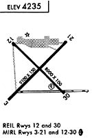
Runways
Runway Summary
| Runways: | 08/26 12/30 |
| Longest Runway: | 08/26 is 10002 ft (3049 m) long |
| Runways with an Instrument Approach: |
ENV Airport Runway Details
| Runway 08/26 | 10002 ft x 150 ft (3049 m x 46 m) | |
| Runway Length Source: | 3RD PARTY SURVEY as of 12/09/2014 | |
| Surface: | Asphalt - Good condition - Saw-cut or plastic grooved | |
| Runway Pavement Class: | 49 /F/C/X/T | |
| Runway Edge Lights: | Medium Intensity | |
Runway Weight Bearing Capacity (in thousands of pounds) |
||
| Single Wheel Landing Gear: | 75.0 | |
| Dual Wheel Landing Gear: | 140.0 | |
| Dual Tandem Wheel Landing Gear: | 208.0 | |
Runway 08 |
Runway 26 |
|
Elevation: |
4229.7 | 4226.4 |
Latitude: |
40-43-08.1861N | 40-43-08.2344N |
Longitude: |
114-02-36.3288W | 114-00-26.4626W |
|
Runway True Alignment: |
090 | 270 |
Glide Path Angle: |
3.0 degrees | 3.0 degrees |
Traffic Pattern: |
Right | |
Runway Markings Type: |
Precision Instrument | Precision Instrument |
Runway Markings Condition: |
Good | Good |
Visual Glide Slope Indicators: |
4-Light PAPI On Left Side Of Runway | 4-Light PAPI On Left Side Of Runway |
REIL: |
Yes | Yes |
Threshold Crossing Height: |
40 | 50 |
Declared Distances |
||
Take Off Run Avbl. (TORA): |
10002 | 10002 |
Take Off Distance Avbl. (TODA): |
10002 | 10002 |
Actual Stop Dist. Avbl. (ASDA): |
10002 | 10002 |
Landing Dist. Avbl. (LDA): |
10002 | 10002 |
| Runway 12/30 | 8002 ft x 100 ft (2439 m x 30 m) | |
| Runway Length Source: | 3RD PARTY SURVEY as of 12/09/2014 | |
| Surface: | Asphalt - Good condition - Saw-cut or plastic grooved | |
| Runway Pavement Class: | 73 /F/C/X/T | |
| Runway Edge Lights: | Medium Intensity | |
Runway Weight Bearing Capacity (in thousands of pounds) |
||
| Single Wheel Landing Gear: | 75.0 | |
| Dual Wheel Landing Gear: | 140.0 | |
| Dual Tandem Wheel Landing Gear: | 180.0 | |
Runway 12 |
Runway 30 |
|
Elevation: |
4236.7 | 4224.3 |
Latitude: |
40-43-34.3349N | 40-42-38.4715N |
Longitude: |
114-02-34.7702W | 114-01-21.2591W |
|
Runway True Alignment: |
135 | 315 |
Glide Path Angle: |
0.0 degrees | 3.0 degrees |
Traffic Pattern: |
Right | Left |
Runway Markings Type: |
Nonprecision Instrument | Nonprecision Instrument |
Runway Markings Condition: |
Good | Good |
Visual Glide Slope Indicators: |
4-Light PAPI On Left Side Of Runway | |
REIL: |
Yes | Yes |
Threshold Crossing Height: |
45 | |
Declared Distances |
||
Take Off Run Avbl. (TORA): |
8002 | 8002 |
Take Off Distance Avbl. (TODA): |
8002 | 8002 |
Actual Stop Dist. Avbl. (ASDA): |
8002 | 8002 |
Landing Dist. Avbl. (LDA): |
8002 | 8002 |
Services
Airframe Repair: |
Major |
Powerplant Repair: |
Major |
Bottled Oxygen: |
None |
Bulk Oxygen: |
None |
Fuel Available: |
100LL, Jet A, MOGAS |
Landing Fees: |
No |
Parking: |
Hangars and tiedowns available |
Other Services: |
Bell Service Center |
Maps & Diagrams
ENV Sectional
Flight Planning
at skyvector.com
at skyvector.com