Location
Latitude: |
66-56-33.2211N (66.942561) |
Longitude: |
156-53-28.9271W (-156.891369) |
Elevation: |
260.0 feet MSL (79 m MSL) |
Magnetic Variation: |
11.8 E (as of April 2024 from WMM2020 model) |
Time Zone: |
UTC -9.0 (Standard Time) UTC -8.0 (Daylight Savings Time) |
From City: |
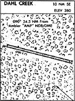
10 N.M. SE of Dahl Creek, Alaska |
Found On: |
Fairbanks Chart |
FAA Region: |
AAL |
Contacts
Manager: |
Publicly owned: |
| ALVIN WERNEKE BOX 55 KOTZEBUE, AK 99752 907-442-3147 |
ALASKA DOT&PF NORTHERN REGION 2301 PEGER RD FAIRBANKS, AK 99709 907-451-2200 |
Operations
Airport Status: |
Operational |
Facility Use: |
Public |
Type: |
Airport |
Activation Date: |
07/1951 |
Control tower: |
No |
Attendance (Months/Days/Hours): |
Months/Days/Hours Unattended |
Boundary ARTCC: |
ZAN (Anchorage) |
Responsible ARTCC: |
ZAN (Anchorage) |
Segmented Circle Indicator: |
Yes |
Traffic Pattern Altitude (MSL): |
1260 feet (384 m) |
NOTAMs Facility: |
OTZ |
NOTAM-D Service: |
Yes |
International Airport of Entry: |
No |
Customs Landing Rights: |
No |
Military Landing Rights: |
Yes |
Civil/Military Joint Use: |
No |
Based Aircraft
Annual Operations (as of 12/31/2022)
| Total Operations: | 225 | |
| Commercial: | 5 | 2.2% |
| Air Taxi: | 220 | 97.8% |
Communications
| CTAF: | 122.700 |
Fixed Based Operators (FBOs) & Fuel
(Click on a business for detail)
Please help us keep this information up to date. This is a FREE SERVICE just like everything else on Airport Guide! If you see that a business needs to be added, modified, or deleted please fill out our Update Form.
To add, modify, or delete a business click here.
Please help us keep this information up to date. This is a FREE SERVICE just like everything else on Airport Guide! If you see that a business needs to be added, modified, or deleted please fill out our Update Form.
Area Code: 907 |
| Business Name | Frequency | Phone | Fuel Grade |
|---|
Flight Service Stations
| Primary | Alternate | |
| FSS on Field: | N | |
| FSS Name (ID): | Kotzebue(OTZ) | Fairbanks (FAI) |
| Frequency: | ||
| Toll Free Phone: | 1-800-478-7460 | 1-866-248-6516 |
Instrument Procedures / Charts
Terminal Procedures are only available for airports in several countries with more being added all the time. If you are looking for a specific country's charts, please send an email to support(at)airportguide.com stating the country name. This will be used to prioritize the implementation.
Navigation Aids (Navaids) near DCK
| Dist (NM) | ID | Morse Code | Name | Type | Freq | True Hdg | Mag Hdg |
|---|---|---|---|---|---|---|---|
| 24.7 | AMF | . _ _ _ . . _ . | Ambler | NDB | 403 | 293 | 281 |
| 75.2 | HSL | . . . . . . . . _ . . | Huslia | VOR-DME | 117.40 | 170 | 158 |
| 76.2 | WLK | . _ _ . _ . . _ . _ | Selawik | VOR-DME | 114.20 | 255 | 244 |
| 95.4 | UTO | . . _ _ _ _ _ | Utopia Creek | NDB-DME | 272 | 125 | 112 |
Nearby Airports with Fuel
| Dist (NM) | Name (Airport IDs) | True Hdg | Mag Hdg | Fuel Grade |
|---|
Notices to Airmen (NOTAMS)
Remarks
| A110-2 | CARIBOU MAY BE ON RY. |
| A110-3 | HIGH TERRAIN NORTH. |
| A110-5 | ARPT NOT MAINTAINED; NO SNOW REMOVAL; RY CONDITION NOT MONITORED. RECOMMEND VISUAL INSPECTION PRIOR TO LANDING. |
| A110-6 | RY 08/26 ALSO USED AS A ROAD. |
| A110-7 | WIND SOCK DAMAGED AND NOT RELIABLE, SEGMENTED CIRCLE AND WIND SOCK ARE OVERGROWN WITH BRUSH AND TREES |
| A33-08/26 | GRASS GROWING ON RY; DIP FORMING APRXLY 250 FT FROM RY 26 THLD & 2 IN WIDE EROSION CHANNELS DEVELOPING FROM CENTER LINE TO SOUTH EDGE; RY NO LONGER MAINTAINED. |
| A5 | NORTHWEST ARCTIC BOROUGH |
| E111 | ESTABD PRIOR TO 1959. |
Runways
Runway Summary
| Runways: | 08/26 |
| Longest Runway: | 08/26 is 4780 ft (1457 m) long |
| Runways with an Instrument Approach: |
DCK Airport Runway Details
| Runway 08/26 | 4780 ft x 75 ft (1457 m x 23 m) | |
| Surface: | Gravel - Good condition - No special surface treatment | |
Runway 08 |
Runway 26 |
|
Latitude: |
66-56-37.4963N | 66-56-28.9459N |
Longitude: |
156-54-27.9123W | 156-52-29.9421W |
Glide Path Angle: |
0.0 degrees | 0.0 degrees |
Traffic Pattern: |
Right | Left |
Object at End: |
BRUSH | BRUSH |
Object Height: |
9 | 11 |
Distance from End: |
0 | 0 |
Object Centerline Offset: |
80 ft. left and right of centerline | 80 ft. left and right of centerline |
Services
Airframe Repair: |
None |
Powerplant Repair: |
None |
Bottled Oxygen: |
None |
Bulk Oxygen: |
None |
Landing Fees: |
No |
Maps & Diagrams
DCK Sectional
Flight Planning
at skyvector.com
at skyvector.com