Location
Latitude: |
38-34-13.3000N (38.570361) |
Longitude: |
090-09-18.3000W (-90.155083) |
Elevation: |
412.9 feet MSL (126 m MSL) |
Magnetic Variation: |
2 W (as of April 2024 from WMM2020 model) |
Time Zone: |
UTC -6.0 (Standard Time) UTC -5.0 (Daylight Savings Time) |
From City: |
01 N.M. E of Cahokia/St. Louis, Illinois |
Found On: |
St Louis Chart |
FAA Region: |
AGL |
Contacts
Manager: |
Publicly owned: |
| SANDRA SHORE 6100 ARCHVIEW DRIVE CAHOKIA, IL 62206-1445 618-337-6060 |
BI-STATE DEVELOPMENT AGENCY 6100 ARCHVIEW DRIVE CAHOKIA, IL 62206-1445 618-337-6060 |
Operations
Airport Status: |
Operational |
Facility Use: |
Public |
Type: |
Airport |
Activation Date: |
04/1940 |
Control tower: |
Yes |
Attendance (Months/Days/Hours): |
Months/Days/Hours ALL/ALL/ALL |
Boundary ARTCC: |
ZKC (Kansas City) |
Responsible ARTCC: |
ZKC (Kansas City) |
Lighting Schedule: |
SEE RMK |
Segmented Circle Indicator: |
No |
Traffic Pattern Altitude (MSL): |
1413 feet (431 m) |
NOTAMs Facility: |
CPS |
NOTAM-D Service: |
Yes |
International Airport of Entry: |
No |
Customs Landing Rights: |
No |
Military Landing Rights: |
Yes |
Civil/Military Joint Use: |
No |
Aircraft Rescue and Firefighting: |
Class IV ARFF Index: A Air Carrier Service: Not Scheduled Certification Date: 08/2008 |
Based Aircraft
| Single Engine: | 85 |
| Multi Engine: | 12 |
| Jet Engine: | 13 |
| GA Helicopters: | 13 |
| Gliders: | 1 |
Annual Operations (as of 12/31/2022)
| Total Operations: | 98219 | |
| Commercial: | 136 | 0.1% |
| Air Taxi: | 11176 | 11.4% |
| GA Local: | 61337 | 62.4% |
| GA Itinerant: | 24915 | 25.4% |
| Military Aircraft: | 655 | 0.7% |
Communications
| CTAF: | 119.925 |
| Unicom: | 122.950 |
| Tower: | DOWNTOWN 119.925 379.3 Hrs: 0630-2200 |
| Clearance Del.: | 118.275 |
| Ground: | 121.8 |
| Approach: | SAINT LOUIS |
| Departure: | SAINT LOUIS |
| ATIS: | 121.45 Hrs: 24 |
| ASOS: | (618-332-0001) |
Fixed Based Operators (FBOs) & Fuel
(Click on a business for detail)
Please help us keep this information up to date. This is a FREE SERVICE just like everything else on Airport Guide! If you see that a business needs to be added, modified, or deleted please fill out our Update Form.
To add, modify, or delete a business click here.
Please help us keep this information up to date. This is a FREE SERVICE just like everything else on Airport Guide! If you see that a business needs to be added, modified, or deleted please fill out our Update Form.
Area Code: 618 |
| Business Name | Frequency | Phone | Fuel Grade |
|---|---|---|---|
| A & S Helicopters, Inc.
Update FBO info |
337-2600 | ||
| Corporate Air Charter
Update FBO info |
Unicom 123.025 | 337-2903 | |
| Downtown Air Service, Inc.
Update FBO info |
Unicom 122.95 | 337-7175 | |
| Fostaire Helicopters
Update FBO info |
Unicom 123.025 | 337-4440 | |
| Helicopters, Inc.
Update FBO info |
Unicom 123.025 | 337-2903 | 100LL, Jet A |
| Ideal Aviation, Inc.
Update FBO info |
Unicom 122.95 | 337-3400 | 100LL, Jet A |
| Midcoast Aviation, Inc.
Update FBO info |
Unicom 122.95 | 337-2100 | 100LL, Jet A |
Flight Service Stations
| Primary | Alternate | |
| FSS on Field: | N | |
| FSS Name (ID): | Saint Louis(STL) | |
| Frequency: | ||
| Toll Free Phone: | 1-800-WX-BRIEF |
Instrument Procedures / Charts
FAA Terminal Procedures valid from 0901Z 03/21/24 to 0901Z 04/18/24.
There are various types of charts available for an airport. They are listed in the Page Type column. Here is a legend for those types:
APD - Airport Diagram
DP - Departure Procedure Charts
HOT - Hot Spots
IAP - Instrument Approach Procedure Charts
MIN - Minimums
STAR - Standard Terminal Arrival Charts
| Page Type | Page Name | Volume | Action Since Last Cycle |
|---|---|---|---|
| APD | AIRPORT DIAGRAM | EC-3 | |
| DP | GATEWAY ONE | EC-3 | |
| DP | GATEWAY ONE[DELIMITER] CONT.1 | EC-3 | |
| DP | LINDBERGH EIGHT | EC-3 | |
| DP | LINDBERGH EIGHT[DELIMITER] CONT.1 | EC-3 | |
| DP | OZARK EIGHT | EC-3 | |
| DP | OZARK EIGHT[DELIMITER] CONT.1 | EC-3 | |
| DP | PLESS FIVE | EC-3 | |
| IAP | ILS OR LOC RWY 30L | EC-3 | Changed |
| IAP | RNAV (GPS) RWY 12R | EC-3 | Changed |
| IAP | RNAV (GPS) RWY 30L | EC-3 | |
| IAP | RNAV (GPS) RWY 30R | EC-3 | |
| MIN | ALTERNATE MINIMUMS | EC-3 | |
| MIN | TAKEOFF MINIMUMS | EC-3 | |
| STAR | BUUDD THREE (RNAV) | EC-3 | |
| STAR | DELMA FOUR (RNAV) | EC-3 | |
| STAR | DIXEE THREE (RNAV) | EC-3 | |
| STAR | FARMR THREE (RNAV) | EC-3 |
Terminal Procedures are only available for airports in several countries with more being added all the time. If you are looking for a specific country's charts, please send an email to support(at)airportguide.com stating the country name. This will be used to prioritize the implementation.
Navigation Aids (Navaids) near CPS
| Dist (NM) | ID | Morse Code | Name | Type | Freq | True Hdg | Mag Hdg |
|---|---|---|---|---|---|---|---|
| 5.4 | CP | _ . _ . . _ _ . | Acore | NDB | 350 | 123 | 125 |
| 14.3 | ST | . . . _ | Zumay | NDB | 404 | 336 | 338 |
| 14.3 | SKE | . . . _ . _ . | Scott | TACAN | 112.20 | 95 | 97 |
| 14.3 | STL | . . . _ . _ . . | St Louis Lambert | VOT | 111.00 | 316 | 318 |
| 14.6 | CSX | _ . _ . . . . _ . . _ | Cardinal | DME | 116.45 | 318 | 320 |
| 15.0 | TOY | _ _ _ _ _ . _ _ | Troy | VORTAC | 116.00 | 47 | 49 |
| 19.5 | FZ | . . _ . _ _ . . | Eaves | NDB | 227 | 289 | 291 |
| 19.8 | BL | _ . . . . _ . . | Belleville | NDB | 362 | 108 | 110 |
| 19.9 | CVM | _ . _ . . . . _ _ _ | Civic Memorial | NDB | 263 | 13 | 15 |
| 19.9 | AL | . _ . _ . . | Alpos | NDB | 218 | 30 | 32 |
| 20.3 | JD | . _ _ _ _ . . | Gooey | NDB | 385 | 105 | 107 |
| 20.4 | LM | . _ . . _ _ | Oblio | NDB | 338 | 312 | 314 |
| 23.2 | STL | . . . _ . _ . . | St Louis | VORTAC | 117.40 | 318 | 320 |
| 23.9 | SUS | . . . . . _ . . . | Spirit Of St Louis | VOT | 112.20 | 283 | 285 |
| 25.0 | FES | . . _ . . . . . | Festus | NDB | 269 | 206 | 208 |
| 29.0 | SU | . . . . . _ | Snoop | NDB | 326 | 278 | 280 |
| 39.0 | FTZ | . . _ . _ _ _ . . | Foristell | VORTAC | 110.80 | 281 | 283 |
| 47.6 | ENL | . _ . . _ . . | Centralia | VORTAC | 115.00 | 100 | 102 |
| 50.1 | PRI | . _ _ . . _ . . . | Perrine | NDB | 367 | 195 | 197 |
| 51.5 | UUV | . . _ . . _ . . . _ | Sullivan | NDB | 356 | 247 | 249 |
Nearby Airports with Fuel
Notices to Airmen (NOTAMS)
Remarks
| A110-1 | WATERFOWL ON & INVOF ARPT. |
| A110-3 | BE ALERT FOR STUDENT TRNG & HEL OPS. |
| A110-5 | ALL TWYS EXCP TWY A4 & B4 PPR ACFT OVER 120000 LBS. |
| A110-6 | SFC CONDS NOT MNTD 2100-0700 LCL. |
| A26 | CLSD TO SKED ACR OPS GTR THAN 9 PSGR SEATS. UNSKED ACR OPS GTR THAN 30 PSGR SEATS RQR 12 HR PPR. |
| A30-05/23 | RWY 05/23 NOT AVBL FOR UNSCHEDULED ACR AT LEAST 31 PASGR SEATS EXCP TAXI. |
| A30-12L/30R | RWY 12L/30R NOT AVBL FOR UNSCHEDULED ACR AT LEAST 31 PASGR SEATS EXCP TAXI. |
| A30-12R/30L | W.B.C. GROSS WT (2S) 160. |
| A37-12R/30L | 200 WITH PPR. |
| A42-05 | SFC MARKINGS FADED. |
| A42-23 | SFC MARKINGS FADED. |
| A81-APT | ACTVT MALSR RWY 30L WHEN ATCT CLSD; REIL RWY 30R - CTAF. HIRL RWY 12R/30L PRESET MED INTST WHEN ATCT CLSD. MIRL RWY 12L & 30R NOT AVBL WHEN ATCT CLSD. PAPI RWY 12R & 30L OPR CONSLY. |
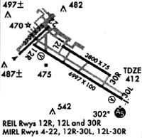
Runways
Runway Summary
| Runways: | 05/23 12L/30R 12R/30L |
| Longest Runway: | 12R/30L is 7002 ft (2134 m) long |
| Runways with an Instrument Approach: | 30L |
CPS Airport Runway Details
| Runway 05/23 | 2799 ft x 75 ft (853 m x 23 m) | |
| Runway Length Source: | 3RD PARTY SURVEY as of 12/07/2011 | |
| Surface: | Asphalt - Fair condition - No special surface treatment | |
| Runway Pavement Class: | 11 /R/C/W/T | |
| Runway Edge Lights: | Medium Intensity | |
Runway Weight Bearing Capacity (in thousands of pounds) |
||
| Single Wheel Landing Gear: | 12.0 | |
Runway 05 |
Runway 23 |
|
Elevation: |
410.0 | 408.6 |
Latitude: |
38-34-20.4835N | 38-34-39.3641N |
Longitude: |
090-10-06.7136W | 090-09-40.9562W |
|
Runway True Alignment: |
047 | 227 |
Glide Path Angle: |
0.0 degrees | 0.0 degrees |
Runway Markings Type: |
Basic | Basic |
Runway Markings Condition: |
Poor | Poor |
Object at End: |
TREE | TOWER |
Object Height: |
58 | 72 |
Object Marked/Lighted?: |
Lighted | |
Distance from End: |
839 | 1647 |
Object Centerline Offset: |
58 ft. right of centerline | 16 ft. right of centerline |
REIL: |
No | No |
Touchdown Lights: |
No | No |
Centerline Lights: |
No | No |
Declared Distances |
||
Take Off Run Avbl. (TORA): |
2799 | 2799 |
Take Off Distance Avbl. (TODA): |
2799 | 2799 |
Actual Stop Dist. Avbl. (ASDA): |
2799 | 2799 |
Landing Dist. Avbl. (LDA): |
2799 | 2799 |
| Runway 12L/30R | 5301 ft x 75 ft (1616 m x 23 m) | |
| Runway Length Source: | 3RD PARTY SURVEY as of 12/07/2011 | |
| Surface: | Asphalt - Fair condition - No special surface treatment | |
| Runway Pavement Class: | 10 /F/D/X/T | |
| Runway Edge Lights: | Medium Intensity | |
Runway Weight Bearing Capacity (in thousands of pounds) |
||
| Single Wheel Landing Gear: | 30.0 | |
| Dual Wheel Landing Gear: | 30.0 | |
Runway 12L |
Runway 30R |
|
Elevation: |
410.0 | 406.5 |
Latitude: |
38-34-25.5888N | 38-33-57.6544N |
Longitude: |
090-09-29.5532W | 090-08-33.0926W |
|
Runway True Alignment: |
122 | 302 |
Glide Path Angle: |
0.0 degrees | 0.0 degrees |
Traffic Pattern: |
Right | |
Runway Markings Type: |
Nonprecision Instrument | Nonprecision Instrument |
Runway Markings Condition: |
Fair | Fair |
Object at End: |
TREE | TREE |
Object Height: |
96 | 72 |
Distance from End: |
3817 | 2664 |
Object Centerline Offset: |
58 ft. right of centerline | 16 ft. right of centerline |
REIL: |
Yes | Yes |
Declared Distances |
||
Take Off Run Avbl. (TORA): |
5300 | 5300 |
Take Off Distance Avbl. (TODA): |
5300 | 5300 |
Actual Stop Dist. Avbl. (ASDA): |
5300 | 5300 |
Landing Dist. Avbl. (LDA): |
5300 | 5300 |
| Runway 12R/30L | 7002 ft x 150 ft (2134 m x 46 m) | |
| Runway Length Source: | 3RD PARTY SURVEY as of 12/07/2011 | |
| Surface: | Asphalt - Fair condition - Saw-cut or plastic grooved | |
| Runway Pavement Class: | 48 /F/D/X/T | |
| Runway Edge Lights: | High Intensity | |
Runway Weight Bearing Capacity (in thousands of pounds) |
||
| Single Wheel Landing Gear: | 65.0 | |
| Dual Wheel Landing Gear: | 95.0 | |
| Dual Tandem Wheel Landing Gear: | 175.0 | |
Runway 12R |
Runway 30L |
|
Elevation: |
412.4 | 408.0 |
Latitude: |
38-34-26.4063N | 38-33-49.5058N |
Longitude: |
090-09-54.2345W | 090-08-39.6457W |
|
Runway True Alignment: |
122 | 302 |
ILS Type: |
ILS | |
Glide Path Angle: |
3.0 degrees | 3.0 degrees |
Traffic Pattern: |
Right | |
Runway Markings Type: |
Precision Instrument | Precision Instrument |
Runway Markings Condition: |
Good | Good |
Object at End: |
TREE | POLE |
Object Height: |
30 | 29 |
Distance from End: |
809 | 1688 |
Object Centerline Offset: |
58 ft. right of centerline | 16 ft. right of centerline |
Visual Glide Slope Indicators: |
4-Light PAPI On Left Side Of Runway | 4-Light PAPI On Left Side Of Runway |
Approach Light System: |
1,400 Foot Medium Intensity Approach Lighting System With Runway Alignment Indicator Lights | |
REIL: |
Yes | No |
Touchdown Lights: |
No | No |
Centerline Lights: |
No | No |
Threshold Crossing Height: |
49 | 53 |
Declared Distances |
||
Take Off Run Avbl. (TORA): |
7002 | 7002 |
Take Off Distance Avbl. (TODA): |
7002 | 7002 |
Actual Stop Dist. Avbl. (ASDA): |
7002 | 7002 |
Landing Dist. Avbl. (LDA): |
7002 | 7002 |
Services
Fuel Available: |
100LL, MOGAS |
Landing Fees: |
No |
Maps & Diagrams
CPS Sectional
Flight Planning
at skyvector.com
at skyvector.com