Location
Latitude: |
41-26-46.1650N (41.446157) |
Longitude: |
085-56-09.7650W (-85.936046) |
Elevation: |
860.0 feet MSL (262 m MSL) |
Magnetic Variation: |
5.4 W (as of April 2024 from WMM2020 model) |
Time Zone: |
UTC -5.0 (Standard Time) UTC -4.0 (Daylight Savings Time) |
From City: |
03 N.M. E of Nappanee, Indiana |
Found On: |
Chicago Chart |
FAA Region: |
AGL |
Contacts
Manager: |
Publicly owned: |
| LLOYD TURNER 24751 US6E NAPPANEE, IN 46550 574-457-6476 |
NAPPANEE BOAC 24751 US6E NAPPANEE, IN 46550 574-773-5027 |
Operations
Airport Status: |
Operational |
Facility Use: |
Public |
Type: |
Airport |
Activation Date: |
02/1968 |
Control tower: |
No |
Attendance (Months/Days/Hours): |
Months/Days/Hours ALL/ALL/0800-1700 |
Boundary ARTCC: |
ZAU (Chicago) |
Responsible ARTCC: |
ZAU (Chicago) |
Lighting Schedule: |
SEE RMK |
Segmented Circle Indicator: |
No |
Traffic Pattern Altitude (MSL): |
1860 feet (567 m) |
NOTAMs Facility: |
HUF |
NOTAM-D Service: |
Yes |
International Airport of Entry: |
No |
Customs Landing Rights: |
No |
Military Landing Rights: |
No |
Civil/Military Joint Use: |
No |
Based Aircraft
| Single Engine: | 16 |
| Multi Engine: | 1 |
| Ultralights: | 1 |
Annual Operations (as of 12/31/2019)
| Total Operations: | 4239 | |
| Air Taxi: | 124 | 2.9% |
| GA Local: | 3204 | 75.6% |
| GA Itinerant: | 911 | 21.5% |
Communications
| CTAF: | 123.000 |
| Unicom: | 123.000 |
| Approach: | SOUTH BEND 132.05 132.05 CHICAGO ARTCC |
| Departure: | SOUTH BEND 132.05 132.05 CHICAGO ARTCC |
- APCH/DEP SVC PRVDD BY CHICAGO ARTCC ON FREQS 135.9/314.0 (GOSHEN RCAG) WHEN SOUTH BEND APCH CTL CLSD.
Fixed Based Operators (FBOs) & Fuel
(Click on a business for detail)
Please help us keep this information up to date. This is a FREE SERVICE just like everything else on Airport Guide! If you see that a business needs to be added, modified, or deleted please fill out our Update Form.
To add, modify, or delete a business click here.
Please help us keep this information up to date. This is a FREE SERVICE just like everything else on Airport Guide! If you see that a business needs to be added, modified, or deleted please fill out our Update Form.
Area Code: 219 |
| Business Name | Frequency | Phone | Fuel Grade |
|---|---|---|---|
| J.B. Air Service
Update FBO info |
Unicom 122.8 | 773-4707 | 100LL |
Flight Service Stations
| Primary | Alternate | |
| FSS on Field: | N | |
| FSS Name (ID): | Terre Haute(HUF) | |
| Frequency: | ||
| Toll Free Phone: | 1-800-WX-BRIEF |
Instrument Procedures / Charts
FAA Terminal Procedures valid from 0901Z 03/21/24 to 0901Z 04/18/24.
There are various types of charts available for an airport. They are listed in the Page Type column. Here is a legend for those types:
APD - Airport Diagram
DP - Departure Procedure Charts
HOT - Hot Spots
IAP - Instrument Approach Procedure Charts
MIN - Minimums
STAR - Standard Terminal Arrival Charts
| Page Type | Page Name | Volume | Action Since Last Cycle |
|---|---|---|---|
| IAP | VOR OR GPS-B | EC-2 | |
| MIN | TAKEOFF MINIMUMS | EC-2 |
Terminal Procedures are only available for airports in several countries with more being added all the time. If you are looking for a specific country's charts, please send an email to support(at)airportguide.com stating the country name. This will be used to prioritize the implementation.
Navigation Aids (Navaids) near C03
| Dist (NM) | ID | Morse Code | Name | Type | Freq | True Hdg | Mag Hdg |
|---|---|---|---|---|---|---|---|
| 6.3 | GSH | _ _ . . . . . . . . | Goshen | VORTAC | 113.70 | 318 | 323 |
| 20.1 | SB | . . . _ . . . | Misha | NDB | 341 | 320 | 325 |
| 23.1 | OLK | _ _ _ . _ . . _ . _ | Webster Lake | VOR | 110.40 | 121 | 127 |
| 24.5 | CPB | _ . _ . . _ _ . _ . . . | Culver | NDB | 391 | 235 | 240 |
| 25.9 | GIJ | _ _ . . . . _ _ _ | Gipper | VORTAC | 115.40 | 318 | 323 |
| 31.5 | IRS | . . . _ . . . . | Sturgis | NDB | 382 | 45 | 51 |
| 33.0 | OXI | _ _ _ _ . . _ . . | Knox | DME | 115.6 | 257 | 262 |
| 34.4 | HAI | . . . . . _ . . | Three Rivers | NDB | 407 | 26 | 32 |
| 36.8 | RWN | . _ . . _ _ _ . | Winamac/Dcmsnd | NDB | 335 | 235 | 240 |
| 37.7 | IUL | . . . . _ . _ . . | La Porte | NDB | 356 | 275 | 280 |
| 39.9 | ANQ | . _ _ . _ _ . _ | Angola | NDB | 347 | 72 | 78 |
| 41.4 | HHG | . . . . . . . . _ _ . | Huntington | NDB | 417 | 148 | 154 |
| 41.4 | IWH | . . . _ _ . . . . | Wabash | NDB | 329 | 171 | 176 |
| 42.3 | VP | . . . _ . _ _ . | Sedly | NDB | 212 | 270 | 275 |
| 42.7 | ELX | . . _ . . _ . . _ | Keeler | VOR-DME | 116.60 | 348 | 353 |
| 43.8 | FWA | . . _ . . _ _ . _ | Fort Wayne Baer | VOT | 111.00 | 129 | 135 |
| 43.9 | FWA | . . _ . . _ _ . _ | Fort Wayne | VORTAC | 117.80 | 129 | 135 |
| 44.2 | BE | _ . . . . | Mally | NDB | 397 | 337 | 342 |
| 44.9 | AZ | . _ _ _ . . | Austn | NDB | 371 | 23 | 29 |
| 45.4 | GW | _ _ . . _ _ | Shenk | NDB | 227 | 100 | 106 |
Nearby Airports with Fuel
Notices to Airmen (NOTAMS)
Remarks
| A110-1 | DEER ON & INVOF ARPT. |
| A110-2 | FOR CD CTC SOUTH BEND APCH AT 574-251-2609. WHEN SOUTH BEND APCH CLSD, FOR CD CTC CHICAGO ARTCC AT 630-906-8921. |
| A40-09/27 | FIRST 670 FT RWY 09 UNLGTD. |
| A57-09 | APCH RATIO 39:1 TO DTHR. |
| A57-27 | APCH RATIO 41:1 TO DTHR. |
| A58-27 | 5 FT CROPS 20 - 200 FT FM RWY END ON CNTRLN. |
| A70-FUEL-10 | 0LL AVBL AFT HR WITH CREDIT CARD. |
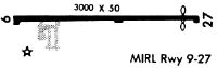
| A81-APT | ACTVT MIRL RWY 09/27 - CTAF. |
Runways
Runway Summary
| Runways: | 09/27 |
| Longest Runway: | 09/27 is 3675 ft (1120 m) long |
| Runways with an Instrument Approach: |
C03 Airport Runway Details
| Runway 09/27 | 3675 ft x 50 ft (1120 m x 15 m) | |
| Runway Length Source: | STATE as of 01/22/2003 | |
| Surface: | Asphalt - Good condition - No special surface treatment | |
| Runway Edge Lights: | Medium Intensity | |
Runway Weight Bearing Capacity (in thousands of pounds) |
||
| Single Wheel Landing Gear: | 7.0 | |
Runway 09 |
Runway 27 |
|
Elevation: |
858.0 | 856.0 |
Latitude: |
41-26-45.9700N | 41-26-46.3600N |
Longitude: |
085-56-33.8900W | 085-55-45.6400W |
|
Runway True Alignment: |
089 | 269 |
Glide Path Angle: |
0.0 degrees | 0.0 degrees |
Traffic Pattern: |
Left | Left |
Runway Markings Type: |
Basic | Basic |
Runway Markings Condition: |
Good | Good |
Object at End: |
ROAD | CROPS |
Object Height: |
13 | 5 |
Distance from End: |
265 | 201 |
Object Centerline Offset: |
0 ft. left and right of centerline | 0 ft. left and right of centerline |
Touchdown Lights: |
No | No |
Centerline Lights: |
No | No |
Threshold Elevation: |
858.0 | 856.0 |
Displaced Threshold: |
250 | 185 |
Threshold Latitude: |
41-26-45.9900N | 41-26-46.3400N |
Threshold Longitude: |
085-56-30.6100W | 085-55-48.0700W |
Services
Fuel Available: |
100LL, Jet A |
Landing Fees: |
No |
Parking: |
Tiedowns available |
Maps & Diagrams
C03 Sectional
Flight Planning
at skyvector.com
at skyvector.com