Location
Latitude: |
42-10-48.3610N (42.1801) |
Longitude: |
077-07-18.1270W (-77.121702) |
Elevation: |
962.4 feet MSL (293 m MSL) |
Magnetic Variation: |
11.3 W (as of April 2024 from WMM2020 model) |
Time Zone: |
UTC -5.0 (Standard Time) UTC -4.0 (Daylight Savings Time) |
From City: |
02 N.M. NW of Corning, New York |
Found On: |
Detroit Chart |
FAA Region: |
AEA |
Contacts
Manager: |
Publicly owned: |
| JAMES DOANE 342 VICTORY HWY RT 415 PAINTED POST, NY 14870 607-962-0053 |
TOWN OF ERWIN IDA 117 WEST WATER STREET PAINTED POST,, NY 14870 607-962-7021 |
Operations
Airport Status: |
Operational |
Facility Use: |
Public |
Type: |
Airport |
Activation Date: |
10/1945 |
Control tower: |
No |
Attendance (Months/Days/Hours): |
Months/Days/Hours ALL/ALL/DALGT |
Boundary ARTCC: |
ZNY (New York) |
Responsible ARTCC: |
ZNY (New York) |
Lighting Schedule: |
SEE RMK |
Segmented Circle Indicator: |
No |
Traffic Pattern Altitude (MSL): |
1962 feet (598 m) |
NOTAMs Facility: |
BUF |
NOTAM-D Service: |
Yes |
International Airport of Entry: |
No |
Customs Landing Rights: |
No |
Military Landing Rights: |
No |
Civil/Military Joint Use: |
No |
Based Aircraft
| Single Engine: | 28 |
| Multi Engine: | 1 |
| GA Helicopters: | 1 |
Annual Operations (as of 08/26/2021)
| Total Operations: | 9025 | |
| Air Taxi: | 25 | 0.3% |
| GA Local: | 7500 | 83.1% |
| GA Itinerant: | 1500 | 16.6% |
Communications
| CTAF: | 122.800 |
| Unicom: | 122.800 |
Fixed Based Operators (FBOs) & Fuel
(Click on a business for detail)
Please help us keep this information up to date. This is a FREE SERVICE just like everything else on Airport Guide! If you see that a business needs to be added, modified, or deleted please fill out our Update Form.
To add, modify, or delete a business click here.
Please help us keep this information up to date. This is a FREE SERVICE just like everything else on Airport Guide! If you see that a business needs to be added, modified, or deleted please fill out our Update Form.
Area Code: 607 |
| Business Name | Frequency | Phone | Fuel Grade |
|---|---|---|---|
| Costa Flying Service
Update FBO info |
Unicom 122.8 | 962-0053 | 100LL |
Flight Service Stations
| Primary | Alternate | |
| FSS on Field: | N | |
| FSS Name (ID): | Buffalo(BUF) | |
| Frequency: | ||
| Toll Free Phone: | 1-800-WX-BRIEF |
Instrument Procedures / Charts
Terminal Procedures are only available for airports in several countries with more being added all the time. If you are looking for a specific country's charts, please send an email to support(at)airportguide.com stating the country name. This will be used to prioritize the implementation.
Navigation Aids (Navaids) near 7N1
| Dist (NM) | ID | Morse Code | Name | Type | Freq | True Hdg | Mag Hdg |
|---|---|---|---|---|---|---|---|
| 6.7 | ULW | . . _ . _ . . . _ _ | Elmira | VOR-DME | 109.65 | 140 | 151 |
| 16.3 | ALP | . _ . _ . . . _ _ . | Alpine | NDB | 245 | 77 | 88 |
| 28.0 | PYA | . _ _ . _ . _ _ . _ | Penn Yan | NDB | 260 | 5 | 16 |
| 32.0 | SFK | . . . . . _ . _ . _ | Stonyfork | VOR-DME | 108.60 | 204 | 215 |
| 34.9 | ITH | . . _ . . . . | Ithaca | DME | 111.8 | 57 | 69 |
| 36.7 | IT | . . _ | Vrnah | NDB | 266 | 65 | 77 |
| 39.4 | ELZ | . . _ . . _ _ . . | Wellsville | DME | 115.85 | 262 | 273 |
| 43.8 | CFB | _ . _ . . . _ . _ . . . | Binghamton | VOR-DME | 112.20 | 91 | 103 |
| 47.7 | GEE | _ _ . . . | Geneseo | VOR-DME | 108.20 | 325 | 336 |
| 52.8 | FQM | . . _ . _ _ . _ _ _ | Williamsport | VOR-DME | 114.40 | 162 | 173 |
| 54.3 | LYS | . _ . . _ . _ _ . . . | Olean | NDB | 360 | 276 | 287 |
| 54.9 | BG | _ . . . _ _ . | Smite | NDB | 332 | 94 | 106 |
| 55.1 | SLT | . . . . _ . . _ | Slate Run | VORTAC | 113.90 | 223 | 234 |
| 57.2 | PIX | . _ _ . . . _ . . _ | Picture Rocks | NDB | 344 | 161 | 172 |
| 57.4 | AVN | . _ . . . _ _ . | Avon | NDB | 344 | 330 | 341 |
| 61.3 | ROC | . _ . _ _ _ _ . _ . | Rochester | VOR-DME | 110.00 | 336 | 347 |
| 68.0 | GGT | _ _ . _ _ . _ | Georgetown | TACAN | 117.80 | 57 | 69 |
| 70.8 | BFD | _ . . . . . _ . _ . . | Bradford | DME | 116.6 | 251 | 262 |
| 71.4 | SYR | . . . _ . _ _ . _ . | Syracuse | VORTAC | 117.00 | 34 | 46 |
| 72.4 | MIP | _ _ . . . _ _ . | Milton | VORTAC | 109.20 | 163 | 174 |
Nearby Airports with Fuel
Notices to Airmen (NOTAMS)
Remarks
| A11 | MS. RITA MCCARTHY IS CONTACT PERSON. |
| A110-1 | FOR CD CTC NEW YORK ARTCC AT 631-468-1425. |
| A16 | MANAGER CELL PHONE NUMBER IS (607) 731-8372 |
| A81-APT | ACTVT MIRL RWY 13/31 & REIL RWY 13 & 31 - CTAF. |
| A81-BCN | ACTVT ROTG BCN - CTAF. |
| E111 | EXISTED PRIOR TO 1959. |
Runways
Runway Summary
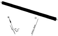
| Runways: | 13/31 |
| Longest Runway: | 13/31 is 3269 ft (996 m) long |
| Runways with an Instrument Approach: |
7N1 Airport Runway Details
| Runway 13/31 | 3269 ft x 75 ft (996 m x 23 m) | |
| Runway Length Source: | 3RD PARTY SURVEY as of 05/10/2010 | |
| Surface: | Asphalt - Excellent condition - No special surface treatment | |
| Runway Edge Lights: | Medium Intensity | |
Runway Weight Bearing Capacity (in thousands of pounds) |
||
| Single Wheel Landing Gear: | 30.0 | |
Runway 13 |
Runway 31 |
|
Elevation: |
962.3 | 956.9 |
Latitude: |
42-10-55.8657N | 42-10-40.8548N |
Longitude: |
077-07-37.3475W | 077-06-58.9075W |
|
Runway True Alignment: |
118 | 298 |
Glide Path Angle: |
0.0 degrees | 0.0 degrees |
Traffic Pattern: |
Right | Left |
Runway Markings Type: |
Nonprecision Instrument | Nonprecision Instrument |
Runway Markings Condition: |
Fair | Fair |
Object at End: |
TREE | TREES |
Object Height: |
43 | 55 |
Distance from End: |
296 | 229 |
Object Centerline Offset: |
196 ft. left of centerline | 151 ft. right of centerline |
REIL: |
Yes | Yes |
Touchdown Lights: |
No | No |
Centerline Lights: |
No | No |
Declared Distances |
||
Take Off Run Avbl. (TORA): |
3269 | 3269 |
Take Off Distance Avbl. (TODA): |
3269 | 3269 |
Actual Stop Dist. Avbl. (ASDA): |
3224 | 3269 |
Landing Dist. Avbl. (LDA): |
3224 | 3224 |
Services
Airframe Repair: |
Major |
Powerplant Repair: |
Major |
Bottled Oxygen: |
None |
Bulk Oxygen: |
None |
Fuel Available: |
100LL, Jet A |
Landing Fees: |
No |
Parking: |
Hangars and tiedowns available |
Maps & Diagrams
7N1 Sectional
Flight Planning
at skyvector.com
at skyvector.com