Location
Latitude: |
40-16-42.2900N (40.278414) |
Longitude: |
110-03-04.9580W (-110.051377) |
Elevation: |
5176.1 feet MSL (1578 m MSL) |
Magnetic Variation: |
10.1 E (as of April 2024 from WMM2020 model) |
Time Zone: |
UTC -7.0 (Standard Time) UTC -6.0 (Daylight Savings Time) |
From City: |
03 N.M. SW of Roosevelt, Utah |
Found On: |
Salt Lake City Chart |
FAA Region: |
ANM |
Contacts
Manager: |
Publicly owned: |
| KIRBY WOLFINJER 255 S. STATE ST. ROOSEVELT, UT 84066 435-722-5001 |
CITY OF ROOSEVELT 255 S. STATE ST. ROOSEVELT, UT 84066 435-722-5001 |
Operations
Airport Status: |
Operational |
Facility Use: |
Public |
Type: |
Airport |
Activation Date: |
10/1975 |
Control tower: |
No |
Attendance (Months/Days/Hours): |
Months/Days/Hours Unattended |
Boundary ARTCC: |
ZLC (Salt Lake City) |
Responsible ARTCC: |
ZLC (Salt Lake City) |
Lighting Schedule: |
SEE RMK |
Segmented Circle Indicator: |
Yes |
Traffic Pattern Altitude (MSL): |
6176 feet (1882 m) |
NOTAMs Facility: |
CDC |
NOTAM-D Service: |
Yes |
International Airport of Entry: |
No |
Customs Landing Rights: |
No |
Military Landing Rights: |
Yes |
Civil/Military Joint Use: |
No |
Based Aircraft
| Single Engine: | 20 |
| Multi Engine: | 1 |
Annual Operations (as of 09/17/2023)
| Total Operations: | 5219 | |
| Air Taxi: | 60 | 1.1% |
| GA Local: | 1557 | 29.8% |
| GA Itinerant: | 3602 | 69.0% |
Communications
| CTAF: | 122.800 |
| Unicom: | 122.800 |
| AWOS-3P: | 118.975 (435-722-4201) |
- COMMUNICATIONS PRVDD BY CEDAR CITY RADIO ON FREQS 122.1R/112.7T (MYTON RCO).
- APCH/DEP CTL SVC PRVDD BY SALT LAKE ARTCC (ZLC) ON 135.775/257.7 (FAIRFIELD RCAG).
Fixed Based Operators (FBOs) & Fuel
(Click on a business for detail)
Please help us keep this information up to date. This is a FREE SERVICE just like everything else on Airport Guide! If you see that a business needs to be added, modified, or deleted please fill out our Update Form.
To add, modify, or delete a business click here.
Please help us keep this information up to date. This is a FREE SERVICE just like everything else on Airport Guide! If you see that a business needs to be added, modified, or deleted please fill out our Update Form.
Area Code: 435 |
| Business Name | Frequency | Phone | Fuel Grade |
|---|---|---|---|
| Roosevelt Airport
Update FBO info |
722-4741, after hours call pager at 646-1229 | 100LL |
Flight Service Stations
| Primary | Alternate | |
| FSS on Field: | N | |
| FSS Name (ID): | Cedar City(CDC) | |
| Frequency: | ||
| Toll Free Phone: | 1-800-WX-BRIEF |
Instrument Procedures / Charts
FAA Terminal Procedures valid from 0901Z 03/21/24 to 0901Z 04/18/24.
There are various types of charts available for an airport. They are listed in the Page Type column. Here is a legend for those types:
APD - Airport Diagram
DP - Departure Procedure Charts
HOT - Hot Spots
IAP - Instrument Approach Procedure Charts
MIN - Minimums
STAR - Standard Terminal Arrival Charts
| Page Type | Page Name | Volume | Action Since Last Cycle |
|---|---|---|---|
| IAP | RNAV (GPS) RWY 25 | SW-4 | |
| IAP | VOR-A | SW-4 | |
| MIN | TAKEOFF MINIMUMS | SW-4 |
Terminal Procedures are only available for airports in several countries with more being added all the time. If you are looking for a specific country's charts, please send an email to support(at)airportguide.com stating the country name. This will be used to prioritize the implementation.
Navigation Aids (Navaids) near 74V
| Dist (NM) | ID | Morse Code | Name | Type | Freq | True Hdg | Mag Hdg |
|---|---|---|---|---|---|---|---|
| 8.5 | MTU | _ _ _ . . _ | Myton | VOR-DME | 112.70 | 204 | 194 |
| 26.2 | VEL | . . . _ . . _ . . | Vernal | VOR-DME | 108.20 | 76 | 66 |
| 51.8 | PUC | . _ _ . . . _ _ . _ . | Carbon | VOR-DME | 115.50 | 218 | 208 |
| 68.1 | FBR | . . _ . _ . . . . _ . | Fort Bridger | VOR-DME | 114.45 | 345 | 335 |
| 74.9 | EVW | . . . . _ . _ _ | Evanston | VOR-DME | 109.60 | 323 | 313 |
| 76.6 | PVU | . _ _ . . . . _ . . _ | Provo | VOR-DME | 108.40 | 267 | 257 |
| 86.5 | FFU | . . _ . . . _ . . . _ | Fairfield | VORTAC | 116.60 | 270 | 260 |
| 91.7 | OCS | _ _ _ _ . _ . . . . | Rock Springs | VOR-DME | 116.00 | 30 | 20 |
| 92.2 | SLC | . . . . _ . . _ . _ . | Salt Lake City | VOT | 111.00 | 289 | 279 |
| 92.4 | OAB | _ _ _ . _ _ . . . | Moab | VOR-DME | 109.80 | 171 | 161 |
| 93.4 | JNC | . _ _ _ _ . _ . _ . | Grand Junction | VOR-DME | 112.40 | 141 | 131 |
| 94.4 | TCH | _ _ . _ . . . . . | Wasatch | VORTAC | 116.80 | 291 | 281 |
| 98.3 | EKR | . _ . _ . _ . | Meeker | VOR-DME | 115.20 | 96 | 86 |
Nearby Airports with Fuel
Notices to Airmen (NOTAMS)
Remarks
| A14 | PUBLIC WORKS DIR/ARPT MGR. |
| A70-FUEL-10 | 0LL 24 HR SELF SVC. |
| A81-APT | ACTVT & INCR INTST REIL RWY 07 & 25; MIRL RWY 7/25 - CTAF. PAPI RWY 07 & 25 ON CONSLY. |
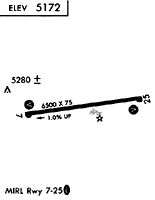
Runways
Runway Summary
| Runways: | 07/25 |
| Longest Runway: | 07/25 is 6501 ft (1982 m) long |
| Runways with an Instrument Approach: |
74V Airport Runway Details
| Runway 07/25 | 6501 ft x 75 ft (1982 m x 23 m) | |
| Runway Length Source: | 3RD PARTY SURVEY as of 03/27/2020 | |
| Surface: | Asphalt - Excellent condition - No special surface treatment | |
| Runway Pavement Class: | 15 /F/C/X/T | |
| Runway Edge Lights: | Medium Intensity | |
Runway Weight Bearing Capacity (in thousands of pounds) |
||
| Single Wheel Landing Gear: | 30.0 | |
| Dual Wheel Landing Gear: | 60.0 | |
Runway 07 |
Runway 25 |
|
Elevation: |
5176.1 | 5110.1 |
Latitude: |
40-16-38.4697N | 40-16-46.1068N |
Longitude: |
110-03-46.5839W | 110-02-23.3313W |
|
Runway True Alignment: |
083 | 263 |
Glide Path Angle: |
3.0 degrees | 3.0 degrees |
Traffic Pattern: |
Left | Left |
Runway Markings Type: |
Nonprecision Instrument | Nonprecision Instrument |
Runway Markings Condition: |
Good | Good |
Visual Glide Slope Indicators: |
4-Light PAPI On Left Side Of Runway | 4-Light PAPI On Left Side Of Runway |
REIL: |
Yes | Yes |
Threshold Crossing Height: |
40 | 40 |
Services
Airframe Repair: |
None |
Powerplant Repair: |
None |
Bottled Oxygen: |
None |
Bulk Oxygen: |
None |
Fuel Available: |
100LL |
Landing Fees: |
No |
Parking: |
Tiedowns available |
Other Services: |
Glider instruction |
Maps & Diagrams
74V Sectional
Flight Planning
at skyvector.com
at skyvector.com