Location
Latitude: |
34-05-18.3000N (34.088417) |
Longitude: |
078-51-53.7000W (-78.864917) |
Elevation: |
99.3 feet MSL (30 m MSL) |
Magnetic Variation: |
9 W (as of April 2024 from WMM2020 model) |
Time Zone: |
UTC -5.0 (Standard Time) UTC -4.0 (Daylight Savings Time) |
From City: |
03 N.M. NE of Loris, South Carolina |
Found On: |
Charlotte Chart |
FAA Region: |
ASO |
Contacts
Manager: |
Publicly owned: |
| JUDI OLMSTEAD 1100 JETPORT RD MYRTLE BEACH, SC 29577 843-839-7359 |
HORRY COUNTY PO BOX 1236 CONWAY, SC 29526 843-448-1580 |
Operations
Airport Status: |
Operational |
Facility Use: |
Public |
Type: |
Airport |
Activation Date: |
07/1961 |
Control tower: |
No |
Attendance (Months/Days/Hours): |
Months/Days/Hours Unattended |
Boundary ARTCC: |
ZJX (Jacksonville) |
Responsible ARTCC: |
ZJX (Jacksonville) |
Segmented Circle Indicator: |
Yes |
Traffic Pattern Altitude (MSL): |
1099 feet (335 m) |
NOTAMs Facility: |
AND |
NOTAM-D Service: |
Yes |
International Airport of Entry: |
No |
Customs Landing Rights: |
No |
Military Landing Rights: |
No |
Civil/Military Joint Use: |
No |
Based Aircraft
| Single Engine: | 2 |
| Multi Engine: | 2 |
Annual Operations (as of 09/12/2023)
| Total Operations: | 1200 | |
| GA Local: | 600 | 50.0% |
| GA Itinerant: | 600 | 50.0% |
Communications
| CTAF: | 122.900 |
| Approach: | MYRTLE BEACH 119.2 119.2 JAX ARTCC |
| Departure: | MYRTLE BEACH 119.2 119.2 JAX ARTCC |
- APCH/DEP SVC PRVDD BY JACKSONVILLE ARTCC ON FREQ 134.375/317.550 (MYRTLE BEACH RCAG) WHEN MYRTLE BEACH APCH CTL CLSD.
Fixed Based Operators (FBOs) & Fuel
(Click on a business for detail)
Please help us keep this information up to date. This is a FREE SERVICE just like everything else on Airport Guide! If you see that a business needs to be added, modified, or deleted please fill out our Update Form.
To add, modify, or delete a business click here.
Please help us keep this information up to date. This is a FREE SERVICE just like everything else on Airport Guide! If you see that a business needs to be added, modified, or deleted please fill out our Update Form.
Area Code: 803 |
| Business Name | Frequency | Phone | Fuel Grade |
|---|
Flight Service Stations
| Primary | Alternate | |
| FSS on Field: | N | |
| FSS Name (ID): | Anderson(AND) | |
| Frequency: | ||
| Toll Free Phone: | 1-800-WX-BRIEF |
Instrument Procedures / Charts
FAA Terminal Procedures valid from 0901Z 03/21/24 to 0901Z 04/18/24.
There are various types of charts available for an airport. They are listed in the Page Type column. Here is a legend for those types:
APD - Airport Diagram
DP - Departure Procedure Charts
HOT - Hot Spots
IAP - Instrument Approach Procedure Charts
MIN - Minimums
STAR - Standard Terminal Arrival Charts
| Page Type | Page Name | Volume | Action Since Last Cycle |
|---|---|---|---|
| IAP | GPS RWY 26 | SE-2 | |
| MIN | TAKEOFF MINIMUMS | SE-2 |
Terminal Procedures are only available for airports in several countries with more being added all the time. If you are looking for a specific country's charts, please send an email to support(at)airportguide.com stating the country name. This will be used to prioritize the implementation.
Navigation Aids (Navaids) near 5J9
| Dist (NM) | ID | Morse Code | Name | Type | Freq | True Hdg | Mag Hdg |
|---|---|---|---|---|---|---|---|
| 13.4 | CPC | _ . _ . . _ _ . _ . _ . | Camp | NDB | 227 | 34 | 43 |
| 17.9 | CRE | _ . _ . . _ . . | Grand Strand | VORTAC | 114.40 | 156 | 165 |
| 20.6 | HYW | . . . . _ . _ _ . _ _ | Horry | NDB | 370 | 219 | 228 |
| 24.0 | MAO | _ _ . _ _ _ _ | Marion | NDB | 388 | 284 | 293 |
| 30.6 | JB | . _ _ _ _ . . . | Jigel | NDB | 384 | 333 | 342 |
| 31.6 | TGQ | _ _ _ . _ _ . _ | Elizabethtown | NDB | 398 | 33 | 42 |
| 32.7 | LBT | . _ . . _ . . . _ | Lumberton | VOR | 110.00 | 343 | 352 |
| 33.0 | RSY | . _ . . . . _ . _ _ | Robeson | NDB | 359 | 342 | 351 |
| 33.1 | DLC | _ . . . _ . . _ . _ . | Dillon | NDB | 274 | 311 | 320 |
| 39.3 | HEK | . . . . . _ . _ | Stuckey | NDB | 236 | 236 | 245 |
| 40.3 | FLO | . . _ . . _ . . _ _ _ | Florence | VORTAC | 115.20 | 282 | 291 |
| 44.9 | CLB | _ . _ . . _ . . _ . . . | Carolina Beach | NDB | 216 | 88 | 97 |
| 47.0 | CFY | _ . _ . . . _ . _ . _ _ | Evans | NDB | 420 | 252 | 261 |
| 48.1 | ME | _ _ . | Maxtn | NDB | 257 | 323 | 332 |
| 49.3 | FL | . . _ . . _ . . | Alcot | NDB | 335 | 276 | 285 |
| 50.0 | IL | . . . _ . . | Airli | NDB | 281 | 82 | 91 |
| 50.5 | PHH | . _ _ . . . . . . . . . | Andrews | NDB | 255 | 221 | 230 |
| 51.6 | ILM | . . . _ . . _ _ | Wilmington | VORTAC | 117.00 | 71 | 80 |
| 51.7 | GGE | _ _ . _ _ . . | Georgetown | NDB | 242 | 206 | 215 |
| 53.6 | BES | _ . . . . . . . | Bennettsville | NDB | 230 | 306 | 315 |
Nearby Airports with Fuel
Notices to Airmen (NOTAMS)
Remarks
| A110*G | THIS AIRPORT HAS BEEN SURVEYED BY THE NATIONAL GEODETIC SURVEY. |
| A110-1 | 30 FT POWER LINE 180 FT SOUTH OF RWY 8-26. |
| A110-2 | BIRDS ON AND INVOF ARPT. |
| A110-3 | FOR CD CTC MYRTLE BEACH APCH AT 843-477-2727 OR 843-477-2704, WHEN APCH CLSD CTC JACKSONVILLE ARTCC AT 904-845-1592. |
| A57-08 | RWY 08 ST-IN APPR 21:1 TO DSP THR DUE TO 17' ROADWAY BOTH SIDES OF CENTERLINE; 358' FROM DSP THR. 50FT TREES 175' R AND AIRCRAFT ACTIVITY APRON 150' L LOCATED PARALLEL TO RWY. |
| A58-08 | RWY 08 ROADWAY AND 50FT TREES 150' TO 175' R;DIST 0 TO 200 FT FROM RWY. AIRCRAFT ACTIVITY APRON 150FT R, DIST 0 TO 125' FROM RWY. |
| E111 | VFR USE ONLY |
Runways
Runway Summary
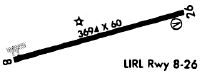
| Runways: | 08/26 |
| Longest Runway: | 08/26 is 3694 ft (1126 m) long |
| Runways with an Instrument Approach: |
5J9 Airport Runway Details
| Runway 08/26 | 3694 ft x 60 ft (1126 m x 18 m) | |
| Runway Length Source: | NGS as of 12/08/1997 | |
| Surface: | Asphalt - Good condition - No special surface treatment | |
| Runway Edge Lights: | Low Intensity | |
Runway Weight Bearing Capacity (in thousands of pounds) |
||
| Single Wheel Landing Gear: | 8.0 | |
Runway 08 |
Runway 26 |
|
Elevation: |
99.2 | 99.3 |
Latitude: |
34-05-13.1241N | 34-05-23.4214N |
Longitude: |
078-52-14.8035W | 078-51-32.6646W |
|
Runway True Alignment: |
074 | 254 |
Glide Path Angle: |
0.0 degrees | 3.5 degrees |
Traffic Pattern: |
Left | Left |
Runway Markings Type: |
Basic | Basic |
Runway Markings Condition: |
Good | Good |
Object at End: |
ROAD | TREES |
Object Height: |
17 | 86 |
Distance from End: |
200 | 1759 |
Object Centerline Offset: |
0 ft. left and right of centerline | 10 ft. right of centerline |
Visual Glide Slope Indicators: |
2-Box SAVASI On Left Side Of Runway | |
Threshold Crossing Height: |
38 | |
Threshold Elevation: |
99.2 | |
Displaced Threshold: |
200 | |
Threshold Latitude: |
34-05-13.6800N | |
Threshold Longitude: |
078-52-12.5200W |
Services
Powerplant Repair: |
None |
Bottled Oxygen: |
None |
Bulk Oxygen: |
None |
Fuel Available: |
100LL, Jet A |
Landing Fees: |
No |
Parking: |
Hangars and tiedowns available |
Maps & Diagrams
5J9 Sectional
Flight Planning
at skyvector.com
at skyvector.com