Location
Latitude: |
38-55-51.9400N (38.931094) |
Longitude: |
094-53-05.3200W (-94.884811) |
Elevation: |
1024.0 feet MSL (312 m MSL) |
Magnetic Variation: |
1.4 E (as of April 2024 from WMM2020 model) |
Time Zone: |
UTC -6.0 (Standard Time) UTC -5.0 (Daylight Savings Time) |
From City: |
04 N.M. NW of Olathe, Kansas |
Found On: |
Kansas City Chart |
FAA Region: |
ACE |
Contacts
Manager: |
Privately owned: |
| MIKE WILLIAMS 25900 COLLEGE BLVD. OLATHE, KS 66061 913-782-5176 |
BROGDEN AVIATION LLC 25900 COLLEGE BLVD. OLATHE, KS 66061 913-782-5176 |
Operations
Airport Status: |
Operational |
Facility Use: |
Public |
Type: |
Airport |
Activation Date: |
10/1967 |
Control tower: |
No |
Attendance (Months/Days/Hours): |
Months/Days/Hours UNATNND |
Boundary ARTCC: |
ZKC (Kansas City) |
Responsible ARTCC: |
ZKC (Kansas City) |
Segmented Circle Indicator: |
No |
Traffic Pattern Altitude (MSL): |
2024 feet (617 m) |
NOTAMs Facility: |
COU |
NOTAM-D Service: |
Yes |
Based Aircraft
| Single Engine: | 3 |
Annual Operations (as of 08/31/2021)
| Total Operations: | 1100 | |
| GA Local: | 1000 | 90.9% |
| GA Itinerant: | 100 | 9.1% |
Communications
| CTAF: | 122.700 |
| Unicom: | 122.700 |
Fixed Based Operators (FBOs) & Fuel
(Click on a business for detail)
Please help us keep this information up to date. This is a FREE SERVICE just like everything else on Airport Guide! If you see that a business needs to be added, modified, or deleted please fill out our Update Form.
To add, modify, or delete a business click here.
Please help us keep this information up to date. This is a FREE SERVICE just like everything else on Airport Guide! If you see that a business needs to be added, modified, or deleted please fill out our Update Form.
Area Code: 913 |
| Business Name | Frequency | Phone | Fuel Grade |
|---|---|---|---|
| Wings Unlimited, Inc.
Update FBO info |
782-5176 |
Flight Service Stations
| Primary | Alternate | |
| FSS on Field: | N | |
| FSS Name (ID): | Columbia(COU) | |
| Frequency: | ||
| Toll Free Phone: | 1-800-WX-BRIEF |
Instrument Procedures / Charts
Terminal Procedures are only available for airports in several countries with more being added all the time. If you are looking for a specific country's charts, please send an email to support(at)airportguide.com stating the country name. This will be used to prioritize the implementation.
Navigation Aids (Navaids) near 51K
| Dist (NM) | ID | Morse Code | Name | Type | Freq | True Hdg | Mag Hdg |
|---|---|---|---|---|---|---|---|
| 8.8 | OJC | _ _ _ . _ _ _ _ . _ . | Johnson County | VOR-DME | 113.00 | 128 | 127 |
| 12.6 | JZ | . _ _ _ _ _ . . | Newbn | NDB | 338 | 265 | 264 |
| 12.7 | PK | . _ _ . _ . _ | Herbb | NDB | 420 | 147 | 146 |
| 13.2 | GQ | _ _ . _ _ . _ | Norge | NDB | 517 | 53 | 52 |
| 17.6 | RIS | . _ . . . . . . | Riverside | VOR-DME | 111.40 | 49 | 48 |
| 17.6 | MKC | _ _ _ . _ _ . _ . | Kansas City Downtown | VOT | 108.60 | 49 | 48 |
| 18.5 | DO | _ . . _ _ _ | Dotte | NDB | 359 | 19 | 18 |
| 22.3 | MCI | _ _ _ . _ . . . | Kansas City | VORTAC | 113.25 | 17 | 16 |
| 32.6 | FO | . . _ . _ _ _ | Riply | NDB | 326 | 265 | 263 |
| 33.3 | TOP | _ _ _ _ . _ _ . | Topeka | VORTAC | 117.80 | 291 | 289 |
| 36.2 | FOE | . . _ . _ _ _ . | Forbes | TACAN | 111.60 | 271 | 269 |
| 36.5 | FOE | . . _ . _ _ _ . | Forbes | VOT | 111.00 | 272 | 270 |
| 36.6 | ANX | . _ _ . _ . . _ | Napoleon | VORTAC | 114.00 | 74 | 73 |
| 39.1 | TO | _ _ _ _ | Biloy | NDB | 521 | 287 | 285 |
| 43.7 | BUM | _ . . . . . _ _ _ | Butler | VORTAC | 115.90 | 154 | 153 |
| 44.7 | ST | . . . _ | Tario | NDB | 260 | 358 | 357 |
| 54.5 | UKL | . . _ _ . _ . _ . . | Boyd | NDB | 245 | 226 | 224 |
| 57.2 | AZN | . _ _ _ . . _ . | Amazon | NDB | 233 | 358 | 357 |
| 60.6 | RBA | . _ . _ . . . . _ | Robinson | DME | 108.2 | 335 | 333 |
| 61.8 | STJ | . . . _ . _ _ _ | St Joseph | VORTAC | 115.50 | 358 | 357 |
Nearby Airports with Fuel
Notices to Airmen (NOTAMS)
Remarks
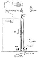
| A110-10 | FOR CD CTC KANSAS CITY APCH AT 816-329-2710. |
| A110-6 | GOLF COURSE N END OF RY 17 CAN BE MISTAKEN FOR ARPT. |
| A110-8 | WILDLIFE ON & INVOF ARPT. |
| A110-9 | TREES BOTH SIDES OF RWY. |
| A42-17 | RY OUTLINED WITH CONC PADS AT 300 FT INTRVLS. RY ENDS MKD WITH YELLOW CONC PADS. |
Runways
Runway Summary
| Runways: | 17/35 |
| Longest Runway: | 17/35 is 2440 ft (744 m) long |
| Runways with an Instrument Approach: |
51K Airport Runway Details
| Runway 17/35 | 2440 ft x 75 ft (744 m x 23 m) | |
| Surface: | Turf - Good condition - No special surface treatment | |
Runway 17 |
Runway 35 |
|
Elevation: |
998.0 | 1020.0 |
Latitude: |
38-56-03.9800N | 38-55-39.9000N |
Longitude: |
094-53-06.0300W | 094-53-04.6100W |
|
Runway True Alignment: |
177 | 357 |
Glide Path Angle: |
0.0 degrees | 0.0 degrees |
Traffic Pattern: |
Left | Left |
Object at End: |
TREES | TREES |
Object Height: |
42 | 72 |
Distance from End: |
94 | 145 |
Object Centerline Offset: |
88 ft. left of centerline | 84 ft. right of centerline |
Services
Airframe Repair: |
Major |
Powerplant Repair: |
Major |
Bottled Oxygen: |
None |
Bulk Oxygen: |
None |
Fuel Available: |
100LL |
Landing Fees: |
No |
Parking: |
Tiedowns available |
Maps & Diagrams
51K Sectional
Flight Planning
at skyvector.com
at skyvector.com