Location
Latitude: |
27-38-33.3500N (27.642597) |
Longitude: |
082-31-11.7000W (-82.519917) |
Elevation: |
27.0 feet MSL (8 m MSL) |
Magnetic Variation: |
6 W (as of April 2024 from WMM2020 model) |
Time Zone: |
UTC -5.0 (Standard Time) UTC -4.0 (Daylight Savings Time) |
From City: |
07 N.M. NE of Palmetto, Florida |
Found On: |
Miami Chart |
FAA Region: |
ASO |
Contacts
Manager: |
Privately owned: |
| TOM REEDER 14108 U.S. HIGHWAY 41 NORTH PALMETTO, FL 34221 941-722-9296 |
DFM PROPERTIES, LLC 945 HERITAGE HILLS DECATUR, GA 30033 404-371-3924 |
Operations
Airport Status: |
Operational |
Facility Use: |
Public |
Type: |
Airport |
Activation Date: |
05/1977 |
Control tower: |
No |
Attendance (Months/Days/Hours): |
Months/Days/Hours ALL/SAT/0900-1200 |
Boundary ARTCC: |
ZMA (Miami) |
Responsible ARTCC: |
ZMA (Miami) |
Lighting Schedule: |
SEE RMK |
Segmented Circle Indicator: |
Yes |
Traffic Pattern Altitude (MSL): |
1027 feet (313 m) |
NOTAMs Facility: |
PIE |
NOTAM-D Service: |
Yes |
Based Aircraft
| Single Engine: | 70 |
| Multi Engine: | 1 |
| Ultralights: | 2 |
Annual Operations (as of 12/13/2017)
| Total Operations: | 7100 | |
| GA Local: | 5000 | 70.4% |
| GA Itinerant: | 2000 | 28.2% |
| Military Aircraft: | 100 | 1.4% |
Communications
| CTAF: | 122.900 |
Fixed Based Operators (FBOs) & Fuel
(Click on a business for detail)
Please help us keep this information up to date. This is a FREE SERVICE just like everything else on Airport Guide! If you see that a business needs to be added, modified, or deleted please fill out our Update Form.
To add, modify, or delete a business click here.
Please help us keep this information up to date. This is a FREE SERVICE just like everything else on Airport Guide! If you see that a business needs to be added, modified, or deleted please fill out our Update Form.
Area Code: 941 |
| Business Name | Frequency | Phone | Fuel Grade |
|---|---|---|---|
| Airport Manatee
Update FBO info |
722-9296 | 100LL, Mogas |
Flight Service Stations
| Primary | Alternate | |
| FSS on Field: | N | |
| FSS Name (ID): | Saint Petersburg(PIE) | |
| Frequency: | ||
| Toll Free Phone: | 1-800-WX-BRIEF |
Instrument Procedures / Charts
Terminal Procedures are only available for airports in several countries with more being added all the time. If you are looking for a specific country's charts, please send an email to support(at)airportguide.com stating the country name. This will be used to prioritize the implementation.
Navigation Aids (Navaids) near 48X
| Dist (NM) | ID | Morse Code | Name | Type | Freq | True Hdg | Mag Hdg |
|---|---|---|---|---|---|---|---|
| 13.1 | MCF | _ _ _ . _ . . . _ . | Macdill | TACAN | 111.00 | 1 | 7 |
| 13.2 | AM | . _ _ _ | Picny | NDB | 388 | 354 | 360 |
| 14.3 | SRQ | . . . . _ . _ _ . _ | Sarasota | VOR-DME | 117.00 | 189 | 195 |
| 18.1 | PIE | . _ _ . . . . | St Petersburg | VORTAC | 116.40 | 331 | 337 |
| 19.9 | TPA | _ . _ _ . . _ | Tampa Intl | VOT | 111.00 | 358 | 364 |
| 23.3 | PI | . _ _ . . . | Capok | NDB | 360 | 335 | 341 |
| 26.6 | TP | _ . _ _ . | Cosme | NDB | 368 | 359 | 365 |
| 33.9 | LAL | . _ . . . _ . _ . . | Lakeland | VORTAC | 116.00 | 52 | 58 |
| 35.2 | VNC | . . . _ _ . _ . _ . | Venice | NDB | 206 | 172 | 178 |
| 40.0 | RHZ | . _ . . . . . _ _ . . | Zephyrhills | NDB | 253 | 28 | 34 |
| 51.9 | PGD | . _ _ . _ _ . _ . . | Punta Gorda | VOR | 110.20 | 146 | 152 |
| 74.1 | FM | . . _ . _ _ | Caloo | NDB | 341 | 155 | 161 |
| 77.4 | OR | _ _ _ . _ . | Herny | NDB | 221 | 47 | 53 |
| 77.5 | LBV | . _ . . _ . . . . . . _ | La Belle | VORTAC | 110.40 | 128 | 134 |
| 77.7 | RSW | . _ . . . . . _ _ | Lee County | VORTAC | 114.15 | 149 | 155 |
| 80.0 | LEE | . _ . . . . | Leesburg | NDB | 335 | 27 | 33 |
| 82.8 | ORL | _ _ _ . _ . . _ . . | Orlando | VORTAC | 112.20 | 48 | 54 |
| 93.4 | OCF | _ _ _ _ . _ . . . _ . | Ocala | VORTAC | 113.70 | 9 | 15 |
| 96.2 | SFB | . . . . . _ . _ . . . | Sanford | NDB | 408 | 44 | 50 |
| 97.8 | CYY | _ . _ . _ . _ _ _ . _ _ | Cypress | VOR-DME | 108.60 | 155 | 161 |
Nearby Airports with Fuel
Notices to Airmen (NOTAMS)
Remarks
| A11 | CONTACT PERSON: TOM REEDER: 941-722-9296 |
| A110-1 | BIRDS, WILDLIFE AND DEER ON AND INVOF ARPT. |
| A110-2 | RWY 07/25 FIRST 500 FT EAST END SOFT AFTER HEAVY SEASONAL RAINS. |
| A110-3 | RWY 7/25 SPRINKLERS ACTIVE MON-THU 2000-0500. |
| A110-4 | ARPT CLSD TO TURBINE HOPS INCLG HOVER AND PRACTICE MANUEVERS AT NE FIELD ADJ TO RWY 7/25 EXC BELL JET RANGERS, EMERG. CALL IN ADVN 941-722-9296. |
| A110-5 | FOR CD CTC TAMPA APCH AT 813-878-2528 |
| A14 | AIRPORT PHYSICAL ADDRESS: 14108 U.S. HIGHWAY 41 NORTH; FAX: 941-721-9067 |
| A17 | CALL AMGR FOR AFTER HRS SVC AND CHECK RY CONDITIONS 941-722-9296. |
| A42-07 | RWY 07 & 25 THLDS MKD BY 3 GREEN LGTS AND 1 BUCKET ON EACH SIDE OF RWY. |
| A42-25 | RWY 07 & 25 THLDS MKD BY 3 GREEN LGTS AND 1 BUCKET ON EACH SIDE OF RWY. |
| A55-07 | 8 FT TREES 90-100 FT S OF RY CNTRLN FULL LENGTH. ACFT HANGARS 135 FT L OF CNTRLN FIRST HALF OF RY 07. ACFT PARKED 100 FT R OF CNTRLN FIRST 1/3 OF RY 25. |
| A70-FUEL-10 | 0LL FUEL AVBL DAILY SR-SS. |
| A81-APT | LIRL RWY 7/25 AVBL BY PHONE REQUEST 941-722-9296. |
| E111 | PRVDD VFR; ALL TFC PATTERNS ARE ESTABLISHED ON SOUTH SIDE OF RY & RY CENTERLINE EXTENDED; ARPT OPERATOR ESTABLISHES/MAINTAINS SEGMENTED CIRCLE; WINDSOCK MAINTAINED; AND ARPT MEETS REQUIREMENTS OF STATE FOR PUBLIC USE. |
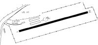
Runways
Runway Summary
| Runways: | 07/25 |
| Longest Runway: | 07/25 is 3120 ft (951 m) long |
| Runways with an Instrument Approach: |
48X Airport Runway Details
| Runway 07/25 | 3120 ft x 100 ft (951 m x 30 m) | |
| Runway Length Source: | OWNER as of 07/17/2012 | |
| Surface: | Turf - Fair condition - No special surface treatment | |
| Runway Edge Lights: | Low Intensity | |
Runway 07 |
Runway 25 |
|
Latitude: |
27-38-29.8000N | 27-38-36.9000N |
Longitude: |
082-31-28.6000W | 082-30-54.8000W |
Glide Path Angle: |
0.0 degrees | 0.0 degrees |
Traffic Pattern: |
Right | Left |
Runway Markings Type: |
Nonstandard (other than numbers only) | Nonstandard (other than numbers only) |
Runway Markings Condition: |
Fair | Fair |
Object at End: |
TREES | BRUSH |
Object Height: |
38 | 12 |
Distance from End: |
745 | 235 |
Object Centerline Offset: |
125 ft. left of centerline | 95 ft. right of centerline |
Services
Airframe Repair: |
None |
Powerplant Repair: |
None |
Bottled Oxygen: |
None |
Bulk Oxygen: |
None |
Fuel Available: |
100LL, Jet A |
Landing Fees: |
No |
Parking: |
Tiedowns available |
Maps & Diagrams
48X Sectional
Flight Planning
at skyvector.com
at skyvector.com