Location
Latitude: |
44-58-40.8000N (44.978) |
Longitude: |
116-17-02.1000W (-116.283917) |
Elevation: |
3908.0 feet MSL (1191 m MSL) |
Magnetic Variation: |
13.2 E (as of April 2024 from WMM2020 model) |
Time Zone: |
UTC -7.0 (Standard Time) UTC -6.0 (Daylight Savings Time) |
From City: |
00 N.M. N of New Meadows, Idaho |
Found On: |
Great Falls Chart |
FAA Region: |
ANM |
Contacts
Manager: |
Publicly owned: |
| IDAHO DIV OF AERONAUTICS BOX 7129 BOISE, ID 83707-1129 208-334-8775 |
STATE OF IDAHO ITD, DIV AERO BOX 7129 BOISE, ID 83707-1129 208-334-8775 |
Operations
Airport Status: |
Operational |
Facility Use: |
Public |
Type: |
Airport |
Control tower: |
No |
Attendance (Months/Days/Hours): |
Months/Days/Hours Unattended |
Boundary ARTCC: |
ZLC (Salt Lake City) |
Responsible ARTCC: |
ZLC (Salt Lake City) |
Segmented Circle Indicator: |
Yes |
Traffic Pattern Altitude (MSL): |
4908 feet (1496 m) |
NOTAMs Facility: |
BOI |
NOTAM-D Service: |
Yes |
Civil/Military Joint Use: |
No |
Based Aircraft
Annual Operations (as of 05/30/2023)
| Total Operations: | 1000 | |
| GA Itinerant: | 1000 | 100.0% |
Communications
| CTAF: | 122.900 |
- COMMUNICATIONS PRVDD BY BOISE RADIO ON FREQ 122.5 (CASCADE RCO).
Fixed Based Operators (FBOs) & Fuel
(Click on a business for detail)
Please help us keep this information up to date. This is a FREE SERVICE just like everything else on Airport Guide! If you see that a business needs to be added, modified, or deleted please fill out our Update Form.
To add, modify, or delete a business click here.
Please help us keep this information up to date. This is a FREE SERVICE just like everything else on Airport Guide! If you see that a business needs to be added, modified, or deleted please fill out our Update Form.
Area Code: 208 |
| Business Name | Frequency | Phone | Fuel Grade |
|---|
Flight Service Stations
| Primary | Alternate | |
| FSS on Field: | N | |
| FSS Name (ID): | Boise(BOI) | |
| Frequency: | ||
| Toll Free Phone: | 1-800-WX-BRIEF |
Instrument Procedures / Charts
Terminal Procedures are only available for airports in several countries with more being added all the time. If you are looking for a specific country's charts, please send an email to support(at)airportguide.com stating the country name. This will be used to prioritize the implementation.
Navigation Aids (Navaids) near 1U4
| Dist (NM) | ID | Morse Code | Name | Type | Freq | True Hdg | Mag Hdg |
|---|---|---|---|---|---|---|---|
| 13.1 | DNJ | _ . . _ . . _ _ _ | Donnelly | VOR-DME | 116.20 | 165 | 152 |
| 65.3 | BKE | _ . . . _ . _ . | Baker City | VOR-DME | 115.30 | 263 | 250 |
| 65.3 | ONO | _ _ _ _ . _ _ _ | Ontario | NDB | 305 | 208 | 195 |
| 65.7 | IDQ | . . _ . . _ _ . _ | Cottonwood | DME | 115.65 | 353 | 340 |
| 74.3 | LGD | . _ . . _ _ . _ . . | La Grande | NDB | 296 | 287 | 274 |
| 82.9 | BO | _ . . . _ _ _ | Ustik | NDB | 359 | 180 | 167 |
| 83.2 | MPA | _ _ . _ _ . . _ | Meridian | NDB | 238 | 187 | 174 |
| 85.4 | BOI | _ . . . _ _ _ . . | Boise | VOT | 116.70 | 178 | 165 |
| 85.6 | BOI | _ . . . _ _ _ . . | Boise | VORTAC | 113.30 | 177 | 164 |
| 87.7 | MQG | _ _ _ _ . _ _ _ . | Nez Perce | VOR-DME | 114.45 | 343 | 330 |
| 93.4 | LKT | . _ . . _ . _ _ | Salmon | VOR-DME | 113.50 | 87 | 74 |
Nearby Airports with Fuel
Notices to Airmen (NOTAMS)
Remarks
| A110-1 | NO WINTER MAINTENANCE. |
| A110-2 | NO LINE OF SIGHT BTN RWY ENDS. |
| A110-3 | FENCE WARNING PANELS INSTALLED ON FENCE, APPROACH TO RY 14. |
| A110-4 | NO TELEPHONE AVBL AT ARPT. |
| A110-5 | FOR CD CTC SALT LAKE ARTCC AT 801-320-2568. |
| A33-14/32 | RWY 14/32 SOUTH HALF 20 FT WIDE GRAVEL STRIP WITH LOOSE ROCKS UP TO 2 INCHES; NORTH HALF SPARSE GRAVEL UP TO 2 INCHES; GRASS MAY BE HIGH. RUNWAY AND TIE DOWN AREA SOFT WHEN WET. |
| A42-14 | 14/32 EDGES & THRS MKD WITH WHITE ROCKS. |
| A52-14 | +4 FT FENCE AT 45 FT ON CTRLN. |
| A52-32 | +17 FT PLINE 400 FT 75 FT R; +21 FT PLINE AT 500 FT ON CNTRLN. |
| E111 | ESTABD PRIOR TO 15 MAY 1959. |
Runways
Runway Summary
| Runways: | 14/32 |
| Longest Runway: | 14/32 is 2400 ft (732 m) long |
| Runways with an Instrument Approach: |
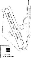
1U4 Airport Runway Details
| Runway 14/32 | 2400 ft x 150 ft (732 m x 46 m) | |
| Surface: | Turf/Gravel - Fair condition - No special surface treatment | |
Runway 14 |
Runway 32 |
|
Latitude: |
44-58-51.5100N | 44-58-30.0500N |
Longitude: |
116-17-09.2400W | 116-16-55.0400W |
Glide Path Angle: |
0.0 degrees | 0.0 degrees |
Traffic Pattern: |
Left | Right |
Object at End: |
FENCE | TREE |
Object Height: |
4 | 25 |
Distance from End: |
0 | 575 |
Object Centerline Offset: |
100 ft. left of centerline | 75 ft. left of centerline |
Services
Airframe Repair: |
None |
Powerplant Repair: |
None |
Bottled Oxygen: |
None |
Bulk Oxygen: |
None |
Fuel Available: |
100LL |
Landing Fees: |
No |
Parking: |
Tiedowns available |
Maps & Diagrams
1U4 Sectional
Flight Planning
at skyvector.com
at skyvector.com