Location
Latitude: |
44-59-11.8000N (44.986611) |
Longitude: |
099-57-10.4000W (-99.952889) |
Elevation: |
2061.8 feet MSL (628 m MSL) |
Magnetic Variation: |
5 E (as of April 2024 from WMM2020 model) |
Time Zone: |
UTC -6.0 (Standard Time) UTC -5.0 (Daylight Savings Time) |
From City: |
01 N.M. S of Gettysburg, South Dakota |
Found On: |
Twin Cities Chart |
FAA Region: |
AGL |
Contacts
Manager: |
Publicly owned: |
| GREG GERBER 109 E COMMERCIAL GETTYSBURG, SD 57442 605-769-0075 |
CITY OF GETTYSBURG 109 E. COMMERCIAL GETTYSBURG, SD 57442 605-765-2733 |
Operations
Airport Status: |
Operational |
Facility Use: |
Public |
Type: |
Airport |
Activation Date: |
12/1946 |
Control tower: |
No |
Attendance (Months/Days/Hours): |
Months/Days/Hours ALL/MON-FRI/DALGT |
Boundary ARTCC: |
ZMP (Minneapolis) |
Responsible ARTCC: |
ZMP (Minneapolis) |
Lighting Schedule: |
SEE RMK |
Segmented Circle Indicator: |
No |
Traffic Pattern Altitude (MSL): |
3062 feet (933 m) |
NOTAMs Facility: |
HON |
NOTAM-D Service: |
Yes |
International Airport of Entry: |
No |
Customs Landing Rights: |
No |
Military Landing Rights: |
Yes |
Civil/Military Joint Use: |
No |
Based Aircraft
| Single Engine: | 10 |
| Multi Engine: | 1 |
Annual Operations (as of 08/08/2023)
| Total Operations: | 6200 | |
| GA Local: | 5600 | 90.3% |
| GA Itinerant: | 600 | 9.7% |
Communications
| CTAF: | 122.800 |
| Unicom: | 122.800 |
| AWOS-3P: | 119.275 (605-765-0132) |
- APCH/DEP SVC PRVDD BY MINNEAPOLIS ARTCC ON FREQS 125.1/269.1 (PIERRE RCAG).
Fixed Based Operators (FBOs) & Fuel
(Click on a business for detail)
Please help us keep this information up to date. This is a FREE SERVICE just like everything else on Airport Guide! If you see that a business needs to be added, modified, or deleted please fill out our Update Form.
To add, modify, or delete a business click here.
Please help us keep this information up to date. This is a FREE SERVICE just like everything else on Airport Guide! If you see that a business needs to be added, modified, or deleted please fill out our Update Form.
Area Code: 605 |
| Business Name | Frequency | Phone | Fuel Grade |
|---|---|---|---|
| Nauman Flying Service
Update FBO info |
Unicom 122.8 | 765-9197 | 100LL |
Flight Service Stations
| Primary | Alternate | |
| FSS on Field: | N | |
| FSS Name (ID): | Huron(HON) | |
| Frequency: | ||
| Toll Free Phone: | 1-800-WX-BRIEF |
Instrument Procedures / Charts
FAA Terminal Procedures valid from 0901Z 03/21/24 to 0901Z 04/18/24.
There are various types of charts available for an airport. They are listed in the Page Type column. Here is a legend for those types:
APD - Airport Diagram
DP - Departure Procedure Charts
HOT - Hot Spots
IAP - Instrument Approach Procedure Charts
MIN - Minimums
STAR - Standard Terminal Arrival Charts
| Page Type | Page Name | Volume | Action Since Last Cycle |
|---|---|---|---|
| IAP | RNAV (GPS) RWY 13 | NC-1 | |
| IAP | RNAV (GPS) RWY 31 | NC-1 | |
| MIN | TAKEOFF MINIMUMS | NC-1 |
Terminal Procedures are only available for airports in several countries with more being added all the time. If you are looking for a specific country's charts, please send an email to support(at)airportguide.com stating the country name. This will be used to prioritize the implementation.
Navigation Aids (Navaids) near 0D8
| Dist (NM) | ID | Morse Code | Name | Type | Freq | True Hdg | Mag Hdg |
|---|---|---|---|---|---|---|---|
| 36.6 | PIR | . _ _ . . . . _ . | Pierre | VORTAC | 113.75 | 194 | 189 |
| 71.8 | ABR | . _ _ . . . . _ . | Aberdeen | VOR-DME | 113.00 | 68 | 64 |
| 72.8 | AB | . _ _ . . . | Reney | NDB | 203 | 70 | 66 |
| 74.9 | DPR | _ . . . _ _ . . _ . | Dupree | VOR-DME | 116.80 | 274 | 268 |
| 76.2 | HO | . . . . _ _ _ | Beady | NDB | 302 | 114 | 110 |
| 77.3 | HON | . . . . _ _ _ _ . | Huron | DME | 117.6 | 114 | 110 |
| 90.3 | ISD | . . . . . _ . . | Winner | VOR | 112.80 | 174 | 169 |
| 92.0 | PHP | . _ _ . . . . . . _ _ . | Philip | VOR-DME | 108.40 | 233 | 227 |
Nearby Airports with Fuel
| Dist (NM) | Name (Airport IDs) | True Hdg | Mag Hdg | Fuel Grade |
|---|---|---|---|---|
| 35.7 | Faulkton Municipal Airport (3FU) |
85 | 81 | 100LL |
| 38.7 | Mobridge Municipal Airport (MBG KMBG MBG) |
330 | 325 | 100LL, Jet A, MOGAS |
| 38.9 | Pierre Regional Airport (PIR KPIR PIR) |
201 | 196 | 100LL, Jet A |
| 50.6 | Miller Municipal Airport (KMKA MKA) |
122 | 118 | 100LL |
| 54.3 | Timber Lake Municipal Airport (D58) |
298 | 292 | 100LL |
| 70.3 | Aberdeen Regional Airport (ABR KABR ABR) |
66 | 62 | 100LL, Jet A |
| 78.1 | Chamberlain Municipal Airport (9V9) |
159 | 155 | 100LL, Jet A |
| 81.9 | Huron Regional Airport (HON KHON HON) |
115 | 111 | 100LL, Jet A |
| 90.1 | Philip Airport (PHP KPHP PHP) |
231 | 225 | 100LL |
| 90.8 | Napoleon Municipal Airport (5B5) |
5 | 0 | 100LL |
| 95.4 | Clark County Airport (8D7) |
92 | 89 | 100LL, Jet A |
Notices to Airmen (NOTAMS)
Remarks
| A110-1 | WILDLIFE ON AND INVOF ARPT. |
| A110-2 | FUEL AVBL 24 HR WITH CREDIT CARD. |
| A110-3 | FOR CD CTC MINNEAPOLIS ARTCC AT 651-463-5588. |
| A42-04 | 04/22 MKD WITH BLACK AND W CONES. |
| A81-APT | ACTVT PAPI RWY 13 & 31; LIRL RWY 13/31 - CTAF. |
| A82 | AUTOMATED UNICOM. |
Runways
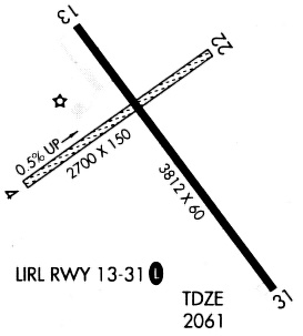
Runway Summary
| Runways: | 04/22 13/31 |
| Longest Runway: | 13/31 is 4400 ft (1341 m) long |
| Runways with an Instrument Approach: |
0D8 Airport Runway Details
| Runway 04/22 | 2485 ft x 155 ft (757 m x 47 m) | |
| Runway Length Source: | 3RD PARTY SURVEY as of 07/21/2011 | |
| Surface: | Turf - Good condition - No special surface treatment | |
Runway 04 |
Runway 22 |
|
Elevation: |
2049.1 | 2061.6 |
Latitude: |
44-59-08.0547N | 44-59-22.7138N |
Longitude: |
099-57-32.3731W | 099-57-04.6496W |
|
Runway True Alignment: |
053 | 233 |
Glide Path Angle: |
0.0 degrees | 0.0 degrees |
Traffic Pattern: |
Left | Left |
REIL: |
No | No |
Touchdown Lights: |
No | No |
| Runway 13/31 | 4400 ft x 75 ft (1341 m x 23 m) | |
| Runway Length Source: | 3RD PARTY SURVEY as of 07/21/2011 | |
| Surface: | Turf - Good condition - No special surface treatment | |
| Runway Edge Lights: | Low Intensity | |
Runway Weight Bearing Capacity (in thousands of pounds) |
||
| Single Wheel Landing Gear: | 12.5 | |
Runway 13 |
Runway 31 |
|
Elevation: |
2058.8 | 2054.5 |
Latitude: |
44-59-27.2640N | 44-58-52.4099N |
Longitude: |
099-57-24.0350W | 099-56-47.5062W |
|
Runway True Alignment: |
143 | 323 |
Glide Path Angle: |
3.0 degrees | 3.0 degrees |
Traffic Pattern: |
Left | Left |
Runway Markings Type: |
Nonprecision Instrument | Nonprecision Instrument |
Runway Markings Condition: |
Fair | Fair |
Visual Glide Slope Indicators: |
2-Light PAPI On Left Side Of Runway | 2-Light PAPI On Left Side Of Runway |
REIL: |
No | No |
Touchdown Lights: |
No | No |
Centerline Lights: |
No | No |
Threshold Crossing Height: |
30 | 29 |
Services
Airframe Repair: |
Major |
Powerplant Repair: |
Major |
Bottled Oxygen: |
None |
Bulk Oxygen: |
None |
Fuel Available: |
100LL, Jet A |
Landing Fees: |
No |
Parking: |
Hangars and tiedowns available |
Maps & Diagrams
0D8 Sectional
Flight Planning
at skyvector.com
at skyvector.com