Location
Latitude: |
26-59-24.2900N (26.990081) |
Longitude: |
082-22-26.4640W (-82.374018) |
Elevation: |
15.0 feet MSL (5 m MSL) |
Magnetic Variation: |
6 W (as of April 2024 from WMM2020 model) |
Time Zone: |
UTC -5.0 (Standard Time) UTC -4.0 (Daylight Savings Time) |
From City: |
02 N.M. NW of Englewood, Florida |
Found On: |
Miami Chart |
FAA Region: |
ASO |
Contacts
Manager: |
Publicly owned: |
| TIMOTHY ALDRICH 1001 SARASOTA CENTER BLVD SARASOTA, FL 34240-7840 941-861-0764 |
SARASOTA COUNTY 1660 RINGLING BLVD SARASOTA, FL 34236 941-861-0730 |
Operations
Airport Status: |
Operational |
Facility Use: |
Public |
Type: |
Airport |
Activation Date: |
12/1949 |
Control tower: |
No |
Attendance (Months/Days/Hours): |
Months/Days/Hours Unattended |
Boundary ARTCC: |
ZMA (Miami) |
Responsible ARTCC: |
ZMA (Miami) |
Segmented Circle Indicator: |
Yes |
Traffic Pattern Altitude (MSL): |
1015 feet (309 m) |
NOTAMs Facility: |
PIE |
NOTAM-D Service: |
Yes |
International Airport of Entry: |
No |
Customs Landing Rights: |
No |
Military Landing Rights: |
No |
Civil/Military Joint Use: |
No |
Based Aircraft
| Single Engine: | 7 |
| Ultralights: | 1 |
Annual Operations (as of 10/11/2018)
| Total Operations: | 2701 | |
| Air Taxi: | 1 | 0.0% |
| GA Local: | 1890 | 70.0% |
| GA Itinerant: | 810 | 30.0% |
Communications
| CTAF: | 122.900 |
Fixed Based Operators (FBOs) & Fuel
(Click on a business for detail)
Please help us keep this information up to date. This is a FREE SERVICE just like everything else on Airport Guide! If you see that a business needs to be added, modified, or deleted please fill out our Update Form.
To add, modify, or delete a business click here.
Please help us keep this information up to date. This is a FREE SERVICE just like everything else on Airport Guide! If you see that a business needs to be added, modified, or deleted please fill out our Update Form.
Area Code: 941 |
| Business Name | Frequency | Phone | Fuel Grade |
|---|
Flight Service Stations
| Primary | Alternate | |
| FSS on Field: | N | |
| FSS Name (ID): | Saint Petersburg(PIE) | |
| Frequency: | ||
| Toll Free Phone: | 1-800-WX-BRIEF |
Instrument Procedures / Charts
Terminal Procedures are only available for airports in several countries with more being added all the time. If you are looking for a specific country's charts, please send an email to support(at)airportguide.com stating the country name. This will be used to prioritize the implementation.
Navigation Aids (Navaids) near X36
| Dist (NM) | ID | Morse Code | Name | Type | Freq | True Hdg | Mag Hdg |
|---|---|---|---|---|---|---|---|
| 5.2 | VNC | . . . _ _ . _ . _ . | Venice | NDB | 206 | 324 | 330 |
| 20.9 | PGD | . _ _ . _ _ . _ . . | Punta Gorda | VOR | 110.20 | 102 | 108 |
| 27.0 | SRQ | . . . . _ . _ _ . _ | Sarasota | VOR-DME | 117.00 | 338 | 344 |
| 36.4 | FM | . . _ . _ _ | Caloo | NDB | 341 | 141 | 147 |
| 42.3 | RSW | . _ . . . . . _ _ | Lee County | VORTAC | 114.15 | 130 | 136 |
| 52.8 | MCF | _ _ _ . _ . . . _ . | Macdill | TACAN | 111.00 | 351 | 357 |
| 53.1 | AM | . _ _ _ | Picny | NDB | 388 | 350 | 356 |
| 53.5 | LBV | . _ . . _ . . . . . . _ | La Belle | VORTAC | 110.40 | 100 | 106 |
| 57.5 | PIE | . _ _ . . . . | St Petersburg | VORTAC | 116.40 | 343 | 349 |
| 59.5 | CYY | _ . _ . _ . _ _ _ . _ _ | Cypress | VOR-DME | 108.60 | 147 | 153 |
| 59.6 | TPA | _ . _ _ . . _ | Tampa Intl | VOT | 111.00 | 351 | 357 |
| 62.8 | LAL | . _ . . . _ . _ . . | Lakeland | VORTAC | 116.00 | 17 | 23 |
| 62.8 | PI | . _ _ . . . | Capok | NDB | 360 | 343 | 349 |
| 66.2 | TP | _ . _ _ . | Cosme | NDB | 368 | 353 | 359 |
| 75.1 | RHZ | . _ . . . . . _ _ . . | Zephyrhills | NDB | 253 | 8 | 14 |
| 90.9 | PHK | . _ _ . . . . . _ . _ | Pahokee | VOR-DME | 115.40 | 97 | 104 |
| 99.7 | TN | _ _ . | Monry | NDB | 227 | 132 | 138 |
Nearby Airports with Fuel
Notices to Airmen (NOTAMS)
Remarks
| A11 | CONTACT PERSON: JONATHAN LEWIS 941-861-5000. |
| A110-1 | DRAINAGE SWALES ALONG SIDE BOTH RWYS. |
| A110-2 | RY 12/30 ROUGH & BARE IN SPOTS. |
| A110-3 | RY 12/30 30 FT TREES 140 FT BOTH SIDES OF CNTRLN. |
| A110-4 | ULTRALIGHT ACTIVITY ON & INVOF ARPT. |
| A110-6 | FOR CD CTC FORT MYERS APCH AT 239-416-1026, WHEN APCH CLSD CTC MIAMI ARTCC AT 305-716-1731. |
| A14 | AIRPORT PHYSICAL ADDRESS: 1390 OLD ENGLEWOOD ROAD FAX: 941-650-3306. |
| A42-12 | RY 12/30 THLDS MARKED WITH 3 WHITE TIRES PERPENDICULAR TO CNTRLN. |
| A42-30 | RY 12/30 EDGE MARKED WITH WHITE TIRES. |
| A57-30 | RWY 30 20:1 TO DTHR. |
| E111 | EXISTED PRIOR TO 1959. |
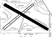
Runways
Runway Summary
| Runways: | 12/30 |
| Longest Runway: | 12/30 is 2040 ft (622 m) long |
| Runways with an Instrument Approach: |
X36 Airport Runway Details
| Runway 12/30 | 2040 ft x 120 ft (622 m x 37 m) | |
| Surface: | Turf - Fair condition - No special surface treatment | |
Runway 12 |
Runway 30 |
|
Elevation: |
14.5 | 14.7 |
Latitude: |
26-59-30.2880N | 26-59-15.6790N |
Longitude: |
082-22-37.2690W | 082-22-10.9240W |
Glide Path Angle: |
0.0 degrees | 0.0 degrees |
Traffic Pattern: |
Left | Left |
Runway Markings Type: |
Nonstandard (other than numbers only) | Nonstandard (other than numbers only) |
Runway Markings Condition: |
Fair | Fair |
Object at End: |
TREES | FENCE |
Object Height: |
12 | 4 |
Distance from End: |
335 | 0 |
Object Centerline Offset: |
40 ft. right of centerline | 107 ft. left of centerline |
Services
Airframe Repair: |
Major |
Powerplant Repair: |
Major |
Bottled Oxygen: |
None |
Bulk Oxygen: |
None |
Fuel Available: |
100LL, Jet A |
Landing Fees: |
No |
Parking: |
Tiedowns available |
Maps & Diagrams
X36 Sectional
Flight Planning
at skyvector.com
at skyvector.com