Location
Latitude: |
33-58-57.6830N (33.98269) |
Longitude: |
083-40-01.9800W (-83.667217) |
Elevation: |
934.3 feet MSL (285 m MSL) |
Magnetic Variation: |
6 W (as of April 2024 from WMM2020 model) |
Time Zone: |
UTC -5.0 (Standard Time) UTC -4.0 (Daylight Savings Time) |
From City: |
03 N.M. E of Winder, Georgia |
Found On: |
Atlanta Chart |
FAA Region: |
ASO |
Contacts
Manager: |
Publicly owned: |
| WANDA MITCHELL 841 RONALD WOOD RD WINDER, GA 30680 770-307-3013 |
BARROW COUNTY ARPT AUTH. 841 RONALD WOOD ROAD WINDER, GA 30680 770-307-3013 |
Operations
Airport Status: |
Operational |
Facility Use: |
Public |
Type: |
Airport |
Activation Date: |
07/1948 |
Control tower: |
No |
Attendance (Months/Days/Hours): |
Months/Days/Hours ALL/M-F/0900-1800 |
Boundary ARTCC: |
ZTL (Atlanta) |
Responsible ARTCC: |
ZTL (Atlanta) |
Lighting Schedule: |
SEE RMK |
Segmented Circle Indicator: |
Yes |
Traffic Pattern Altitude (MSL): |
1934 feet (589 m) |
NOTAMs Facility: |
WDR |
NOTAM-D Service: |
Yes |
International Airport of Entry: |
No |
Customs Landing Rights: |
No |
Military Landing Rights: |
Yes |
Civil/Military Joint Use: |
No |
Based Aircraft
| Single Engine: | 97 |
| Multi Engine: | 16 |
| Jet Engine: | 1 |
| GA Helicopters: | 4 |
| Military Aircraft: | 5 |
Annual Operations (as of 12/31/2022)
| Total Operations: | 50000 | |
| GA Local: | 25000 | 50.0% |
| GA Itinerant: | 20000 | 40.0% |
| Military Aircraft: | 5000 | 10.0% |
Communications
| CTAF: | 123.000 |
| Unicom: | 123.000 |
| Approach: | ATLANTA 132.475 ;0615-2200 132.475 ;0615-2200 ATLANTA ARTCC |
| Departure: | ATLANTA 132.475 ;0615-2200 132.475 ;0615-2200 ATLANTA ARTCC |
| AWOS-3: | 118.575 (770-868-0642) |
- APCH/DEP SVC PRVDD BY ATLANTA TRACON 0615-2200 ON FREQS 132.475/291.1 OTHER TIMES BY ATLANTA ARTCC ON FREQS 127.5/316.05 (ATHENS RCAG).
Fixed Based Operators (FBOs) & Fuel
(Click on a business for detail)
Please help us keep this information up to date. This is a FREE SERVICE just like everything else on Airport Guide! If you see that a business needs to be added, modified, or deleted please fill out our Update Form.
To add, modify, or delete a business click here.
Please help us keep this information up to date. This is a FREE SERVICE just like everything else on Airport Guide! If you see that a business needs to be added, modified, or deleted please fill out our Update Form.
Area Code: 770 |
| Business Name | Frequency | Phone | Fuel Grade |
|---|---|---|---|
| Peach Aviation
Update FBO info |
Unicom 123.00 | 867-1048 | 100LL, Jet A |
| Romanair, Inc.
Update FBO info |
Unicom 123.0 | 867-4001, 868-1532 | 100LL, Jet A |
| WDR Airport Services
Update FBO info |
100LL, Jet A |
Flight Service Stations
| Primary | Alternate | |
| FSS on Field: | N | |
| FSS Name (ID): | Macon(MCN) | |
| Frequency: | ||
| Toll Free Phone: | 1-800-WX-BRIEF |
Instrument Procedures / Charts
FAA Terminal Procedures valid from 0901Z 03/21/24 to 0901Z 04/18/24.
There are various types of charts available for an airport. They are listed in the Page Type column. Here is a legend for those types:
APD - Airport Diagram
DP - Departure Procedure Charts
HOT - Hot Spots
IAP - Instrument Approach Procedure Charts
MIN - Minimums
STAR - Standard Terminal Arrival Charts
| Page Type | Page Name | Volume | Action Since Last Cycle |
|---|---|---|---|
| IAP | ILS OR LOC RWY 31 | SE-4 | |
| IAP | NDB RWY 31 | SE-4 | |
| IAP | RNAV (GPS) RWY 13 | SE-4 | |
| IAP | RNAV (GPS) RWY 23 | SE-4 | |
| IAP | RNAV (GPS) RWY 31 | SE-4 | |
| MIN | ALTERNATE MINIMUMS | SE-4 | |
| MIN | TAKEOFF MINIMUMS | SE-4 |
Terminal Procedures are only available for airports in several countries with more being added all the time. If you are looking for a specific country's charts, please send an email to support(at)airportguide.com stating the country name. This will be used to prioritize the implementation.
Navigation Aids (Navaids) near WDR
| Dist (NM) | ID | Morse Code | Name | Type | Freq | True Hdg | Mag Hdg |
|---|---|---|---|---|---|---|---|
| 4.8 | BMW | _ . . . _ _ . _ _ | Barrow County | NDB | 404 | 126 | 132 |
| 8.7 | DDA | _ . . _ . . . _ | Commerce | NDB | 244 | 56 | 62 |
| 10.0 | TX | _ _ . . _ | Gwnet | NDB | 419 | 282 | 288 |
| 15.0 | JNM | . _ _ _ _ . _ _ | Monroe | NDB | 392 | 191 | 197 |
| 17.2 | AHN | . _ . . . . _ . | Athens | VOR-DME | 116.95 | 96 | 102 |
| 17.8 | FKV | . . _ . _ . _ . . . _ | Flowery Branch | NDB | 365 | 318 | 324 |
| 21.9 | VOF | . . . _ _ _ _ . . _ . | Alcovy | NDB | 370 | 195 | 201 |
| 22.4 | BJT | _ . . . . _ _ _ _ | Bulldog | NDB | 221 | 94 | 100 |
| 31.7 | AJR | . _ . _ _ _ . _ . | Habersham | NDB | 347 | 10 | 16 |
| 32.1 | PDK | . _ _ . _ . . _ . _ | Peachtree | VOR-DME | 116.60 | 258 | 264 |
| 37.9 | BR | _ . . . . _ . | Redan | NDB | 266 | 237 | 243 |
| 38.0 | VV | . . . _ . . . _ | Junne | NDB | 353 | 121 | 127 |
| 42.0 | DOB | _ . . _ _ _ _ . . . | Dobbins | TACAN | 113.00 | 264 | 270 |
| 42.5 | ATL | . _ _ . _ . . | Atlanta Muni | VOT | 111.00 | 242 | 248 |
| 42.6 | GSU | _ _ . . . . . . _ | Atlanta | DME | 116.9 | 240 | 246 |
| 43.8 | ATL | . _ _ . _ . . | Atlanta | DME | 116.9 | 241 | 247 |
| 43.8 | DJD | _ . . . _ _ _ _ . . | Chero | NDB | 415 | 291 | 297 |
| 44.3 | IIY | . . . . _ . _ _ | Washington/Wilkes County | NDB | 435 | 106 | 112 |
| 46.5 | ODF | _ _ _ _ . . . . _ . | Foothills | VOR-DME | 113.40 | 23 | 29 |
| 50.2 | FT | . . _ . _ | Flanc | NDB | 344 | 254 | 260 |
Nearby Airports with Fuel
Notices to Airmen (NOTAMS)
Remarks
| A110-1 | DEER ON AND INVOF ARPT. |
| A110-2 | CTC NG OPS 240.4. |
| A110-3 | FOR CD CTC ATLANTA APCH AT 678-346-6131, WHEN APCH CLSD CTC ATLANTA ARTCC AT 770-210-7696. |
| A110-4 | MAX CLIMB, TURN OUT EARLIER IF POSSIBLE TO MINIMIZE NOISE OVER RESIDENTIAL AREAS. |
| A57-13 | CONTROLLING OBSTRUCTION EXCEEDS A 45 DEGREE SLOPE |
| A57-31 | RWY 31 APCH RATIO 50:1 TO DSPLCD THR. |
| A58-31 | RAILROAD BETWEEN 350-500 FT LEFT FROM 0-200 FT FROM RWY END. TREES 315 FT LEFT AT RWY END. |
| A81-APT | HIRL RWY 13/31 PRESET LOW INTST; TO INCR INTST AND ACTVT MALSR RWY 31; PAPI RWYS 05, 23, 13, & 31; MIRL RWY 05/23; AND TWY LGTS - CTAF. |
| E111 | EXISTED PRIOR TO 1959. |
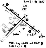
Runways
Runway Summary
| Runways: | 05/23 13/31 |
| Longest Runway: | 13/31 is 5202 ft (1586 m) long |
| Runways with an Instrument Approach: | 31 |
WDR Airport Runway Details
| Runway 05/23 | 3607 ft x 100 ft (1099 m x 30 m) | |
| Runway Length Source: | 3RD PARTY SURVEY as of 05/11/2017 | |
| Surface: | Asphalt - Good condition - No special surface treatment | |
| Runway Edge Lights: | Medium Intensity | |
Runway Weight Bearing Capacity (in thousands of pounds) |
||
| Single Wheel Landing Gear: | 20.0 | |
Runway 05 |
Runway 23 |
|
Elevation: |
934.3 | 916.3 |
Latitude: |
33-58-40.0922N | 33-59-05.0010N |
Longitude: |
083-40-23.1266W | 083-39-52.4677W |
|
Runway True Alignment: |
046 | 226 |
Glide Path Angle: |
3.0 degrees | 3.0 degrees |
Traffic Pattern: |
Left | Left |
Runway Markings Type: |
Nonprecision Instrument | Nonprecision Instrument |
Runway Markings Condition: |
Fair | Fair |
Object at End: |
TREES | TREES |
Object Height: |
77 | 38 |
Distance from End: |
1512 | 642 |
Object Centerline Offset: |
160 ft. left of centerline | 313 ft. left of centerline |
Visual Glide Slope Indicators: |
2-Light PAPI On Left Side Of Runway | 2-Light PAPI On Left Side Of Runway |
Threshold Crossing Height: |
22 | 40 |
| Runway 13/31 | 5202 ft x 100 ft (1586 m x 30 m) | |
| Runway Length Source: | 3RD PARTY SURVEY as of 05/11/2017 | |
| Surface: | Asphalt - Good condition - No special surface treatment | |
| Runway Edge Lights: | High Intensity | |
Runway Weight Bearing Capacity (in thousands of pounds) |
||
| Single Wheel Landing Gear: | 20.0 | |
Runway 13 |
Runway 31 |
|
Elevation: |
932.8 | 907.7 |
Latitude: |
33-59-17.3091N | 33-58-45.1762N |
Longitude: |
083-40-22.0715W | 083-39-33.8226W |
|
Runway True Alignment: |
129 | 309 |
ILS Type: |
ILS/DME | |
Glide Path Angle: |
3.0 degrees | 3.0 degrees |
Traffic Pattern: |
Left | Left |
Runway Markings Type: |
Nonprecision Instrument | Precision Instrument |
Runway Markings Condition: |
Fair | Fair |
Object at End: |
POLE | RR |
Object Height: |
27 | 20 |
Distance from End: |
687 | 201 |
Object Centerline Offset: |
160 ft. left of centerline | 313 ft. left of centerline |
Visual Glide Slope Indicators: |
4-Light PAPI On Left Side Of Runway | 4-Light PAPI On Left Side Of Runway |
Approach Light System: |
1,400 Foot Medium Intensity Approach Lighting System With Runway Alignment Indicator Lights | |
REIL: |
No | |
Threshold Crossing Height: |
30 | 45 |
Threshold Elevation: |
910.6 | |
Displaced Threshold: |
602 | |
Threshold Latitude: |
33-58-48.8955N | |
Threshold Longitude: |
083-39-39.4071W | |
Declared Distances |
||
Take Off Run Avbl. (TORA): |
5202 | 5202 |
Take Off Distance Avbl. (TODA): |
5202 | 5202 |
Actual Stop Dist. Avbl. (ASDA): |
5100 | 5202 |
Landing Dist. Avbl. (LDA): |
5100 | 4600 |
Services
Airframe Repair: |
Major |
Powerplant Repair: |
Major |
Bottled Oxygen: |
None |
Bulk Oxygen: |
None |
Fuel Available: |
100LL, Jet A+ |
Landing Fees: |
No |
Parking: |
Tiedowns available |
Maps & Diagrams
WDR Sectional
Flight Planning
at skyvector.com
at skyvector.com