Location
Latitude: |
45-07-59.6750N (45.133243) |
Longitude: |
115-19-18.4040W (-115.321779) |
Elevation: |
5743.0 feet MSL (1750 m MSL) |
Magnetic Variation: |
12.9 E (as of April 2024 from WMM2020 model) |
Time Zone: |
UTC -7.0 (Standard Time) UTC -6.0 (Daylight Savings Time) |
From City: |
00 N.M. NE of Big Creek, Idaho |
Found On: |
Great Falls Chart |
FAA Region: |
ANM |
Contacts
Manager: |
Publicly owned: |
| DIV ADMIN PO BOX 7129 BOISE, ID 83707-1129 208-334-8775 |
ST OF IDAHO ITD, DIV AERO PO BOX 7129 BOISE, ID 83707-1129 208-334-8775 |
Operations
Airport Status: |
Operational |
Facility Use: |
Public |
Type: |
Airport |
Activation Date: |
05/1947 |
Control tower: |
No |
Attendance (Months/Days/Hours): |
Months/Days/Hours Unattended |
Boundary ARTCC: |
ZLC (Salt Lake City) |
Responsible ARTCC: |
ZLC (Salt Lake City) |
Segmented Circle Indicator: |
Yes |
Traffic Pattern Altitude (MSL): |
6743 feet (2055 m) |
NOTAMs Facility: |
BOI |
NOTAM-D Service: |
Yes |
Military Landing Rights: |
No |
Civil/Military Joint Use: |
No |
Based Aircraft
Annual Operations (as of 07/30/2022)
| Total Operations: | 4000 | |
| Air Taxi: | 1000 | 25.0% |
| GA Itinerant: | 3000 | 75.0% |
Communications
| CTAF: | 122.900 |
Fixed Based Operators (FBOs) & Fuel
(Click on a business for detail)
Please help us keep this information up to date. This is a FREE SERVICE just like everything else on Airport Guide! If you see that a business needs to be added, modified, or deleted please fill out our Update Form.
To add, modify, or delete a business click here.
Please help us keep this information up to date. This is a FREE SERVICE just like everything else on Airport Guide! If you see that a business needs to be added, modified, or deleted please fill out our Update Form.
Area Code: 208 |
| Business Name | Frequency | Phone | Fuel Grade |
|---|
Flight Service Stations
| Primary | Alternate | |
| FSS on Field: | N | |
| FSS Name (ID): | Boise(BOI) | |
| Frequency: | ||
| Toll Free Phone: | 1-800-WX-BRIEF |
Instrument Procedures / Charts
Terminal Procedures are only available for airports in several countries with more being added all the time. If you are looking for a specific country's charts, please send an email to support(at)airportguide.com stating the country name. This will be used to prioritize the implementation.
Navigation Aids (Navaids) near U60
| Dist (NM) | ID | Morse Code | Name | Type | Freq | True Hdg | Mag Hdg |
|---|---|---|---|---|---|---|---|
| 43.5 | DNJ | _ . . _ . . _ _ _ | Donnelly | VOR-DME | 116.20 | 239 | 226 |
| 52.9 | LKT | . _ . . _ . _ _ | Salmon | VOR-DME | 113.50 | 96 | 83 |
| 73.7 | IDQ | . . _ . . _ _ . _ | Cottonwood | DME | 115.65 | 319 | 306 |
| 98.3 | ONO | _ _ _ _ . _ _ _ | Ontario | NDB | 305 | 227 | 214 |
| 99.0 | MQG | _ _ _ _ . _ _ _ . | Nez Perce | VOR-DME | 114.45 | 319 | 306 |
Nearby Airports with Fuel
Notices to Airmen (NOTAMS)
Remarks
| A110-1 | OPEN TO SKI EQPTD ACFT IN WINT; ACFT USE SIDES OF RWY DURG SKI OPS. |
| A110-2 | BE ALERT FOR SPRINKLERS ON RY. |
| A110-3 | NO WINTER MAINTENANCE. |
| A110-4 | +30' TO +60' TREES ADJ TO BOTH RY EDGES & RY ENDS. |
| A110-5 | NO TELEPHONE AVBL AT ARPT. |
| A110-6 | BIG GAME ANIMALS ON & INVOF ARPT. |
| A110-7 | FOR CD CTC SALT LAKE ARTCC AT 801-320-2568. |
| A30-01/19 | RCMD LND RWY 19 - TKOF RWY 01 - WHEN WIND CONDS ALLOW. FIRST 400 FT - 500 FT ARE ROUGH DUE TO UNEVEN GND AND TALL GRASSES. |
| A42-01 | 01/19 EDGES AND THRS MKD WITH WHITE ROCK. |
| A84 | ONE HALF SEGMENTED CIRCLE MIDFIELD. |
Runways
Runway Summary
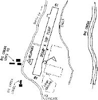
| Runways: | 01/19 |
| Longest Runway: | 01/19 is 3550 ft (1082 m) long |
| Runways with an Instrument Approach: |
U60 Airport Runway Details
| Runway 01/19 | 3550 ft x 110 ft (1082 m x 34 m) | |
| Surface: | Turf - Good condition - No special surface treatment | |
Runway 01 |
Runway 19 |
|
Glide Path Angle: |
0.0 degrees | 0.0 degrees |
Traffic Pattern: |
Left | |
Object at End: |
ROAD | TREES |
Object Height: |
15 | 50 |
Distance from End: |
50 | 0 |
Object Centerline Offset: |
65 ft. left of centerline | 100 ft. right of centerline |
Services
Airframe Repair: |
Major |
Powerplant Repair: |
Major |
Bottled Oxygen: |
Low Pressure |
Fuel Available: |
100LL |
Landing Fees: |
No |
Parking: |
Tiedowns available |
Maps & Diagrams
U60 Sectional
Flight Planning
at skyvector.com
at skyvector.com