Location
Latitude: |
46-41-22.8627N (46.689684) |
Longitude: |
092-05-40.7111W (-92.094642) |
Elevation: |
674.4 feet MSL (206 m MSL) |
Magnetic Variation: |
1.2 W (as of April 2024 from WMM2020 model) |
Time Zone: |
UTC -6.0 (Standard Time) UTC -5.0 (Daylight Savings Time) |
From City: |
03 N.M. S of Superior, Wisconsin |
Found On: |
Green Bay Chart |
FAA Region: |
AGL |
Contacts
Manager: |
Publicly owned: |
| WILLIAM AMORDE 4804 HAMMOND AVE SUPERIOR, WI 54880 715-394-0282 |
CITY OF SUPERIOR 1316 N. 14TH ST SUPERIOR, WI 54880 715-395-7200 |
Operations
Airport Status: |
Operational |
Facility Use: |
Public |
Type: |
Airport |
Activation Date: |
10/1937 |
Control tower: |
No |
Attendance (Months/Days/Hours): |
Months/Days/Hours ALL/ALL/0800-DUSK |
Boundary ARTCC: |
ZMP (Minneapolis) |
Responsible ARTCC: |
ZMP (Minneapolis) |
Lighting Schedule: |
SEE RMK |
Segmented Circle Indicator: |
No |
Traffic Pattern Altitude (MSL): |
1674 feet (510 m) |
NOTAMs Facility: |
SUW |
NOTAM-D Service: |
Yes |
International Airport of Entry: |
No |
Customs Landing Rights: |
No |
Military Landing Rights: |
Yes |
Civil/Military Joint Use: |
No |
Based Aircraft
| Single Engine: | 38 |
| Multi Engine: | 8 |
Annual Operations (as of 08/24/2022)
| Total Operations: | 19250 | |
| Air Taxi: | 700 | 3.6% |
| GA Local: | 9000 | 46.8% |
| GA Itinerant: | 9500 | 49.4% |
| Military Aircraft: | 50 | 0.3% |
Communications
| CTAF: | 122.700 |
| Unicom: | 122.700 |
| Clearance Del.: | 124.8 124.8 124.8 |
| Approach: | DULUTH |
| Departure: | DULUTH |
| AWOS-3: | 120.35 (715-394-0283) |
Fixed Based Operators (FBOs) & Fuel
(Click on a business for detail)
Please help us keep this information up to date. This is a FREE SERVICE just like everything else on Airport Guide! If you see that a business needs to be added, modified, or deleted please fill out our Update Form.
To add, modify, or delete a business click here.
Please help us keep this information up to date. This is a FREE SERVICE just like everything else on Airport Guide! If you see that a business needs to be added, modified, or deleted please fill out our Update Form.
Area Code: 715 |
| Business Name | Frequency | Phone | Fuel Grade |
|---|---|---|---|
| Paul Pederson Airmotive, Inc.
Update FBO info |
392-3526 | ||
| Twin Ports Flying Service
Update FBO info |
Unicom 122.7 | 394-6444 | 100LL, Jet A |

|
Phillips | 100LL - 2.15 USD per gallon on 10/4/01 |
24 Hour Self Serve Credit Card Pumps |
Flight Service Stations
| Primary | Alternate | |
| FSS on Field: | N | |
| FSS Name (ID): | Green Bay(GRB) | |
| Frequency: | ||
| Toll Free Phone: | 1-800-WX-BRIEF |
Instrument Procedures / Charts
FAA Terminal Procedures valid from 0901Z 03/21/24 to 0901Z 04/18/24.
There are various types of charts available for an airport. They are listed in the Page Type column. Here is a legend for those types:
APD - Airport Diagram
DP - Departure Procedure Charts
HOT - Hot Spots
IAP - Instrument Approach Procedure Charts
MIN - Minimums
STAR - Standard Terminal Arrival Charts
| Page Type | Page Name | Volume | Action Since Last Cycle |
|---|---|---|---|
| IAP | RNAV (GPS) RWY 04 | EC-3 | |
| IAP | RNAV (GPS) RWY 14 | EC-3 | |
| IAP | RNAV (GPS) RWY 22 | EC-3 | |
| IAP | RNAV (GPS) RWY 32 | EC-3 | |
| MIN | ALTERNATE MINIMUMS | EC-3 | |
| MIN | TAKEOFF MINIMUMS | EC-3 |
Terminal Procedures are only available for airports in several countries with more being added all the time. If you are looking for a specific country's charts, please send an email to support(at)airportguide.com stating the country name. This will be used to prioritize the implementation.
Navigation Aids (Navaids) near SUW
| Dist (NM) | ID | Morse Code | Name | Type | Freq | True Hdg | Mag Hdg |
|---|---|---|---|---|---|---|---|
| 8.1 | DLH | _ . . . _ . . . . . . | Duluth | VORTAC | 112.60 | 326 | 327 |
| 10.0 | LKI | . _ . . _ . _ . . | Lakeside | TACAN | 135.40 | 337 | 338 |
| 14.2 | DL | _ . . . _ . . | Pykla | NDB | 379 | 311 | 312 |
| 16.8 | COQ | _ . _ . _ _ _ _ _ . _ | Cloquet | NDB | 335 | 271 | 272 |
| 33.6 | MZH | _ _ _ _ . . . . . . | Moose Lake | NDB | 362 | 241 | 242 |
| 43.7 | BFW | _ . . . . . _ . . _ _ | Silver Bay | NDB | 350 | 39 | 41 |
| 44.4 | HIB | . . . . . . _ . . . | Hibbing | VOR-DME | 110.80 | 326 | 327 |
| 47.0 | EVM | . . . . _ _ _ | Eveleth | VOR-DME | 108.20 | 339 | 340 |
| 48.4 | HYR | . . . . _ . _ _ . _ . | Hayward | DME | 113.4 | 146 | 147 |
| 49.2 | ASX | . _ . . . _ . . _ | Ashland | VOR-DME | 110.20 | 99 | 101 |
| 53.3 | BXR | _ . . . _ . . _ . _ . | Big Doctor | NDB | 203 | 192 | 193 |
| 53.4 | RZN | . _ . _ _ . . _ . | Siren | DME | 109.4 | 192 | 193 |
| 62.7 | GP | _ _ . . _ _ . | Galex | NDB | 272 | 295 | 296 |
| 63.8 | GPZ | _ _ . . _ _ . _ _ . . | Grand Rapids | VOR-DME | 111.40 | 296 | 297 |
| 65.7 | AIT | . _ . . _ | Aitkin | NDB | 397 | 263 | 264 |
| 68.3 | JMR | . _ _ _ _ _ . _ . | Mora | NDB | 327 | 225 | 226 |
| 68.8 | ELO | . . _ . . _ _ _ | Ely | DME | 108.15 | 8 | 9 |
| 69.5 | ROS | . _ . _ _ _ . . . | Rush City | NDB | 282 | 211 | 212 |
| 77.6 | RPD | . _ . . _ _ . _ . . | Rice Lake | VOR-DME | 110.00 | 170 | 171 |
| 80.7 | BR | _ . . . . _ . | Larew | NDB | 251 | 260 | 260 |
Nearby Airports with Fuel
Notices to Airmen (NOTAMS)
Remarks
| A110-5 | DEER ON & VICINITY OF ARPT. |
| A110-6 | FOR CD CTC DULUTH APCH AT 218-740-5950. |
| A70-FUEL-10 | 0LL 24 HR FUEL AVBL WITH CREDIT CARD. |
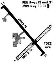
| A81-APT | ACTVT REIL RWY 04, 14, & 32 - CTAF. MIRL RWY 04/22 & RWY 14/32 PRESET TO LOW SS-SR, TO INCR INTST & ACTVT - CTAF. |
Runways
Runway Summary
| Runways: | 04/22 14/32 |
| Longest Runway: | 04/22 is 5100 ft (1554 m) long |
| Runways with an Instrument Approach: |
SUW Airport Runway Details
| Runway 04/22 | 5100 ft x 75 ft (1554 m x 23 m) | |
| Runway Length Source: | 3RD PARTY SURVEY as of 06/01/2009 | |
| Surface: | Asphalt - Fair condition - No special surface treatment | |
| Runway Edge Lights: | Medium Intensity | |
Runway 04 |
Runway 22 |
|
Elevation: |
670.3 | 659.6 |
Latitude: |
46-41-20.9620N | 46-42-01.2366N |
Longitude: |
092-06-01.0734W | 092-05-17.1941W |
|
Runway True Alignment: |
037 | 217 |
Glide Path Angle: |
3.0 degrees | 0.0 degrees |
Runway Markings Type: |
Nonprecision Instrument | Nonprecision Instrument |
Runway Markings Condition: |
Good | Good |
Visual Glide Slope Indicators: |
4-Light PAPI On Left Side Of Runway | |
REIL: |
Yes | No |
Touchdown Lights: |
No | No |
Centerline Lights: |
No | No |
Threshold Crossing Height: |
28 |
| Runway 14/32 | 4001 ft x 75 ft (1220 m x 23 m) | |
| Runway Length Source: | 3RD PARTY SURVEY as of 06/01/2009 | |
| Surface: | Asphalt - Fair condition - No special surface treatment | |
| Runway Edge Lights: | Medium Intensity | |
Runway 14 |
Runway 32 |
|
Elevation: |
672.1 | 672.7 |
Latitude: |
46-41-14.7678N | 46-40-44.4542N |
Longitude: |
092-06-01.1096W | 092-05-24.3350W |
|
Runway True Alignment: |
140 | 320 |
Glide Path Angle: |
0.0 degrees | 4.0 degrees |
Traffic Pattern: |
Left | Left |
Runway Markings Type: |
Nonprecision Instrument | Nonprecision Instrument |
Runway Markings Condition: |
Good | Good |
Visual Glide Slope Indicators: |
4-Light PAPI On Left Side Of Runway | |
REIL: |
Yes | Yes |
Touchdown Lights: |
No | No |
Centerline Lights: |
No | No |
Threshold Crossing Height: |
41 |
Services
Airframe Repair: |
None |
Powerplant Repair: |
None |
Bottled Oxygen: |
None |
Bulk Oxygen: |
None |
Fuel Available: |
100LL, Jet A |
Landing Fees: |
No |
Parking: |
Hangars and tiedowns available |
Maps & Diagrams
SUW Sectional
Flight Planning
at skyvector.com
at skyvector.com