Location
Latitude: |
44-46-09.1000N (44.769194) |
Longitude: |
106-58-49.0000W (-106.980278) |
Elevation: |
4021.1 feet MSL (1226 m MSL) |
Magnetic Variation: |
9.3 E (as of April 2024 from WMM2020 model) |
Time Zone: |
UTC -7.0 (Standard Time) UTC -6.0 (Daylight Savings Time) |
From City: |
02 N.M. SW of Sheridan, Wyoming |
Found On: |
Billings Chart |
FAA Region: |
ANM |
Contacts
Manager: |
Publicly owned: |
| E. ROBERT GILL 908 WEST BRUNDAGE LANE SHERIDAN, WY 82801-5827 307-674-4222 |
SHERIDAN COUNTY 908 W BRUNDAGE LANE SHERIDAN, WY 82801-5896 307-674-4222 |
Operations
Airport Status: |
Operational |
Facility Use: |
Public |
Type: |
Airport |
Activation Date: |
10/1937 |
Control tower: |
No |
Attendance (Months/Days/Hours): |
Months/Days/Hours ALL/ALL/DALGT |
Boundary ARTCC: |
ZLC (Salt Lake City) |
Responsible ARTCC: |
ZLC (Salt Lake City) |
Lighting Schedule: |
SEE RMK |
Segmented Circle Indicator: |
Yes |
Traffic Pattern Altitude (MSL): |
5021 feet (1530 m) |
NOTAMs Facility: |
SHR |
NOTAM-D Service: |
Yes |
International Airport of Entry: |
No |
Customs Landing Rights: |
No |
Military Landing Rights: |
Yes |
Civil/Military Joint Use: |
No |
Aircraft Rescue and Firefighting: |
Class I ARFF Index: A Air Carrier Service: Scheduled Certification Date: 05/1973 |
Based Aircraft
| Single Engine: | 54 |
| Multi Engine: | 18 |
| Jet Engine: | 2 |
| GA Helicopters: | 3 |
Annual Operations (as of 12/31/2018)
| Total Operations: | 28656 | |
| Air Taxi: | 1508 | 5.3% |
| GA Local: | 11381 | 39.7% |
| GA Itinerant: | 15717 | 54.8% |
| Military Aircraft: | 50 | 0.2% |
Communications
| CTAF: | 123.000 |
| Unicom: | 123.000 |
| ASOS: | 135.175 (307-672-5349) |
- APCH/DEP CTL SVC PRVDD BY SALT LAKE ARTCC (ZLC) ON FREQS 127.75/351.9 (SHERIDAN RCAG).
Fixed Based Operators (FBOs) & Fuel
(Click on a business for detail)
Please help us keep this information up to date. This is a FREE SERVICE just like everything else on Airport Guide! If you see that a business needs to be added, modified, or deleted please fill out our Update Form.
To add, modify, or delete a business click here.
Please help us keep this information up to date. This is a FREE SERVICE just like everything else on Airport Guide! If you see that a business needs to be added, modified, or deleted please fill out our Update Form.
Area Code: 307 |
| Business Name | Frequency | Phone | Fuel Grade |
|---|---|---|---|
| Avcon Electronics
Update FBO info |
672-5202 | ||
| Bighorn Airways, Inc.
Update FBO info |
Unicom 123.0 | 672-3421 | 100, Jet A |
Flight Service Stations
| Primary | Alternate | |
| FSS on Field: | ||
| FSS Name (ID): | Casper(CPR) | |
| Frequency: | ||
| Toll Free Phone: | 1-800-WX-BRIEF |
Instrument Procedures / Charts
FAA Terminal Procedures valid from 0901Z 03/21/24 to 0901Z 04/18/24.
There are various types of charts available for an airport. They are listed in the Page Type column. Here is a legend for those types:
APD - Airport Diagram
DP - Departure Procedure Charts
HOT - Hot Spots
IAP - Instrument Approach Procedure Charts
MIN - Minimums
STAR - Standard Terminal Arrival Charts
| Page Type | Page Name | Volume | Action Since Last Cycle |
|---|---|---|---|
| APD | AIRPORT DIAGRAM | NW-1 | |
| IAP | ILS OR LOC/DME RWY 33 | NW-1 | |
| IAP | RNAV (GPS) RWY 15 | NW-1 | |
| IAP | RNAV (GPS) RWY 33 | NW-1 | |
| IAP | VOR RWY 15 | NW-1 | |
| MIN | ALTERNATE MINIMUMS | NW-1 | |
| MIN | TAKEOFF MINIMUMS | NW-1 |
Terminal Procedures are only available for airports in several countries with more being added all the time. If you are looking for a specific country's charts, please send an email to support(at)airportguide.com stating the country name. This will be used to prioritize the implementation.
Navigation Aids (Navaids) near SHR
| Dist (NM) | ID | Morse Code | Name | Type | Freq | True Hdg | Mag Hdg |
|---|---|---|---|---|---|---|---|
| 5.6 | SHR | . . . . . . . . _ . | Sheridan | VOR-DME | 113.55 | 321 | 312 |
| 49.5 | GEY | _ _ . . _ . _ _ | Greybull | NDB | 275 | 252 | 242 |
| 51.7 | CZI | _ . _ . _ _ . . . . | Crazy Woman | VOR-DME | 117.30 | 152 | 143 |
| 62.8 | HCY | . . . . _ . _ . _ . _ _ | Cowley | NDB | 257 | 278 | 268 |
| 63.8 | RLY | . _ . . _ . . _ . _ _ | Worland | VOR-DME | 114.80 | 221 | 212 |
| 66.4 | GCC | _ _ . _ . _ . _ . _ . | Gillette | VOR-DME | 114.60 | 111 | 102 |
| 69.2 | GC | _ _ . _ . _ . | Deryk | NDB | 380 | 115 | 106 |
| 77.1 | POY | . _ _ . _ _ _ _ . _ _ | Powell | NDB | 344 | 274 | 264 |
| 77.6 | BDX | _ . . . _ . . _ . . _ | Broadus | NDB | 335 | 58 | 49 |
| 85.1 | COD | _ . _ . _ _ _ _ . . | Cody | VOR-DME | 111.80 | 264 | 254 |
| 92.0 | FOR | . . _ . _ _ _ . _ . | Forsyth | NDB | 236 | 12 | 3 |
| 93.3 | BIL | _ . . . . . . _ . . | Billings | VORTAC | 114.50 | 312 | 302 |
| 96.8 | BOY | _ . . . _ _ _ _ . _ _ | Boysen Reservoir | VOR-DME | 117.80 | 216 | 206 |
| 97.2 | BI | _ . . . . . | Saige | NDB | 251 | 312 | 302 |
Nearby Airports with Fuel
| Dist (NM) | Name (Airport IDs) | True Hdg | Mag Hdg | Fuel Grade |
|---|---|---|---|---|
| 25.8 | Johnson County Airport (BYG KBYG BYG) |
154 | 145 | 100LL, Jet A |
| 49.4 | South Big Horn County Airport (GEY KGEY GEY) |
252 | 242 | 100LL, Jet A |
| 62.9 | North Big Horn County Airport (U68) |
278 | 268 | 100LL |
| 63.8 | Worland Municipal Airport (WRL KWRL WRL) |
221 | 211 | 100LL, Jet A |
| 66.6 | Northeast Wyoming Regional Airport (GCC KGCC GCC) |
111 | 103 | 100LL, Jet A |
| 77.4 | Powell Municipal Airport (POY KPOY POY) |
274 | 264 | 100LL, Jet A |
| 88.5 | Yellowstone Regional Airport (COD KCOD COD) |
261 | 251 | 100, 100LL, Jet A, Jet A+ |
| 90.8 | Billings Logan International Airport (BIL KBIL BIL) |
313 | 303 | 100LL, Jet A |
| 93.9 | Laurel Municipal Airport (6S8) |
307 | 297 | 100LL, Jet A |
| 99.8 | Red Lodge Airport (KRED RED) |
285 | 275 | 100LL |
Notices to Airmen (NOTAMS)
Remarks
| A110-4 | FW ACFT RSTRD TO RWYS & TWYS ONLY. |
| A110-6 | COLD TEMPERATURE AIRPORT. ALTITUDE CORRECTION REQUIRED AT OR BELOW -19C. |
| A110-7 | FOR CD IF UNA TO CTC ON FSS FREQ, CTC SALT LAKE ARTCC AT 801-320-2568. |
| A17 | CONDS NOT MONITORED AT NGT AFT THE LAST ACR ARR TIL 0500L. SEE NOTAMS FOR THE MOST UP-TO-DATE CONDS AND UPDTS. |
| A26 | PPR UNSKED ACFT OPS WITH MORE THAN 30 PAX SEATS CTC ARFF STN 307-673-1875. |
| A81-APT | ACTVT MALSR RWY 33; REIL RWY 06, 24, & 15; PAPI RWY 06, 24, 15 & 33; HIRL RWY 15/33; MIRL RWY 06/24 - CTAF. |
| E147 | TPA: 800 FT AGL SNGL ENG, 1500 FT AGL TURBOPROP/JET. |
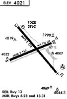
Runways
Runway Summary
| Runways: | 06/24 15/33 |
| Longest Runway: | 15/33 is 8301 ft (2530 m) long |
| Runways with an Instrument Approach: | 33 |
SHR Airport Runway Details
| Runway 06/24 | 5039 ft x 75 ft (1536 m x 23 m) | |
| Runway Length Source: | 3RD PARTY SURVEY as of 10/18/2013 | |
| Surface: | Asphalt - Good condition - Saw-cut or plastic grooved | |
| Runway Pavement Class: | 11 /F/B/X/U | |
| Runway Edge Lights: | Medium Intensity | |
Runway Weight Bearing Capacity (in thousands of pounds) |
||
| Single Wheel Landing Gear: | 36.0 | |
| Dual Wheel Landing Gear: | 50.0 | |
Runway 06 |
Runway 24 |
|
Elevation: |
4021.1 | 3939.1 |
Latitude: |
44-46-15.1678N | 44-46-33.8008N |
Longitude: |
106-59-15.1526W | 106-58-10.4086W |
|
Runway True Alignment: |
068 | 248 |
Glide Path Angle: |
4.0 degrees | 3.0 degrees |
Traffic Pattern: |
Left | Left |
Runway Markings Type: |
Nonprecision Instrument | Nonprecision Instrument |
Runway Markings Condition: |
Good | Good |
Object at End: |
TREES | |
Object Height: |
40 | |
Distance from End: |
750 | |
Object Centerline Offset: |
200 ft. right of centerline | |
Visual Glide Slope Indicators: |
4-Light PAPI On Left Side Of Runway | 4-Light PAPI On Left Side Of Runway |
REIL: |
Yes | Yes |
Threshold Crossing Height: |
57 | 39 |
Declared Distances |
||
Take Off Run Avbl. (TORA): |
5039 | 5039 |
Take Off Distance Avbl. (TODA): |
5039 | 5039 |
Actual Stop Dist. Avbl. (ASDA): |
5039 | 5039 |
Landing Dist. Avbl. (LDA): |
5039 | 5039 |
| Runway 15/33 | 8301 ft x 100 ft (2530 m x 30 m) | |
| Runway Length Source: | 3RD PARTY SURVEY as of 10/18/2013 | |
| Surface: | Asphalt - Good condition - Porous friction course | |
| Runway Pavement Class: | 22 /F/B/X/U | |
| Runway Edge Lights: | High Intensity | |
Runway Weight Bearing Capacity (in thousands of pounds) |
||
| Single Wheel Landing Gear: | 60.0 | |
| Dual Wheel Landing Gear: | 75.0 | |
Runway 15 |
Runway 33 |
|
Elevation: |
4014.2 | 3975.4 |
Latitude: |
44-46-37.3147N | 44-45-22.2735N |
Longitude: |
106-59-15.9177W | 106-58-29.7203W |
|
Runway True Alignment: |
156 | 336 |
ILS Type: |
ILS/DME | |
Glide Path Angle: |
3.0 degrees | 3.0 degrees |
Runway Markings Type: |
Nonprecision Instrument | Precision Instrument |
Runway Markings Condition: |
Good | Good |
Object Centerline Offset: |
200 ft. right of centerline | |
Visual Glide Slope Indicators: |
4-Light PAPI On Left Side Of Runway | 4-Light PAPI On Left Side Of Runway |
Approach Light System: |
1,400 Foot Medium Intensity Approach Lighting System With Runway Alignment Indicator Lights | |
REIL: |
Yes | |
Threshold Crossing Height: |
50 | 54 |
Declared Distances |
||
Take Off Run Avbl. (TORA): |
8301 | 8301 |
Take Off Distance Avbl. (TODA): |
8301 | 8301 |
Actual Stop Dist. Avbl. (ASDA): |
8301 | 8301 |
Landing Dist. Avbl. (LDA): |
8301 | 8301 |
Services
Airframe Repair: |
None |
Powerplant Repair: |
None |
Bottled Oxygen: |
None |
Bulk Oxygen: |
None |
Fuel Available: |
100LL |
Landing Fees: |
No |
Parking: |
Tiedowns available |
Maps & Diagrams
SHR Sectional
Flight Planning
at skyvector.com
at skyvector.com