Location
Latitude: |
59-27-36.7200N (59.4602) |
Longitude: |
135-19-00.6950W (-135.31686) |
Elevation: |
44.0 feet MSL (13 m MSL) |
Magnetic Variation: |
18.4 E (as of April 2024 from WMM2020 model) |
Time Zone: |
UTC -9.0 (Standard Time) UTC -8.0 (Daylight Savings Time) |
From City: |
00 N.M. NW of Skagway, Alaska |
Found On: |
Juneau Chart |
FAA Region: |
AAL |
Contacts
Manager: |
Publicly owned: |
| SHAUN MCKNIGHT BOX 356 SKAGWAY, AK 99840 907-983-2323 |
ALASKA DOT&PF SOUTHCOAST REGION P.O. BOX 112506 JUNEAU, AK 99811-2506 (907) 983-2323 |
Operations
Airport Status: |
Operational |
Facility Use: |
Public |
Type: |
Airport |
Activation Date: |
02/1947 |
Control tower: |
No |
Attendance (Months/Days/Hours): |
Months/Days/Hours Unattended |
Boundary ARTCC: |
ZAN (Anchorage) |
Responsible ARTCC: |
ZAN (Anchorage) |
Lighting Schedule: |
SEE RMK |
Segmented Circle Indicator: |
No |
Traffic Pattern Altitude (MSL): |
1044 feet (318 m) |
NOTAMs Facility: |
SGY |
NOTAM-D Service: |
Yes |
International Airport of Entry: |
No |
Customs Landing Rights: |
Yes |
Military Landing Rights: |
Yes |
Civil/Military Joint Use: |
No |
Based Aircraft
| Single Engine: | 12 |
| GA Helicopters: | 7 |
Annual Operations (as of 12/31/2022)
| Total Operations: | 4300 | |
| Air Taxi: | 3800 | 88.4% |
| GA Local: | 500 | 11.6% |
Communications
| CTAF: | 122.900 |
| ASOS: | 135.8 (907-983-3194) |
Fixed Based Operators (FBOs) & Fuel
(Click on a business for detail)
Please help us keep this information up to date. This is a FREE SERVICE just like everything else on Airport Guide! If you see that a business needs to be added, modified, or deleted please fill out our Update Form.
To add, modify, or delete a business click here.
Please help us keep this information up to date. This is a FREE SERVICE just like everything else on Airport Guide! If you see that a business needs to be added, modified, or deleted please fill out our Update Form.
Area Code: 907 |
| Business Name | Frequency | Phone | Fuel Grade |
|---|---|---|---|
| Fossil Fuels
Update FBO info |
983-2314 | 100LL |
Flight Service Stations
| Primary | Alternate | |
| FSS on Field: | N | |
| FSS Name (ID): | Juneau(JNU) | |
| Frequency: | ||
| Toll Free Phone: | 1-866-297-2236 |
Instrument Procedures / Charts
Terminal Procedures are only available for airports in several countries with more being added all the time. If you are looking for a specific country's charts, please send an email to support(at)airportguide.com stating the country name. This will be used to prioritize the implementation.
Navigation Aids (Navaids) near SGY
| Dist (NM) | ID | Morse Code | Name | Type | Freq | True Hdg | Mag Hdg |
|---|---|---|---|---|---|---|---|
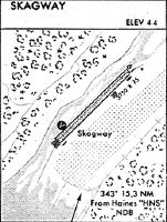
| 15.3 | HNS | . . . . _ . . . . | Haines | NDB | 245 | 193 | 175 |
| 60.3 | PJ | . _ _ . . _ _ _ | Robinson | NDB | 329 | 12 | 354 |
| 63.5 | GAV | _ _ . . _ . . . _ | Gustavus | NDB | 219 | 191 | 173 |
| 66.5 | JDL | . _ _ _ _ . . . _ . . | Lynns | FAN MARKER | 173 | 155 | |
| 68.8 | CGL | _ . _ . _ _ . . _ . . | Coghlan Island | NDB | 212 | 163 | 145 |
| 69.4 | JNU | . _ _ _ _ . . . _ | Juneau | VOT | 111.00 | 161 | 143 |
| 69.7 | YXY | _ . _ _ _ . . _ _ . _ _ | Whitehorse | VOR-DME | 116.60 | 4 | 346 |
| 71.1 | ZXY | Klondike | NDB | 353 | 7 | 349 | |
| 77.0 | SSR | . . . . . . . _ . | Sisters Island | VORTAC | 114.00 | 178 | 160 |
| 77.4 | EEF | . . . . _ . | Elephant | NDB | 391 | 178 | 160 |
| 79.0 | XY | Whitehorse | NDB | 302 | 4 | 346 | |
| 89.5 | JB | Laberge | NDB | 236 | 3 | 345 |
Nearby Airports with Fuel
| Dist (NM) | Name (Airport IDs) | True Hdg | Mag Hdg | Fuel Grade |
|---|---|---|---|---|
| 14.4 | Haines Airport (HNS PAHN HNS) |
206 | 188 | 100LL, Jet A |
| 63.3 | Gustavus Airport (GST PAGS GST) |
191 | 173 | Jet A |
| 70.2 | Juneau International Airport (JNU PAJN JNU) |
160 | 142 | 100LL, Jet A-1+ |
| 75.3 | Whitehorse/Erik Nielsen International Airport (YXY CYXY CYXY) |
5 | 346 | 100LL, Jet A |
Notices to Airmen (NOTAMS)
Remarks
| A110-10 | ACFT OVR 12500 LB GWT NA EXC PPR IN WRITING - AMGR. |
| A110-14 | PAJA TO RWY, TWY & PRKG APRON NA. |
| A110-16 | RCMD DALGT OPS ONLY. |
| A110-2 | ARPT COND UNMNT; MAINT IREG; RCMND VISUAL INSP PRIOR TO USE. |
| A110-20 | ACR OPS OVER 30 PAX SEATS NA. |
| A110-22 | WX CAMERA AVBL ON INTERNET AT HTTPS://WEATHERCAMS.FAA.GOV |
| A110-3 | BIRDS & BEARS INVOF ARPT. |
| A110-6 | JUNEAU FSS FONE IN FUEL AREA. |
| A110-9 | LIGHT ACFT & HEL TFC JUNE 1 - SEP 15 - INFO AMGR. |
| A30A-02 | ALERT: SEE GENOT FOR RWY 02 DEP INFO & ENR CTAF FREQS. DEP REQ HIGH PER CLIMB DUE TO TRRN. DEP MAY DOGLEG EAST BFR TURN CROSSWIND TO INCR ALT; MNTN RWY HDG AT LEAST 1/2 MI BFR DOGLEG TO AVOID SCHOOL & PLAYGROUND. |
| A30A-20 | APCH IN NRW CANYON; TURB & HIGH OBSTNS. SCHOOL & PLAYGROUND INVOF APCH END. |
| A48-02 | NSTD OMNIDIRECTIONAL. |
| A48-20 | NSTD OMNIDIRECTIONAL. |
| A70-FUEL-10 | 0LL FUEL MON-FRI 0800-1700 - 907-983-2259; AFT HR - 907-612-0049. |
| A81-APT | ACTVT REIL RWY 02 & 20; MIRL RWY 02/20 - CTAF. |
Runways
Runway Summary
| Runways: | 02/20 |
| Longest Runway: | 02/20 is 3550 ft (1082 m) long |
| Runways with an Instrument Approach: |
SGY Airport Runway Details
| Runway 02/20 | 3550 ft x 75 ft (1082 m x 23 m) | |
| Surface: | Asphalt - Good condition - No special surface treatment | |
| Runway Edge Lights: | Medium Intensity | |
Runway 02 |
Runway 20 |
|
Elevation: |
30.0 | 59.0 |
Latitude: |
59-27-24.2300N | 59-27-49.2500N |
Longitude: |
135-19-24.6700W | 135-18-36.5800W |
Glide Path Angle: |
0.0 degrees | 0.0 degrees |
Traffic Pattern: |
Right | |
Runway Markings Type: |
Basic | Basic |
Runway Markings Condition: |
Fair | Fair |
Object at End: |
TREES | TREES |
Object Height: |
96 | 80 |
Distance from End: |
620 | 551 |
Object Centerline Offset: |
220 ft. left of centerline | 200 ft. right of centerline |
REIL: |
Yes | Yes |
Services
Airframe Repair: |
Minor |
Powerplant Repair: |
Minor |
Fuel Available: |
100LL, Jet A |
Maps & Diagrams
SGY Sectional
Flight Planning
at skyvector.com
at skyvector.com