Location
Latitude: |
48-32-26.5000N (48.540694) |
Longitude: |
111-52-16.5000W (-111.87125) |
Elevation: |
3442.9 feet MSL (1049 m MSL) |
Magnetic Variation: |
12.2 E (as of April 2024 from WMM2020 model) |
Time Zone: |
UTC -7.0 (Standard Time) UTC -6.0 (Daylight Savings Time) |
From City: |
02 N.M. N of Shelby, Montana |
Found On: |
Great Falls Chart |
FAA Region: |
ANM |
Contacts
Manager: |
Publicly owned: |
| JERRY LARSON JR PO BOX 210 SHELBY, MT 59474 (406) 450-2463 |
TOOLE COUNTY 226 1ST ST. SOUTH SHELBY, MT 59474-1920 406-424-8310 |
Operations
Airport Status: |
Operational |
Facility Use: |
Public |
Type: |
Airport |
Activation Date: |
10/1948 |
Control tower: |
No |
Attendance (Months/Days/Hours): |
Months/Days/Hours ALL/MON-FRI/0800-1800 |
Boundary ARTCC: |
ZLC (Salt Lake City) |
Responsible ARTCC: |
ZLC (Salt Lake City) |
Lighting Schedule: |
SEE RMK |
Segmented Circle Indicator: |
Yes |
Traffic Pattern Altitude (MSL): |
4443 feet (1354 m) |
NOTAMs Facility: |
GTF |
NOTAM-D Service: |
Yes |
International Airport of Entry: |
No |
Customs Landing Rights: |
No |
Military Landing Rights: |
Yes |
Civil/Military Joint Use: |
No |
Based Aircraft
| Single Engine: | 17 |
| Multi Engine: | 3 |
| Jet Engine: | 2 |
| GA Helicopters: | 1 |
Annual Operations (as of 07/27/2023)
| Total Operations: | 8400 | |
| Air Taxi: | 100 | 1.2% |
| GA Local: | 7050 | 83.9% |
| GA Itinerant: | 1000 | 11.9% |
| Military Aircraft: | 250 | 3.0% |
Communications
| CTAF: | 122.800 |
| Unicom: | 122.800 |
| AWOS-3PT: | 128.325 (406-434-2542) |
- APCH/DEP CTL SVC PRVDD BY SALT LAKE CITY ARTCC ( ZLC) ON FREQS 133.4/285.4 (GREAT FALLS RCAG).
- COMMUNICATIONS PRVDD BY GREAT FALLS RADIO ON FREQ 122.2 (CUT BANK RCO).
Fixed Based Operators (FBOs) & Fuel
(Click on a business for detail)
Please help us keep this information up to date. This is a FREE SERVICE just like everything else on Airport Guide! If you see that a business needs to be added, modified, or deleted please fill out our Update Form.
To add, modify, or delete a business click here.
Please help us keep this information up to date. This is a FREE SERVICE just like everything else on Airport Guide! If you see that a business needs to be added, modified, or deleted please fill out our Update Form.
Area Code: 406 |
| Business Name | Frequency | Phone | Fuel Grade |
|---|---|---|---|
| Larson Flying Service
Update FBO info |
Unicom 122.8 | 434-5501 | 80, 100LL, Jet A |
| North Aero Maintenance
Update FBO info |
434-5481 |
Flight Service Stations
| Primary | Alternate | |
| FSS on Field: | N | |
| FSS Name (ID): | Great Falls(GTF) | |
| Frequency: | ||
| Toll Free Phone: | 1-800-WX-BRIEF |
Instrument Procedures / Charts
FAA Terminal Procedures valid from 0901Z 03/21/24 to 0901Z 04/18/24.
There are various types of charts available for an airport. They are listed in the Page Type column. Here is a legend for those types:
APD - Airport Diagram
DP - Departure Procedure Charts
HOT - Hot Spots
IAP - Instrument Approach Procedure Charts
MIN - Minimums
STAR - Standard Terminal Arrival Charts
| Page Type | Page Name | Volume | Action Since Last Cycle |
|---|---|---|---|
| IAP | RNAV (GPS) RWY 05 | NW-1 | |
| IAP | RNAV (GPS) RWY 23 | NW-1 | |
| MIN | ALTERNATE MINIMUMS | NW-1 | |
| MIN | TAKEOFF MINIMUMS | NW-1 |
Terminal Procedures are only available for airports in several countries with more being added all the time. If you are looking for a specific country's charts, please send an email to support(at)airportguide.com stating the country name. This will be used to prioritize the implementation.
Navigation Aids (Navaids) near SBX
| Dist (NM) | ID | Morse Code | Name | Type | Freq | True Hdg | Mag Hdg |
|---|---|---|---|---|---|---|---|
| 0.4 | SBX | . . . _ . . . _ . . _ | Shelby | NDB | 347 | 87 | 75 |
| 18.8 | CTB | _ . _ . _ _ . . . | Cut Bank | VOR-DME | 113.35 | 274 | 262 |
| 21.4 | CRD | _ . _ . . _ . _ . . | Conrad | NDB | 293 | 184 | 172 |
| 35.4 | LTY | . _ . . _ _ . _ _ | Chester | NDB | 323 | 92 | 80 |
| 44.7 | CII | _ . _ . . . . . | Choteau | NDB | 269 | 195 | 183 |
| 68.0 | GTF | _ _ . _ . . _ . | Great Falls | VORTAC | 115.10 | 164 | 152 |
| 72.7 | YQL | _ . _ _ _ _ . _ . _ . . | Lethbridge | VOR-DME | 115.70 | 334 | 322 |
| 73.3 | ITU | . . _ . . _ | Truly | NDB | 371 | 163 | 151 |
| 75.5 | QL | Lethbridge | NDB | 248 | 328 | 315 | |
| 78.0 | 3Z | Taber | NDB-DME | 388 | 351 | 339 | |
| 83.5 | HVR | . . . . . . . _ . _ . | Havre | VOR-DME | 114.65 | 89 | 77 |
| 93.9 | FCA | . . _ . _ . _ . . _ | Kalispell | VOR-DME | 113.20 | 258 | 245 |
| 97.8 | XH | Medicine Hat | NDB | 332 | 25 | 13 |
Nearby Airports with Fuel
| Dist (NM) | Name (Airport IDs) | True Hdg | Mag Hdg | Fuel Grade |
|---|---|---|---|---|
| 20.5 | Cut Bank International Airport (CTB KCTB CTB) |
281 | 269 | 100LL, Jet A, Jet A+ |
| 22.7 | Conrad Airport (S01) |
190 | 178 | 100LL |
| 35.0 | Liberty County Airport (KLTY LTY) |
92 | 80 | 100LL |
| 44.4 | Choteau Airport (KCII CII) |
195 | 183 | 100LL, Jet A |
| 64.7 | Fort Benton Airport (79S) |
129 | 118 | 100LL |
| 66.6 | Great Falls International Airport (GTF KGTF GTF) |
162 | 150 | 100LL, Jet A |
| 73.6 | Big Sandy Airport (3U8) |
107 | 96 | 100LL |
| 83.8 | Havre City-County Airport (HVR KHVR HVR) |
89 | 78 | 100LL, Jet A+ |
| 95.9 | Glacier Park International Airport (FCA KGPI GPI) |
262 | 249 | 100LL, Jet A |
| 99.4 | Kalispell City Airport (S27) |
258 | 245 | 100LL, Jet A |
Notices to Airmen (NOTAMS)
Remarks
| A110-1 | DEER ON & INVOF ARPT. |
| A110-2 | TWY EDGES MKD WITH REFLECTORS. |
| A110-4 | FOR CD CTC SALT LAKE ARTCC AT 801-320-2568. |
| A70-FUEL-10 | 0LL FOR FUEL AFTER HRS CALL 406-450-2461 OR 406-450-2463. SELF SVC CREDIT CARD FOR 100LL & JET A+. FUEL TRUCK AVBL FOR JET A+. |
| A81-APT | ACTVT PAPI RWY 05 & 23; MIRL RWY 05/23 & 11/29-CTAF. |
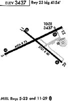
Runways
Runway Summary
| Runways: | 05/23 11/29 |
| Longest Runway: | 05/23 is 5005 ft (1526 m) long |
| Runways with an Instrument Approach: |
SBX Airport Runway Details
| Runway 05/23 | 5005 ft x 75 ft (1526 m x 23 m) | |
| Runway Length Source: | 3RD PARTY SURVEY as of 08/27/2009 | |
| Surface: | Asphalt - Excellent condition - No special surface treatment | |
| Runway Pavement Class: | 6 /F/D/Y/T | |
| Runway Edge Lights: | Medium Intensity | |
Runway Weight Bearing Capacity (in thousands of pounds) |
||
| Single Wheel Landing Gear: | 15.0 | |
Runway 05 |
Runway 23 |
|
Elevation: |
3418.1 | 3442.8 |
Latitude: |
48-32-18.0685N | 48-32-38.9581N |
Longitude: |
111-52-53.1372W | 111-51-45.7658W |
|
Runway True Alignment: |
065 | 245 |
Glide Path Angle: |
3.0 degrees | 3.0 degrees |
Traffic Pattern: |
Left | Left |
Runway Markings Type: |
Nonprecision Instrument | Nonprecision Instrument |
Runway Markings Condition: |
Good | Good |
Visual Glide Slope Indicators: |
2-Light PAPI On Left Side Of Runway | 2-Light PAPI On Left Side Of Runway |
Threshold Crossing Height: |
29 | 32 |
| Runway 11/29 | 3701 ft x 60 ft (1128 m x 18 m) | |
| Runway Length Source: | 3RD PARTY SURVEY as of 08/27/2009 | |
| Surface: | Asphalt - Excellent condition - No special surface treatment | |
| Runway Edge Lights: | Medium Intensity | |
Runway Weight Bearing Capacity (in thousands of pounds) |
||
| Single Wheel Landing Gear: | 15.0 | |
Runway 11 |
Runway 29 |
|
Elevation: |
3419.6 | 3428.7 |
Latitude: |
48-32-35.1622N | 48-32-12.2281N |
Longitude: |
111-52-33.9262W | 111-51-51.1325W |
|
Runway True Alignment: |
129 | 309 |
Glide Path Angle: |
3.0 degrees | 3.0 degrees |
Traffic Pattern: |
Left | Left |
Runway Markings Type: |
Basic | Basic |
Runway Markings Condition: |
Good | Good |
Visual Glide Slope Indicators: |
2-Light PAPI On Left Side Of Runway | 2-Light PAPI On Left Side Of Runway |
Threshold Crossing Height: |
31 | 38 |
Services
Airframe Repair: |
Major |
Powerplant Repair: |
Major |
Fuel Available: |
100LL, Jet A |
Landing Fees: |
No |
Parking: |
Hangars and tiedowns available |
Maps & Diagrams
SBX Sectional
Flight Planning
at skyvector.com
at skyvector.com