
Location
Latitude: |
35-52-39.5000N (35.877639) |
Longitude: |
078-47-14.9000W (-78.787472) |
Elevation: |
435.2 feet MSL (133 m MSL) |
Magnetic Variation: |
9.3 W (as of April 2024 from WMM2020 model) |
Time Zone: |
UTC -5.0 (Standard Time) UTC -4.0 (Daylight Savings Time) |
From City: |
09 N.M. NW of Raleigh/Durham, North Carolina |
Found On: |
Charlotte Chart |
FAA Region: |
ASO |
Contacts
Manager: |
Publicly owned: |
| MICHAEL LANDGUTH RALEIGH-DURHAM ARPT AUTH, P.O. BOX 80001 RDU AIRPORT, NC 27623 (919) 840-7701 |
RALEIGH-DURHAM ARPT AUTH P.O. BOX 80001 RDU AIRPORT, NC 27623 919-840-7700 |
Operations
Airport Status: |
Operational |
Facility Use: |
Public |
Type: |
Airport |
Activation Date: |
04/1943 |
Control tower: |
Yes |
Attendance (Months/Days/Hours): |
Months/Days/Hours ALL/ALL/ALL |
Boundary ARTCC: |
ZDC (Washington) |
Responsible ARTCC: |
ZDC (Washington) |
Lighting Schedule: |
SS-SR |
Segmented Circle Indicator: |
No |
Traffic Pattern Altitude (MSL): |
1435 feet (437 m) |
NOTAMs Facility: |
RDU |
NOTAM-D Service: |
Yes |
International Airport of Entry: |
No |
Customs Landing Rights: |
Yes |
Military Landing Rights: |
Yes |
Civil/Military Joint Use: |
No |
Aircraft Rescue and Firefighting: |
Class I ARFF Index: D Air Carrier Service: Scheduled Certification Date: 05/1973 |
Based Aircraft
| Single Engine: | 99 |
| Multi Engine: | 17 |
| Jet Engine: | 30 |
| GA Helicopters: | 6 |
| Military Aircraft: | 23 |
Annual Operations (as of 05/31/2023)
| Total Operations: | 192208 | |
| Commercial: | 119754 | 62.3% |
| Air Taxi: | 17219 | 9.0% |
| GA Itinerant: | 51661 | 26.9% |
| Military Aircraft: | 3574 | 1.9% |
Communications
| Unicom: | 122.950 |
| Tower: | RALEIGH 119.3 ;WEST, RWY 05L/23R 127.45 ;EAST, RWY 05R/23L, 14/32 257.8 Hrs: 24 |
| Clearance Del.: | 120.1 |
| Ground: | 121.7 ;WEST, RWY 05L/23R 121.9 ;EAST, RWY 05R/23L, 14/32 348.6 |
| Approach: | RALEIGH 124.95 ;055-229 127.675 ;230-054 307.9 ;230-054 318.2 ;055-229 Hrs: 24 |
| Departure: | RALEIGH 124.95 ;055-229 127.675 ;230-054 307.9 ;230-054 318.2 ;055-229 Hrs: 24 |
| ATIS: | 123.8 Hrs: 24 |
| ASOS: | (919-840-0816) |
| BRADE STAR: | 124.95 |
| LWOOD DP: | 132.35 |
| OXFRD DP: | 256.9 |
| BRADE STAR: | 318.2 |
| HURIC DP: | 353.675 |
| TAQLE STAR: | 124.95 |
| OXFRD DP: | 132.35 |
| SHPRD DP: | 256.9 |
| TAQLE STAR: | 318.2 |
| ROZBO DP: | 353.675 |
| EMERG: | 121.5 |
| CLASS C: | 125.3 ;055-229 |
| BUZZY STAR: | 127.675 |
| SHPRD DP: | 132.35 |
| DMSTR STAR: | 127.675 |
| CLASS C: | 256.9 ;230-054 |
| FINAL: | 285.425 ;EAST |
| CLASS C: | 353.675 ;055-229 |
| PACKK DP: | 125.3 ;055-229 |
| CLASS C: | 132.35 ;230-054 |
| RALEIGH DP: | 125.3 ;055-229 |
| PACKK DP: | 256.9 ;230-054 |
| BUZZY STAR: | 307.9 |
| PACKK DP: | 353.675 ;055-229 |
| FINAL CTL: | 124.8 |
| HOOKZ DP: | 125.3 |
| PACKK DP: | 132.35 ;230-054 |
| RALEIGH DP: | 256.9 ;230-054 |
| DMSTR STAR: | 307.9 |
| RALEIGH DP: | 353.675 ;055-229 |
| HURIC DP: | 125.3 |
| RALEIGH DP: | 132.35 ;230-054 |
| BEXGO DP: | 256.9 |
| BLOGS STAR: | 124.95 |
| ROZBO DP: | 125.3 |
| BEXGO DP: | 132.35 |
| LWOOD DP: | 256.9 |
| BLOGS STAR: | 318.2 |
| HOOKZ DP: | 353.675 |
Fixed Based Operators (FBOs) & Fuel
(Click on a business for detail)
Please help us keep this information up to date. This is a FREE SERVICE just like everything else on Airport Guide! If you see that a business needs to be added, modified, or deleted please fill out our Update Form.
To add, modify, or delete a business click here.
Please help us keep this information up to date. This is a FREE SERVICE just like everything else on Airport Guide! If you see that a business needs to be added, modified, or deleted please fill out our Update Form.
Area Code: 919 |
| Business Name | Frequency | Phone | Fuel Grade |
|---|---|---|---|
| Aero Avionics, Inc.
Update FBO info |
840-2229 | ||
| Piedmont Aviation Services
Update FBO info |
840-2200, 800-334-5858 | 100LL, Jet A | |
| Raleigh Flying Service, Inc.
Update FBO info |
Unicom 122.95 | 840-4400 | 100LL, Mogas, Jet A |
| Signature Flight Support
Update FBO info |
Unicom: 131.15, Arinc: 131.15 | +1 919 840 2200 |
Flight Service Stations
| Primary | Alternate | |
| FSS on Field: | N | |
| FSS Name (ID): | Raleigh(RDU) | |
| Frequency: | ||
| Toll Free Phone: | 1-800-WX-BRIEF |
Instrument Procedures / Charts
FAA Terminal Procedures valid from 0901Z 03/21/24 to 0901Z 04/18/24.
There are various types of charts available for an airport. They are listed in the Page Type column. Here is a legend for those types:
APD - Airport Diagram
DP - Departure Procedure Charts
HOT - Hot Spots
IAP - Instrument Approach Procedure Charts
MIN - Minimums
STAR - Standard Terminal Arrival Charts
Terminal Procedures are only available for airports in several countries with more being added all the time. If you are looking for a specific country's charts, please send an email to support(at)airportguide.com stating the country name. This will be used to prioritize the implementation.
Navigation Aids (Navaids) near RDU
| Dist (NM) | ID | Morse Code | Name | Type | Freq | True Hdg | Mag Hdg |
|---|---|---|---|---|---|---|---|
| 0.4 | RDU | . _ . _ . . . . _ | Raleigh/Durham | VORTAC | 117.20 | 146 | 155 |
| 4.4 | LE | . _ . . . | Leevy | NDB | 350 | 46 | 55 |
| 25.3 | HUR | . . . . . . _ . _ . | Person | NDB | 220 | 327 | 336 |
| 26.7 | HXO | . . . . _ . . _ _ _ _ | Huntsboro | NDB | 271 | 17 | 26 |
| 27.2 | HQT | . . . . _ _ . _ _ | Harnett | NDB | 417 | 168 | 177 |
| 28.6 | TT | _ _ | Leeco | NDB | 406 | 217 | 226 |
| 29.9 | JN | . _ _ _ _ . | Jurly | NDB | 263 | 143 | 152 |
| 37.0 | EEJ | . . . _ _ _ | Lee County/Dcmsnd | NDB | 428 | 215 | 224 |
| 39.2 | HB | . . . . _ . . . | Alamm | NDB | 361 | 279 | 288 |
| 39.9 | POB | . _ _ . _ _ _ _ . . . | Pope | NDB | 338 | 191 | 200 |
| 40.3 | LIB | . _ . . . . _ . . . | Liberty | VORTAC | 113.00 | 264 | 273 |
| 44.0 | POB | . _ _ . _ _ _ _ . . . | Pope | TACAN | 113.80 | 194 | 203 |
| 44.3 | FGP | . . _ . _ _ . . _ _ . | Fort Bragg | NDB | 393 | 181 | 190 |
| 49.1 | SBV | . . . _ . . . . . . _ | South Boston | VORTAC | 110.40 | 347 | 356 |
| 49.3 | DAN | _ . . . _ _ . | Danville | VOR | 113.10 | 327 | 336 |
| 51.4 | GSB | _ _ . . . . _ . . . | Seymour Johnson | TACAN | 116.50 | 129 | 139 |
| 53.0 | TYI | _ _ . _ _ . . | Tar River | VORTAC | 117.80 | 83 | 93 |
| 53.7 | FAY | . . _ . . _ _ . _ _ | Fayetteville | VOR-DME | 114.85 | 184 | 193 |
| 55.7 | SDZ | . . . _ . . _ _ . . | Sandhills | VORTAC | 111.80 | 224 | 233 |
| 56.1 | SIF | . . . . . . . _ . | Slammer | NDB | 423 | 302 | 311 |
Nearby Airports with Fuel
Notices to Airmen (NOTAMS)
Remarks
| A110-1 | NO JET ENGINE MAINTENANCE RUNS BETWEEN 0000-0600. |
| A110-10 | RSTD: PPR FOR ALL MILITARY AIRCRAFT F/W - R/W & UNSCHEDULED CHARTER FLIGHTS WITH 30 OR MORE PASSENGERS. 24 HR PN RQR FOR MIL PRACTICE APCH. CTC ARPT OPS 919-840-7510 OR RDU APP C919-380-3125. 24 HR PN RQR FOR PPR FOR ALL F/W AND R/W MIL ACFT GOING TO ARNG RAMP, POC C984-661-6200. OSACOM FLT DET C984-661-6202. |
| A110-11 | ARPT CLSD TO AIRSHIPS. |
| A110-12 | TWY E BEHIND SOUTH CARGO 4 & TWY J BEHIND CORPORATE HANGARS NOT VSBL FM ATCT. |
| A110-15 | ARNG: LTD PRK. ARNG OPS C984-661-6200. CTC FORECAST BASE 10 MIN PRIOR LDG. RAMP CLSD TO ALL F/W EXCEPT ARMY & MIL TRANSPORT WITH PPR, FACILITY HRS 1300-2130Z++ MON-FRI EXC HOL. MAKE APPT FOR AFTER DUTY HRS. OSACOM FLT DET C984-661-6202. |
| A110-16 | TWY F5 IS CLSD UFN. |
| A110-17 | ALL TDG V AIRCRAFT TXG ON TWY A ARE RSTD TO TAXI SPD OF 15 MPH. |
| A110-18 | APN TXL F BTN TWY T1 AND TWY T7 CLSD TO ACFT WITH WINGSPAN MORE THAN 171 FT. |
| A110-2 | NG PPR FOR LDG CTC V582-9181 C(919)664-9181. |
| A110-20 | TWY D CLSD TO ACFT WITH WINGSPAN MORE THAN 171 FT WHEN TWY G AND H ARE OCCUPIED. |
| A110-21 | TRML 1 ACFT MUST CTC ATC ON 121.9 PRIOR TO PUSH ONTO TWY A. TRML 2 ACFT MUST CTC RAMP TWR ON 130.175 PRIOR TO PUSH. NORTH CARGO APRON ADG IV OR V ACFT MUST CTC ATC ON 121.9 PRIOR TO PUSH. |
| A110-22 | TWY C BTN TWY F AND G IS RSTRD TO ACFT LESS THAN A MAX GROSS TKOF WEIGHT OF 490000 LBS. |
| A110-3 | NG 24 HR PPR FOR JET ACFT & TRANS MIL ACFT - 919-840-7510. |
| A30-05L/23R | RWY 05L/23R UNGROOVED. |
| A80 | VISIBILITY OF BCN SHIELDED TO THE NORTH. |
Runways
Runway Summary
| Runways: | 05L/23R 05R/23L 14/32 |
| Longest Runway: | 05L/23R is 10000 ft (3048 m) long |
| Runways with an Instrument Approach: | 05L, 23R, 05R, 23L |
RDU Airport Runway Details
| Runway 05L/23R | 10000 ft x 150 ft (3048 m x 46 m) | |
| Runway Length Source: | 3RD PARTY SURVEY as of 09/14/2015 | |
| Surface: | Concrete - Good condition - Wire comb or wire tine | |
| Runway Pavement Class: | 33 /R/B/X/T | |
| Runway Edge Lights: | High Intensity | |
Runway Weight Bearing Capacity (in thousands of pounds) |
||
| Single Wheel Landing Gear: | 75.0 | |
| Dual Wheel Landing Gear: | 190.0 | |
| Dual Tandem Wheel Landing Gear: | 355.0 | |
| Dual Dual Tandem Wheel Landing Gear: | 750.0 | |
Runway 05L |
Runway 23R |
|
Elevation: |
366.8 | 408.6 |
Latitude: |
35-52-28.0160N | 35-53-37.7657N |
Longitude: |
078-48-07.0690W | 078-46-40.9198W |
|
Runway True Alignment: |
045 | 225 |
ILS Type: |
ILS/DME | ILS/DME |
Glide Path Angle: |
3.0 degrees | 3.0 degrees |
Traffic Pattern: |
Right | |
Runway Markings Type: |
Precision Instrument | Precision Instrument |
Runway Markings Condition: |
Good | Good |
Visual Glide Slope Indicators: |
4-Light PAPI On Left Side Of Runway | 4-Light PAPI On Left Side Of Runway |
Runway Visual Range (RVR): |
Touchdown, Midfield, Rollout | Touchdown, Midfield, Rollout |
Approach Light System: |
1,400 Foot Medium Intensity Approach Lighting System With Runway Alignment Indicator Lights | Standard 2,400 Foot High Intensity Approach Lighting System With Sequenced Flashers, Cat. II or III Config. |
Touchdown Lights: |
Yes | Yes |
Centerline Lights: |
Yes | Yes |
Threshold Crossing Height: |
72 | 69 |
Declared Distances |
||
Take Off Run Avbl. (TORA): |
10000 | 10000 |
Take Off Distance Avbl. (TODA): |
10000 | 10000 |
Actual Stop Dist. Avbl. (ASDA): |
10000 | 10000 |
Landing Dist. Avbl. (LDA): |
10000 | 10000 |
| Runway 05R/23L | 7500 ft x 150 ft (2286 m x 46 m) | |
| Runway Length Source: | 3RD PARTY SURVEY as of 09/14/2015 | |
| Surface: | Concrete - Good condition - Saw-cut or plastic grooved | |
| Runway Pavement Class: | 89 /F/A/X/T | |
| Runway Edge Lights: | High Intensity | |
Runway Weight Bearing Capacity (in thousands of pounds) |
||
| Single Wheel Landing Gear: | 75.0 | |
| Dual Wheel Landing Gear: | 176.0 | |
| Dual Tandem Wheel Landing Gear: | 335.0 | |
| Dual Dual Tandem Wheel Landing Gear: | 750.0 | |
Runway 05R |
Runway 23L |
|
Elevation: |
397.5 | 430.7 |
Latitude: |
35-51-52.6684N | 35-52-44.9832N |
Longitude: |
078-47-50.4174W | 078-46-45.8171W |
|
Runway True Alignment: |
045 | 225 |
ILS Type: |
ILS/DME | ILS/DME |
Glide Path Angle: |
3.0 degrees | 3.0 degrees |
Traffic Pattern: |
Right | |
Runway Markings Type: |
Precision Instrument | Precision Instrument |
Runway Markings Condition: |
Good | Good |
Visual Glide Slope Indicators: |
4-Light PAPI On Left Side Of Runway | 4-Light PAPI On Left Side Of Runway |
Runway Visual Range (RVR): |
Touchdown, Rollout | Touchdown, Rollout |
Approach Light System: |
1,400 Foot Medium Intensity Approach Lighting System With Runway Alignment Indicator Lights | 1,400 Foot Medium Intensity Approach Lighting System With Runway Alignment Indicator Lights |
REIL: |
No | No |
Touchdown Lights: |
No | Yes |
Centerline Lights: |
Yes | Yes |
Threshold Crossing Height: |
62 | 56 |
Declared Distances |
||
Take Off Run Avbl. (TORA): |
7500 | 7500 |
Take Off Distance Avbl. (TODA): |
7500 | 7500 |
Actual Stop Dist. Avbl. (ASDA): |
7500 | 7500 |
Landing Dist. Avbl. (LDA): |
7500 | 7500 |
| Runway 14/32 | 3570 ft x 100 ft (1088 m x 30 m) | |
| Runway Length Source: | 3RD PARTY SURVEY as of 09/14/2015 | |
| Surface: | Concrete - Good condition - No special surface treatment | |
| Runway Pavement Class: | 16 /F/A/X/T | |
| Runway Edge Lights: | Medium Intensity | |
Runway Weight Bearing Capacity (in thousands of pounds) |
||
| Single Wheel Landing Gear: | 12.0 | |
Runway 14 |
Runway 32 |
|
Elevation: |
432.1 | 424.7 |
Latitude: |
35-52-30.1119N | 35-52-05.0792N |
Longitude: |
078-46-57.6427W | 078-46-27.0499W |
|
Runway True Alignment: |
135 | 315 |
Glide Path Angle: |
0.0 degrees | 3.5 degrees |
Traffic Pattern: |
Left | Left |
Runway Markings Type: |
Nonprecision Instrument | Nonprecision Instrument |
Runway Markings Condition: |
Good | Good |
Object at End: |
TREES | |
Object Height: |
120 | |
Distance from End: |
3046 | |
Visual Glide Slope Indicators: |
4-Light PAPI On Left Side Of Runway | |
REIL: |
No | Yes |
Touchdown Lights: |
No | No |
Centerline Lights: |
No | No |
Threshold Crossing Height: |
47 |
Services
Airframe Repair: |
Major |
Powerplant Repair: |
Major |
Bottled Oxygen: |
None |
Bulk Oxygen: |
High Pressure / Low Pressure |
Fuel Available: |
100LL, Jet A |
Landing Fees: |
No |
Parking: |
Hangars and tiedowns available |
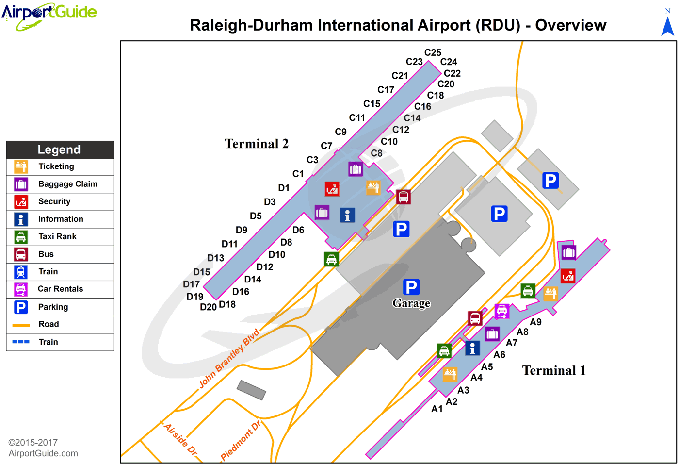
Maps & Diagrams
RDU Sectional
Flight Planning
at skyvector.com
at skyvector.com
 Diagram")