Location
Latitude: |
47-29-24.9000N (47.49025) |
Longitude: |
122-45-53.3000W (-122.764806) |
Elevation: |
444.0 feet MSL (135 m MSL) |
Magnetic Variation: |
15.3 E (as of April 2024 from WMM2020 model) |
Time Zone: |
UTC -8.0 (Standard Time) UTC -7.0 (Daylight Savings Time) |
From City: |
07 N.M. SW of Bremerton, Washington |
Found On: |
Seattle Chart |
FAA Region: |
ANM |
Contacts
Manager: |
Publicly owned: |
| MONROE WHITMAN 8850 SW STATE HIGHWAY 3 BREMERTON, WA 98312 (360) 813-0828 |
PORT OF BREMERTON 8850 SW STATE HIGHWAY 3 BREMERTON, WA 98312 (360) 674-2381 |
Operations
Airport Status: |
Operational |
Facility Use: |
Public |
Type: |
Airport |
Activation Date: |
12/1938 |
Control tower: |
No |
Attendance (Months/Days/Hours): |
Months/Days/Hours ALL/M-F/0800-1630 |
Boundary ARTCC: |
ZSE (Seattle) |
Responsible ARTCC: |
ZSE (Seattle) |
Lighting Schedule: |
SEE RMK |
Segmented Circle Indicator: |
Yes |
Traffic Pattern Altitude (MSL): |
1444 feet (440 m) |
NOTAMs Facility: |
PWT |
NOTAM-D Service: |
Yes |
International Airport of Entry: |
No |
Customs Landing Rights: |
No |
Military Landing Rights: |
Yes |
Civil/Military Joint Use: |
No |
Based Aircraft
| Single Engine: | 94 |
| Multi Engine: | 4 |
| Jet Engine: | 3 |
| GA Helicopters: | 2 |
| Gliders: | 1 |
Annual Operations (as of 12/31/2022)
| Total Operations: | 66000 | |
| Air Taxi: | 100 | 0.2% |
| GA Local: | 39000 | 59.1% |
| GA Itinerant: | 26000 | 39.4% |
| Military Aircraft: | 900 | 1.4% |
Communications
| CTAF: | 123.050 |
| Unicom: | 123.050 |
| Approach: | SEATTLE 120.1 120.1 120.1 120.1 |
| Departure: | SEATTLE 120.1 120.1 120.1 120.1 |
| AWOS-3PT: | 121.2 (360-674-2811) |
Fixed Based Operators (FBOs) & Fuel
(Click on a business for detail)
Please help us keep this information up to date. This is a FREE SERVICE just like everything else on Airport Guide! If you see that a business needs to be added, modified, or deleted please fill out our Update Form.
To add, modify, or delete a business click here.
Please help us keep this information up to date. This is a FREE SERVICE just like everything else on Airport Guide! If you see that a business needs to be added, modified, or deleted please fill out our Update Form.
Area Code: 360 |
| Business Name | Frequency | Phone | Fuel Grade |
|---|---|---|---|
| Airport Management
Update FBO info |
Unicom 123.05 | 674-2381 | 100ll, Jet A |
| Avian Aeronautics, Inc.
Update FBO info |
674-2244 | ||
| Peninsula Air Group
Update FBO info |
674-7099 |
Flight Service Stations
| Primary | Alternate | |
| FSS on Field: | N | |
| FSS Name (ID): | Seattle(SEA) | |
| Frequency: | ||
| Toll Free Phone: | 1-800-WX-BRIEF |
Instrument Procedures / Charts
FAA Terminal Procedures valid from 0901Z 03/21/24 to 0901Z 04/18/24.
There are various types of charts available for an airport. They are listed in the Page Type column. Here is a legend for those types:
APD - Airport Diagram
DP - Departure Procedure Charts
HOT - Hot Spots
IAP - Instrument Approach Procedure Charts
MIN - Minimums
STAR - Standard Terminal Arrival Charts
| Page Type | Page Name | Volume | Action Since Last Cycle |
|---|---|---|---|
| IAP | ILS OR LOC RWY 20 | NW-1 | |
| IAP | RNAV (GPS) RWY 02 | NW-1 | |
| IAP | RNAV (GPS) RWY 20 | NW-1 | |
| MIN | ALTERNATE MINIMUMS | NW-1 | |
| MIN | DIVERSE VECTOR AREA | NW-1 | |
| MIN | TAKEOFF MINIMUMS | NW-1 |
Terminal Procedures are only available for airports in several countries with more being added all the time. If you are looking for a specific country's charts, please send an email to support(at)airportguide.com stating the country name. This will be used to prioritize the implementation.
Navigation Aids (Navaids) near PWT
| Dist (NM) | ID | Morse Code | Name | Type | Freq | True Hdg | Mag Hdg |
|---|---|---|---|---|---|---|---|
| 0.4 | PWT | . _ _ . . _ _ _ | Kitsap | NDB | 206 | 69 | 54 |
| 5.6 | CAN | _ . _ . . _ _ . | Carney | NDB | 274 | 212 | 197 |
| 17.4 | BF | _ . . . . . _ . | Nolla | NDB | 362 | 60 | 45 |
| 18.7 | HPK | . . . . . _ _ . _ . _ | Parkk | NDB | 281 | 82 | 67 |
| 18.8 | SEA | . . . . . _ | Seattle | VORTAC | 116.80 | 99 | 84 |
| 18.8 | BFI | _ . . . . . _ . . . | Seattle | VOT | 108.60 | 82 | 67 |
| 18.9 | SEA | . . . . . _ | Seattle-Tacoma | VOT | 117.50 | 96 | 81 |
| 19.5 | MNC | _ _ _ . _ . _ . | Mason County | NDB | 348 | 222 | 207 |
| 21.4 | GRF | _ _ . . _ . . . _ . | Graye | NDB | 216 | 162 | 147 |
| 22.3 | RNT | . _ . _ . _ | Renton | NDB | 353 | 89 | 74 |
| 23.7 | TCM | _ _ . _ . _ _ | Mcchord | TACAN | 109.60 | 150 | 135 |
| 30.2 | LAC | . _ . . . _ _ . _ . | Lacomas | NDB | 328 | 163 | 148 |
| 31.6 | OLM | _ _ _ . _ . . _ _ | Olympia | VORTAC | 113.40 | 190 | 175 |
| 32.4 | PAE | . _ _ . . _ . | Paine | VOR-DME | 110.60 | 37 | 22 |
| 42.9 | AW | . _ . _ _ | Waton | NDB | 382 | 34 | 19 |
| 45.3 | CVV | _ . _ . . . . _ . . . _ | Penn Cove | VOR-DME | 117.20 | 2 | 347 |
| 46.7 | NOW | _ . _ _ _ . _ _ | Ediz Hook | NDB | 338 | 326 | 311 |
| 52.0 | NUW | _ . . . _ . _ _ | Whidbey Island | TACAN | 113.80 | 4 | 349 |
| 53.8 | CL | _ . _ . . _ . . | Elwha | NDB | 515 | 317 | 302 |
| 59.7 | OPZ | _ _ _ . _ _ . _ _ . . | Lopez Island | NDB | 356 | 354 | 339 |
Nearby Airports with Fuel
Notices to Airmen (NOTAMS)
Remarks
| A110*G | THIS AIRPORT HAS BEEN SURVEYED BY THE NATIONAL GEODETIC SURVEY. |
| A110-10 | FOR CD CTC SEATTLE APCH AT 206-214-4723. |
| A110-11 | WINTER WEATHER OPS AND REPORTING MON - FRI 8:00-16:30. |
| A110-9 | FENCE CROSSES N END OF ABND RWY. |
| A58-02 | +6 FT TRN 25 FT FM RWY END & 250 FT R. |
| A58-20 | +6 FT' FENCE 0 TO 200 FT FM RWY END 300 FT R. |
| A70-FUEL-10 | 0LL 24 HR FUEL TRML 300 FT WSW OF TWY A4, ONLY FOR 100LL. |
| A75 | PILOT MUST PRVD TIEDOWNS. |
| A81-APT | ACTVT MALSR RWY 20; REIL RWY 02; PAPI RWY 02; HIRL 02/20; TWY LGTS - CTAF. PAPI RWY 20 OPR CONSLY. |
| E111 | ESTABD PRIOR TO 1959. |
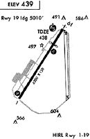
Runways
Runway Summary
| Runways: | 02/20 |
| Longest Runway: | 02/20 is 6000 ft (1829 m) long |
| Runways with an Instrument Approach: | 20 |
PWT Airport Runway Details
| Runway 02/20 | 6000 ft x 150 ft (1829 m x 46 m) | |
| Runway Length Source: | 3RD PARTY SURVEY as of 07/29/2016 | |
| Surface: | Asphalt - Good condition - Saw-cut or plastic grooved | |
| Runway Edge Lights: | High Intensity | |
Runway Weight Bearing Capacity (in thousands of pounds) |
||
| Single Wheel Landing Gear: | 66.0 | |
| Dual Wheel Landing Gear: | 150.0 | |
| Dual Tandem Wheel Landing Gear: | 336.0 | |
Runway 02 |
Runway 20 |
|
Elevation: |
444.0 | 441.5 |
Latitude: |
47-28-59.9779N | 47-29-49.7669N |
Longitude: |
122-46-16.9697W | 122-45-29.6862W |
|
Runway True Alignment: |
033 | 213 |
ILS Type: |
ILS | |
Glide Path Angle: |
3.0 degrees | 2.8 degrees |
Traffic Pattern: |
Right | Left |
Runway Markings Type: |
Nonprecision Instrument | Precision Instrument |
Runway Markings Condition: |
Good | Good |
Object at End: |
FENCE | |
Object Height: |
33 | |
Distance from End: |
1740 | |
Object Centerline Offset: |
300 ft. left of centerline | |
Visual Glide Slope Indicators: |
4-Light PAPI On Left Side Of Runway | 4-Light PAPI On Left Side Of Runway |
Approach Light System: |
1,400 Foot Medium Intensity Approach Lighting System With Runway Alignment Indicator Lights | |
REIL: |
Yes | |
Threshold Crossing Height: |
43 | 50 |
Services
Airframe Repair: |
Major |
Powerplant Repair: |
Major |
Bottled Oxygen: |
Low Pressure |
Bulk Oxygen: |
None |
Fuel Available: |
100LL, Jet A |
Landing Fees: |
No |
Parking: |
Tiedowns available |
Maps & Diagrams
PWT Sectional
Flight Planning
at skyvector.com
at skyvector.com