Location
Latitude: |
32-50-26.5000N (32.840694) |
Longitude: |
084-52-56.8000W (-84.882444) |
Elevation: |
902.0 feet MSL (275 m MSL) |
Magnetic Variation: |
5.1 W (as of April 2024 from WMM2020 model) |
Time Zone: |
UTC -5.0 (Standard Time) UTC -4.0 (Daylight Savings Time) |
From City: |
02 N.M. SW of Pine Mountain, Georgia |
Found On: |
Atlanta Chart |
FAA Region: |
ASO |
Contacts
Manager: |
Publicly owned: |
| RONALD PENDERGRASS 789 SKY MEADOW DRIVE PINE MOUNTAIN, GA 31822 706-663-2083 |
HARRIS COUNTY BOC COUNTY COURTHOUSE, 104 N. COLLEGE STREET HAMILTON, GA 31811 706-628-4958 |
Operations
Airport Status: |
Operational |
Facility Use: |
Public |
Type: |
Airport |
Control tower: |
No |
Attendance (Months/Days/Hours): |
Months/Days/Hours ALL/ALL/0900-1700 |
Boundary ARTCC: |
ZTL (Atlanta) |
Responsible ARTCC: |
ZTL (Atlanta) |
Lighting Schedule: |
SEE RMK |
Segmented Circle Indicator: |
Yes |
Traffic Pattern Altitude (MSL): |
1902 feet (580 m) |
NOTAMs Facility: |
MCN |
NOTAM-D Service: |
Yes |
International Airport of Entry: |
No |
Customs Landing Rights: |
No |
Military Landing Rights: |
Yes |
Civil/Military Joint Use: |
No |
Based Aircraft
| Single Engine: | 30 |
| Multi Engine: | 4 |
Annual Operations (as of 12/31/2021)
| Total Operations: | 18000 | |
| GA Local: | 9000 | 50.0% |
| GA Itinerant: | 9000 | 50.0% |
Communications
| CTAF: | 122.800 |
| Unicom: | 122.800 |
| Approach: | ATLANTA 125.5 125.5 125.5 125.5 125.5 ATLANTA ARTCC |
| Departure: | ATLANTA 125.5 125.5 125.5 125.5 125.5 ATLANTA ARTCC |
| AWOS-3PT: | 120.275 (706-663-2081) |
- ATLANTA LARGE TRACON PROVIDES APCH/DEP SVC 0615-2300 ON FREQ 125.5; ATLANTA ARTCC PROVIDES APCH/DEP SVC 2300-0615 ON FREQS 120.45/298.850 & CLNC DEL ON FREQ 120.45 (COLUMBUS RCAG).
Fixed Based Operators (FBOs) & Fuel
(Click on a business for detail)
Please help us keep this information up to date. This is a FREE SERVICE just like everything else on Airport Guide! If you see that a business needs to be added, modified, or deleted please fill out our Update Form.
To add, modify, or delete a business click here.
Please help us keep this information up to date. This is a FREE SERVICE just like everything else on Airport Guide! If you see that a business needs to be added, modified, or deleted please fill out our Update Form.
Area Code: 706 |
| Business Name | Frequency | Phone | Fuel Grade |
|---|---|---|---|
| Callaway Gardens Resort, Inc.
Update FBO info |
706-663-5055 |
Flight Service Stations
| Primary | Alternate | |
| FSS on Field: | N | |
| FSS Name (ID): | Macon(MCN) | |
| Frequency: | ||
| Toll Free Phone: | 1-800-WX-BRIEF |
Instrument Procedures / Charts
FAA Terminal Procedures valid from 0901Z 03/21/24 to 0901Z 04/18/24.
There are various types of charts available for an airport. They are listed in the Page Type column. Here is a legend for those types:
APD - Airport Diagram
DP - Departure Procedure Charts
HOT - Hot Spots
IAP - Instrument Approach Procedure Charts
MIN - Minimums
STAR - Standard Terminal Arrival Charts
| Page Type | Page Name | Volume | Action Since Last Cycle |
|---|---|---|---|
| IAP | RNAV (GPS) RWY 09 | SE-4 | |
| MIN | ALTERNATE MINIMUMS | SE-4 | |
| MIN | TAKEOFF MINIMUMS | SE-4 |
Terminal Procedures are only available for airports in several countries with more being added all the time. If you are looking for a specific country's charts, please send an email to support(at)airportguide.com stating the country name. This will be used to prioritize the implementation.
Navigation Aids (Navaids) near PIM
| Dist (NM) | ID | Morse Code | Name | Type | Freq | True Hdg | Mag Hdg |
|---|---|---|---|---|---|---|---|
| 0.5 | PIM | . _ _ . . . _ _ | Pine Mountain | NDB | 272 | 74 | 79 |
| 15.1 | CSG | _ . _ . . . . _ _ . | Columbus | TACAN | 117.10 | 206 | 211 |
| 20.5 | LGC | . _ . . _ _ . _ . _ . | Lagrange | VORTAC | 115.60 | 307 | 312 |
| 24.7 | CS | _ . _ . . . . | Fenix | NDB | 355 | 199 | 204 |
| 26.4 | EQQ | . _ _ . _ _ _ . _ | Coweta County | NDB | 234 | 18 | 23 |
| 31.0 | LSF | . _ . . . . . . . _ . | Lawson | VOR-DME | 111.40 | 190 | 195 |
| 33.6 | AWS | . _ . _ _ . . . | Lawson | NDB | 335 | 192 | 197 |
| 34.0 | FFC | . . _ . . . _ . _ . _ . | Pecat | NDB | 316 | 35 | 40 |
| 35.4 | OP | _ _ _ . _ _ . | Yates | NDB | 339 | 82 | 87 |
| 45.1 | TGE | _ _ _ . . | Tuskegee | VOR-DME | 117.30 | 241 | 246 |
| 45.3 | GPQ | _ _ . . _ _ . _ _ . _ | Carrollton | NDB | 278 | 344 | 349 |
| 52.3 | ATL | . _ _ . _ . . | Atlanta | DME | 116.9 | 25 | 30 |
| 52.6 | IZS | . . _ _ . . . . . | Montezuma | NDB | 426 | 122 | 127 |
| 53.1 | GSU | _ _ . . . . . . _ | Atlanta | DME | 116.9 | 26 | 31 |
| 54.1 | ATL | . _ _ . _ . . | Atlanta Muni | VOT | 111.00 | 24 | 29 |
| 54.4 | DER | _ . . . . _ . | Alexander City | NDB | 382 | 272 | 277 |
| 54.9 | EUF | . . . _ . . _ . | Eufaula | VORTAC | 109.20 | 193 | 198 |
| 56.0 | LKG | . _ . . _ . _ _ _ . | Lindbergh | NDB | 242 | 135 | 140 |
| 56.2 | BR | _ . . . . _ . | Redan | NDB | 266 | 30 | 35 |
| 56.6 | FT | . . _ . _ | Flanc | NDB | 344 | 12 | 17 |
Nearby Airports with Fuel
Notices to Airmen (NOTAMS)
Remarks
| A110-2 | GCO AVBL ON FREQ 121.725 THRU MCN CLEARANCE DELIVERY. |
| A16 | AFT HRS CALL 770-880-0765. |
| A70-FUEL-10 | 0LL FUEL 24 HR CREDIT CARD SVC AVBL. |
| A81-APT | ACTVT MIRL RY 09/27 & VASI RY 09 - CTAF. |
Runways
Runway Summary
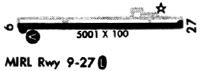
| Runways: | 09/27 |
| Longest Runway: | 09/27 is 5002 ft (1525 m) long |
| Runways with an Instrument Approach: |
PIM Airport Runway Details
| Runway 09/27 | 5002 ft x 100 ft (1525 m x 30 m) | |
| Runway Length Source: | 3RD PARTY SURVEY as of 07/29/2006 | |
| Surface: | Asphalt - Good condition - No special surface treatment | |
| Runway Edge Lights: | Medium Intensity | |
Runway Weight Bearing Capacity (in thousands of pounds) |
||
| Single Wheel Landing Gear: | 20.0 | |
Runway 09 |
Runway 27 |
|
Elevation: |
902.0 | 900.1 |
Latitude: |
32-50-25.8188N | 32-50-27.2041N |
Longitude: |
084-53-26.0707W | 084-52-27.4726W |
|
Runway True Alignment: |
088 | 268 |
Glide Path Angle: |
3.5 degrees | 3.0 degrees |
Traffic Pattern: |
Left | Left |
Runway Markings Type: |
Nonprecision Instrument | Nonprecision Instrument |
Runway Markings Condition: |
Good | Good |
Object at End: |
TREES | |
Object Height: |
52 | |
Distance from End: |
1240 | |
Object Centerline Offset: |
300 ft. right of centerline | |
Visual Glide Slope Indicators: |
4-Box VASI On Right Side Of Runway | 2-Light PAPI On Left Side Of Runway |
Threshold Crossing Height: |
31 | 35 |
Services
Airframe Repair: |
Major |
Powerplant Repair: |
Major |
Bottled Oxygen: |
High Pressure / Low Pressure |
Fuel Available: |
100LL, Jet A |
Landing Fees: |
No |
Parking: |
Hangars and tiedowns available |
Maps & Diagrams
PIM Sectional
Flight Planning
at skyvector.com
at skyvector.com