Location
Latitude: |
36-20-09.4000N (36.335944) |
Longitude: |
088-23-04.0000W (-88.384444) |
Elevation: |
580.2 feet MSL (177 m MSL) |
Magnetic Variation: |
3 W (as of April 2024 from WMM2020 model) |
Time Zone: |
UTC -6.0 (Standard Time) UTC -5.0 (Daylight Savings Time) |
From City: |
03 N.M. NW of Paris, Tennessee |
Found On: |
St Louis Chart |
FAA Region: |
ASO |
Contacts
Manager: |
Publicly owned: |
| BOBBY NOLAN 1949 DIGGS RD PARIS, TN 38242 731-644-7933 |
HENRY COUNTY P.O. BOX 7 PARIS, TN 38242 731-642-5212 |
Operations
Airport Status: |
Operational |
Facility Use: |
Public |
Type: |
Airport |
Activation Date: |
10/1946 |
Control tower: |
No |
Attendance (Months/Days/Hours): |
Months/Days/Hours ALL/MON-FRI/0800-1630 |
Boundary ARTCC: |
ZME (Memphis) |
Responsible ARTCC: |
ZME (Memphis) |
Lighting Schedule: |
SEE RMK |
Segmented Circle Indicator: |
Yes |
Traffic Pattern Altitude (MSL): |
1580 feet (482 m) |
NOTAMs Facility: |
MKL |
NOTAM-D Service: |
Yes |
International Airport of Entry: |
No |
Customs Landing Rights: |
No |
Military Landing Rights: |
Yes |
Civil/Military Joint Use: |
No |
Based Aircraft
| Single Engine: | 13 |
| Multi Engine: | 1 |
| Jet Engine: | 1 |
| GA Helicopters: | 3 |
Annual Operations (as of 05/24/2023)
| Total Operations: | 5830 | |
| GA Local: | 3000 | 51.5% |
| GA Itinerant: | 2800 | 48.0% |
| Military Aircraft: | 30 | 0.5% |
Communications
| CTAF: | 123.000 |
| Unicom: | 123.000 |
| AWOS-3: | 118.825 (731-644-0451) |
- APCH/DEP SVC PRVDD BY MEMPHIS ARTCC ON FREQS 134.65/316.15 (MCKELLAR RCAG).
Fixed Based Operators (FBOs) & Fuel
(Click on a business for detail)
Please help us keep this information up to date. This is a FREE SERVICE just like everything else on Airport Guide! If you see that a business needs to be added, modified, or deleted please fill out our Update Form.
To add, modify, or delete a business click here.
Please help us keep this information up to date. This is a FREE SERVICE just like everything else on Airport Guide! If you see that a business needs to be added, modified, or deleted please fill out our Update Form.
Area Code: 731 |
| Business Name | Frequency | Phone | Fuel Grade |
|---|---|---|---|
| Battles Aviation
Update FBO info |
Unicom 123.0 | 642-7676 | 100LL, Jet A |
Flight Service Stations
| Primary | Alternate | |
| FSS on Field: | N | |
| FSS Name (ID): | Jackson(MKL) | |
| Frequency: | ||
| Toll Free Phone: | 1-800-WX-BRIEF |
Instrument Procedures / Charts
FAA Terminal Procedures valid from 0901Z 03/21/24 to 0901Z 04/18/24.
There are various types of charts available for an airport. They are listed in the Page Type column. Here is a legend for those types:
APD - Airport Diagram
DP - Departure Procedure Charts
HOT - Hot Spots
IAP - Instrument Approach Procedure Charts
MIN - Minimums
STAR - Standard Terminal Arrival Charts
| Page Type | Page Name | Volume | Action Since Last Cycle |
|---|---|---|---|
| IAP | RNAV (GPS) RWY 02 | SE-1 | |
| IAP | RNAV (GPS) RWY 20 | SE-1 | |
| MIN | ALTERNATE MINIMUMS | SE-1 | |
| MIN | TAKEOFF MINIMUMS | SE-1 |
Terminal Procedures are only available for airports in several countries with more being added all the time. If you are looking for a specific country's charts, please send an email to support(at)airportguide.com stating the country name. This will be used to prioritize the implementation.
Navigation Aids (Navaids) near PHT
| Dist (NM) | ID | Morse Code | Name | Type | Freq | True Hdg | Mag Hdg |
|---|---|---|---|---|---|---|---|
| 5.4 | TIQ | _ . . _ _ . _ | Trainer | NDB | 410 | 196 | 199 |
| 15.4 | HZD | . . . . _ _ . . _ . . | Huntingdon | NDB | 217 | 195 | 198 |
| 23.5 | EU | . . . _ | Murey | NDB | 368 | 11 | 14 |
| 29.6 | UC | . . _ _ . _ . | Obion | NDB | 212 | 265 | 268 |
| 33.8 | AEY | . _ . _ . _ _ | Waverly | NDB | 329 | 112 | 115 |
| 44.2 | JKS | . _ _ _ _ . _ . . . | Jacks Creek | VOR-DME | 109.40 | 178 | 181 |
| 45.9 | CNG | _ . _ . _ . _ _ . | Cunningham | VOR-DME | 113.10 | 331 | 334 |
| 46.4 | HXW | . . . . _ . . _ . _ _ | Screaming Eagle | TACAN | 114.90 | 65 | 68 |
| 47.7 | DMZ | _ . . _ _ _ _ . . | Dickson | NDB | 203 | 104 | 107 |
| 49.0 | DYR | _ . . _ . _ _ . _ . | Dyersburg | TACAN | 116.80 | 247 | 250 |
| 49.5 | CK | _ . _ . _ . _ | Snuff | NDB | 335 | 76 | 79 |
| 49.9 | CKV | _ . _ . _ . _ . . . _ | Clarksville | VOR-DME | 110.60 | 69 | 72 |
| 50.5 | BDD | _ . . . _ . . _ . . | Bellgrade | NDB | 254 | 344 | 347 |
| 50.8 | MKL | _ _ _ . _ . _ . . | Mc Kellar | VOR-DME | 112.00 | 210 | 213 |
| 52.6 | FK | . . _ . _ . _ | Airbe | NDB | 273 | 62 | 65 |
| 54.3 | GHM | _ _ . . . . . _ _ | Graham | DME | 111.6 | 123 | 126 |
| 55.9 | CHQ | _ . _ . . . . . _ _ . _ | Charleston | NDB | 208 | 303 | 306 |
| 56.5 | MKL | _ _ _ . _ . _ . . | Mersy | NDB | 394 | 209 | 212 |
| 59.3 | CIR | _ . _ . . . . _ . | Cairo | NDB | 397 | 317 | 320 |
| 60.1 | HIX | . . . . . . _ . . _ | Honey Grove | NDB | 356 | 56 | 59 |
Nearby Airports with Fuel
Notices to Airmen (NOTAMS)
Remarks
| A110-2 | ULTRALIGHTS ARE NOT TO CROSS RWY 02/20. |
| A110-3 | PARALLEL TWY UNLGTD. |
| A110-4 | FOR CD CTC MEMPHIS ARTCC AT 901-368-8453/8449. |
| A16 | AFT HR 731-644-1643/731-363-4732. |
| A17 | ARPT UNATNDD THANKSGIVING; CHRISTMAS; NEW YEARS & FEDERAL HOLIDAYS. |
| A40-02/20 | L.E.D |
| A43-02 | PAPI UNUSBL BYD 8 DEG RIGHT & 8 DEG LEFT OF CNTRLN. |
| A43-20 | PAPI UNUSBL BYD 9 DEG RIGHT OF CNTRLN. |
| A81-APT | REIL RWY 02/20; MIRL RWY 02/20 OPR DUSK-DAWN. PAPI RWY 02/20 OPR CONSLY. |
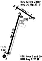
Runways
Runway Summary
| Runways: | 02/20 |
| Longest Runway: | 02/20 is 5001 ft (1524 m) long |
| Runways with an Instrument Approach: |
PHT Airport Runway Details
| Runway 02/20 | 5001 ft x 100 ft (1524 m x 30 m) | |
| Runway Length Source: | 3RD PARTY SURVEY as of 06/16/2008 | |
| Surface: | Asphalt - Good condition - No special surface treatment | |
| Runway Pavement Class: | 10 /F/D/X/T | |
| Runway Edge Lights: | Medium Intensity | |
Runway Weight Bearing Capacity (in thousands of pounds) |
||
| Single Wheel Landing Gear: | 17.0 | |
Runway 02 |
Runway 20 |
|
Elevation: |
580.2 | 568.0 |
Latitude: |
36-19-45.6800N | 36-20-33.1400N |
Longitude: |
088-23-12.6100W | 088-22-55.3700W |
|
Runway True Alignment: |
016 | 196 |
Glide Path Angle: |
3.0 degrees | 3.0 degrees |
Traffic Pattern: |
Left | Left |
Runway Markings Type: |
Precision Instrument | Precision Instrument |
Runway Markings Condition: |
Good | Good |
Object Height: |
0 | |
Distance from End: |
0 | |
Object Centerline Offset: |
0 ft. left and right of centerline | |
Visual Glide Slope Indicators: |
4-Light PAPI On Left Side Of Runway | 4-Light PAPI On Left Side Of Runway |
REIL: |
Yes | Yes |
Threshold Crossing Height: |
26 | 21 |
Services
Airframe Repair: |
Major |
Powerplant Repair: |
Major |
Fuel Available: |
100LL, Jet A+ |
Landing Fees: |
No |
Parking: |
Hangars and tiedowns available |
Maps & Diagrams
PHT Sectional
Flight Planning
at skyvector.com
at skyvector.com