Location
Latitude: |
43-59-03.7350N (43.984371) |
Longitude: |
088-33-25.3530W (-88.557043) |
Elevation: |
808.5 feet MSL (246 m MSL) |
Magnetic Variation: |
3.7 W (as of April 2024 from WMM2020 model) |
Time Zone: |
UTC -6.0 (Standard Time) UTC -5.0 (Daylight Savings Time) |
From City: |
02 N.M. S of Oshkosh, Wisconsin |
Found On: |
Chicago Chart |
FAA Region: |
AGL |
Contacts
Manager: |
Publicly owned: |
| JAMES SCHELL 525 W 20TH AVE OSHKOSH, WI 54902 920-236-4930 |
WINNEBAGO COUNTY 415 JACKSON ST OSHKOSH, WI 54901 920-236-4930 |
Operations
Airport Status: |
Operational |
Facility Use: |
Public |
Type: |
Airport |
Activation Date: |
10/1937 |
Control tower: |
Yes |
Attendance (Months/Days/Hours): |
Months/Days/Hours ALL/ALL/0700-2000 |
Boundary ARTCC: |
ZAU (Chicago) |
Responsible ARTCC: |
ZAU (Chicago) |
Lighting Schedule: |
SEE RMK |
Segmented Circle Indicator: |
No |
Traffic Pattern Altitude (MSL): |
1808 feet (551 m) |
NOTAMs Facility: |
OSH |
NOTAM-D Service: |
Yes |
International Airport of Entry: |
No |
Customs Landing Rights: |
No |
Military Landing Rights: |
Yes |
Civil/Military Joint Use: |
No |
Based Aircraft
| Single Engine: | 129 |
| Multi Engine: | 27 |
| Jet Engine: | 11 |
| GA Helicopters: | 1 |
Annual Operations (as of 12/31/2021)
| Total Operations: | 80102 | |
| Air Taxi: | 2281 | 2.8% |
| GA Local: | 36185 | 45.2% |
| GA Itinerant: | 41216 | 51.5% |
| Military Aircraft: | 420 | 0.5% |
Communications
| CTAF: | 118.500 |
| Unicom: | 122.950 |
| Tower: | OSHKOSH 118.5 290.9 Hrs: 0600-2200 |
| Ground: | 132.3 |
| Approach: | MILWAUKEE 127.0 127.0 |
| Departure: | MILWAUKEE 127.0 127.0 |
| ATIS: | 125.9 Hrs: 24 |
| ASOS: | (920-426-1644) |
| EMERG: | 121.5 |
| EMERG: | 243.0 |
Fixed Based Operators (FBOs) & Fuel
(Click on a business for detail)
Please help us keep this information up to date. This is a FREE SERVICE just like everything else on Airport Guide! If you see that a business needs to be added, modified, or deleted please fill out our Update Form.
To add, modify, or delete a business click here.
Please help us keep this information up to date. This is a FREE SERVICE just like everything else on Airport Guide! If you see that a business needs to be added, modified, or deleted please fill out our Update Form.
Area Code: 920 |
| Business Name | Frequency | Phone | Fuel Grade |
|---|---|---|---|
| Aviation Services Company
Update FBO info |
426-3131 | ||
| Basler Flight Service
Update FBO info |
Unicom 122.95 | 236-7827 | 80, 100LL, Jet A |
| Basler Turbo Conversions
Update FBO info |
236-7820 | ||
| EAA Aviation Foundation
Update FBO info |
426-4888 | ||
| Experimental Aircraft Association
Update FBO info |
426-4800 | ||
| Myers Aviation, Inc.
Update FBO info |
231-9772 | ||
| Slater's Aircraft Interiors
Update FBO info |
231-1921 | ||
| Valley Aviation
Update FBO info |
233-2202 | 100LL |
Flight Service Stations
| Primary | Alternate | |
| FSS on Field: | N | |
| FSS Name (ID): | Green Bay(GRB) | |
| Frequency: | ||
| Toll Free Phone: | 1-800-WX-BRIEF |
Instrument Procedures / Charts
FAA Terminal Procedures valid from 0901Z 03/21/24 to 0901Z 04/18/24.
There are various types of charts available for an airport. They are listed in the Page Type column. Here is a legend for those types:
APD - Airport Diagram
DP - Departure Procedure Charts
HOT - Hot Spots
IAP - Instrument Approach Procedure Charts
MIN - Minimums
STAR - Standard Terminal Arrival Charts
| Page Type | Page Name | Volume | Action Since Last Cycle |
|---|---|---|---|
| APD | AIRPORT DIAGRAM | EC-3 | |
| HOT | HOT SPOT | EC-3 | |
| IAP | ILS OR LOC RWY 36 | EC-3 | |
| IAP | LOC/DME BC RWY 18 | EC-3 | |
| IAP | NDB RWY 36 | EC-3 | |
| IAP | RNAV (GPS) RWY 09 | EC-3 | |
| IAP | RNAV (GPS) RWY 18 | EC-3 | |
| IAP | RNAV (GPS) RWY 27 | EC-3 | |
| IAP | RNAV (GPS) RWY 36 | EC-3 | |
| IAP | VOR RWY 09 | EC-3 | |
| IAP | VOR RWY 18 | EC-3 | |
| IAP | VOR RWY 27 | EC-3 | |
| IAP | VOR RWY 36 | EC-3 | |
| MIN | ALTERNATE MINIMUMS | EC-3 | |
| MIN | TAKEOFF MINIMUMS | EC-3 |
Terminal Procedures are only available for airports in several countries with more being added all the time. If you are looking for a specific country's charts, please send an email to support(at)airportguide.com stating the country name. This will be used to prioritize the implementation.
Navigation Aids (Navaids) near OSH
| Dist (NM) | ID | Morse Code | Name | Type | Freq | True Hdg | Mag Hdg |
|---|---|---|---|---|---|---|---|
| 0.4 | OSH | _ _ _ . . . . . . . | Oshkosh | VORTAC | 116.75 | 7 | 11 |
| 6.6 | OS | _ _ _ . . . | Pober | NDB | 395 | 180 | 184 |
| 10.8 | AT | . _ _ | Gamie | NDB | 230 | 353 | 357 |
| 15.5 | AQ | . _ _ _ . _ | Kooky | NDB | 407 | 26 | 30 |
| 28.9 | PCZ | . _ _ . _ . _ . _ _ . . | Waupaca | NDB | 382 | 316 | 320 |
| 30.6 | GR | _ _ . . _ . | Famis | NDB | 356 | 26 | 30 |
| 30.8 | SG | . . . _ _ . | Depre | NDB | 332 | 36 | 40 |
| 33.3 | FAH | . . _ . . _ . . . . | Falls | DME | 110 | 112 | 116 |
| 33.9 | UNU | . . _ _ . . . _ | Juneau | NDB | 344 | 190 | 194 |
| 37.6 | GRB | _ _ . . _ . _ . . . | Green Bay | VORTAC | 115.50 | 24 | 28 |
| 38.6 | BJB | _ . . . . _ _ _ _ . . . | West Bend | VOR | 109.80 | 150 | 154 |
| 38.8 | MTW | _ _ _ . _ _ | Manitowoc | DME | 111 | 76 | 80 |
| 38.8 | CLI | _ . _ . . _ . . . . | Clintonville | NDB | 209 | 348 | 352 |
| 39.0 | MT | _ _ _ | Mawoc | NDB | 362 | 70 | 74 |
| 49.2 | RYV | . _ . _ . _ _ . . . _ | Rock River | NDB | 371 | 188 | 192 |
| 53.4 | BAE | _ . . . . _ . | Badger | VOR-DME | 116.40 | 167 | 171 |
| 53.6 | STE | . . . _ . | Stevens Point | VORTAC | 110.60 | 309 | 312 |
| 57.1 | LJT | . _ . . . _ _ _ _ | Timmerman | DME | 115.65 | 156 | 160 |
| 58.4 | DLL | _ . . . _ . . . _ . . | Dells | VORTAC | 117.00 | 243 | 246 |
| 59.6 | EK | . _ . _ | Nepco | NDB | 326 | 286 | 289 |
Nearby Airports with Fuel
Notices to Airmen (NOTAMS)
Remarks
| A110-10 | FOR CD IF UNA TO CTC ON FSS FREQ, CTC CHICAGO ARTCC AT 630-906-8921. |
| A110-11 | SFC CONDS NOT MONTRD BTWN 2200 - 0500 HRS. |
| A110-4 | BIRDS ON & INVOF ARPT. |
| A110-8 | RWYS 13/31, 05/23 & TWYS C, H, P NOT AVBL TO ACFT WITH MORE THAN 30 PSGR SEATS. |
| A110-9 | RY 23 & RY 27 APCH ENDS ARE CLOSELY ALIGNED. VERIFY CORRECT RY AND COMPASS HEADING PRIOR TO DEP. |
| A15 | EMAIL ADDRESS: JSCHELL@WINNEBAGOCOUNTYWI.GOV (ALL LOWER CASE). |
| A17 | FOR ARPT ATTENDANT OTR HRS CALL 920-236-7827. |
| A35-05/23 | MAXIMUM WEIGHT BEARING CAPACITY FOR ANY ACFT IS 50000 LBS. |
| A35-13/31 | MAXIMUM WEIGHT BEARING CAPACITY FOR ANY ACFT IS 50000 LBS. |
| A57-27 | APCH RATIO 34:1 TO DSPLCD THR. |
| A70-FUEL-A+ | A+ AND 100LL AVBL 0700-1900++ MON-FRI, 0800-1700++ SAT-SUN, C920-236-7827 (AFTER HRS FEE $50). |
| A81-APT | ACTVT MALSR RWY 36; HIRL RWY 09/27 - CTAF. HIRL 18/36 PRESET ON MED INTST, TO INCR INTST & ACTVT - CTAF. PAPI RWY 09, 27, 18 & 36 OPR CONSLY. |
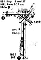
Runways
Runway Summary
| Runways: | 05/23 09/27 13/31 18/36 |
| Longest Runway: | 18/36 is 8002 ft (2439 m) long |
| Runways with an Instrument Approach: | 36 |
OSH Airport Runway Details
| Runway 05/23 | 3424 ft x 75 ft (1044 m x 23 m) | |
| Runway Length Source: | 3RD PARTY SURVEY as of 11/06/2019 | |
| Surface: | Asphalt - Fair condition - No special surface treatment | |
Runway 05 |
Runway 23 |
|
Elevation: |
790.3 | 775.2 |
Latitude: |
43-59-11.9338N | 43-59-35.8792N |
Longitude: |
088-33-30.0000W | 088-32-56.9410W |
|
Runway True Alignment: |
045 | 225 |
Glide Path Angle: |
0.0 degrees | 0.0 degrees |
Traffic Pattern: |
Left | Left |
Runway Markings Type: |
Basic | Basic |
Runway Markings Condition: |
Good | Good |
REIL: |
No | No |
Touchdown Lights: |
No | No |
Centerline Lights: |
No | No |
| Runway 09/27 | 6179 ft x 150 ft (1883 m x 46 m) | |
| Runway Length Source: | 3RD PARTY SURVEY as of 11/06/2019 | |
| Surface: | Asphalt - Fair condition - Saw-cut or plastic grooved | |
| Runway Edge Lights: | High Intensity | |
Runway Weight Bearing Capacity (in thousands of pounds) |
||
| Single Wheel Landing Gear: | 75.0 | |
| Dual Wheel Landing Gear: | 125.0 | |
| Dual Tandem Wheel Landing Gear: | 185.0 | |
Runway 09 |
Runway 27 |
|
Elevation: |
797.5 | 775.8 |
Latitude: |
43-59-29.8979N | 43-59-29.3119N |
Longitude: |
088-34-19.6686W | 088-32-55.1503W |
|
Runway True Alignment: |
091 | 271 |
Glide Path Angle: |
3.0 degrees | 3.0 degrees |
Traffic Pattern: |
Left | Left |
Runway Markings Type: |
Nonprecision Instrument | Nonprecision Instrument |
Runway Markings Condition: |
Good | Good |
Object at End: |
TREE | |
Object Height: |
39 | |
Distance from End: |
750 | |
Visual Glide Slope Indicators: |
4-Light PAPI On Left Side Of Runway | 4-Light PAPI On Left Side Of Runway |
REIL: |
No | Yes |
Touchdown Lights: |
No | No |
Centerline Lights: |
No | No |
Threshold Crossing Height: |
50 | 47 |
Threshold Elevation: |
777.8 | |
Displaced Threshold: |
531 | |
Threshold Latitude: |
43-59-29.3629N | |
Threshold Longitude: |
088-33-02.4152W | |
Declared Distances |
||
Take Off Run Avbl. (TORA): |
6179 | 6179 |
Take Off Distance Avbl. (TODA): |
6179 | 6179 |
Actual Stop Dist. Avbl. (ASDA): |
5648 | 6179 |
Landing Dist. Avbl. (LDA): |
5648 | 5648 |
| Runway 13/31 | 3061 ft x 75 ft (933 m x 23 m) | |
| Runway Length Source: | 3RD PARTY SURVEY as of 11/06/2019 | |
| Surface: | Asphalt - Fair condition - No special surface treatment | |
Runway 13 |
Runway 31 |
|
Elevation: |
781.7 | 781.2 |
Latitude: |
43-59-28.4788N | 43-59-09.2828N |
Longitude: |
088-33-34.9185W | 088-33-02.5697W |
|
Runway True Alignment: |
129 | 309 |
Glide Path Angle: |
0.0 degrees | 0.0 degrees |
Traffic Pattern: |
Left | Left |
Runway Markings Type: |
Basic | Basic |
Runway Markings Condition: |
Good | Good |
Object at End: |
ROAD | |
Object Height: |
15 | |
Distance from End: |
217 | |
REIL: |
No | No |
Touchdown Lights: |
No | No |
Centerline Lights: |
No | No |
| Runway 18/36 | 8002 ft x 150 ft (2439 m x 46 m) | |
| Runway Length Source: | 3RD PARTY SURVEY as of 11/06/2019 | |
| Surface: | Asphalt - Fair condition - Saw-cut or plastic grooved | |
| Runway Edge Lights: | High Intensity | |
Runway Weight Bearing Capacity (in thousands of pounds) |
||
| Single Wheel Landing Gear: | 65.0 | |
| Dual Wheel Landing Gear: | 85.0 | |
| Dual Tandem Wheel Landing Gear: | 130.0 | |
Runway 18 |
Runway 36 |
|
Elevation: |
789.6 | 808.4 |
Latitude: |
43-59-08.8403N | 43-57-49.8233N |
Longitude: |
088-33-23.1384W | 088-33-24.1752W |
|
Runway True Alignment: |
181 | 001 |
ILS Type: |
ILS | |
Glide Path Angle: |
3.0 degrees | 3.0 degrees |
Traffic Pattern: |
Left | Left |
Runway Markings Type: |
Precision Instrument | Precision Instrument |
Runway Markings Condition: |
Good | Good |
Object at End: |
ANT | |
Object Height: |
15 | |
Distance from End: |
550 | |
Visual Glide Slope Indicators: |
4-Light PAPI On Left Side Of Runway | 4-Light PAPI On Left Side Of Runway |
Runway Visual Range (RVR): |
Rollout | Touchdown |
Approach Light System: |
1,400 Foot Medium Intensity Approach Lighting System With Runway Alignment Indicator Lights | |
REIL: |
Yes | No |
Touchdown Lights: |
No | No |
Centerline Lights: |
No | No |
Threshold Crossing Height: |
47 | 52 |
Services
Airframe Repair: |
None |
Powerplant Repair: |
None |
Bottled Oxygen: |
None |
Bulk Oxygen: |
None |
Fuel Available: |
100LL |
Landing Fees: |
No |
Parking: |
Hangars and tiedowns available |
Maps & Diagrams
OSH Sectional
Flight Planning
at skyvector.com
at skyvector.com