Location
Latitude: |
40-48-42.2320N (40.811731) |
Longitude: |
077-39-25.9900W (-77.657219) |
Elevation: |
1307.0 feet MSL (398 m MSL) |
Magnetic Variation: |
10.7 W (as of April 2024 from WMM2020 model) |
Time Zone: |
UTC -5.0 (Standard Time) UTC -4.0 (Daylight Savings Time) |
From City: |
02 N.M. SE of Centre Hall, Pennsylvania |
Found On: |
Detroit Chart |
FAA Region: |
AEA |
Contacts
Manager: |
Privately owned: |
| JOE HENRY GARBRICK 458 AIRPORT ROAD CENTRE HALL, PA 16828 (814) 364-9188 |
JOE HENRY GARBRICK 386 AIRPORT ROAD CENTRE HALL, PA 16828 814-364-1403 |
Operations
Airport Status: |
Operational |
Facility Use: |
Public |
Type: |
Airport |
Activation Date: |
08/1962 |
Control tower: |
No |
Attendance (Months/Days/Hours): |
Months/Days/Hours ALL/ALL/IREG |
Boundary ARTCC: |
ZNY (New York) |
Responsible ARTCC: |
ZNY (New York) |
Segmented Circle Indicator: |
No |
Traffic Pattern Altitude (MSL): |
2307 feet (703 m) |
NOTAMs Facility: |
AOO |
NOTAM-D Service: |
Yes |
International Airport of Entry: |
No |
Customs Landing Rights: |
No |
Military Landing Rights: |
No |
Civil/Military Joint Use: |
No |
Based Aircraft
| Single Engine: | 7 |
| Multi Engine: | 1 |
| Ultralights: | 4 |
Annual Operations (as of 01/31/2024)
| Total Operations: | 1600 | |
| GA Local: | 1500 | 93.8% |
| GA Itinerant: | 100 | 6.2% |
Communications
| CTAF: | 122.700 |
| Unicom: | 122.700 |
Fixed Based Operators (FBOs) & Fuel
(Click on a business for detail)
Please help us keep this information up to date. This is a FREE SERVICE just like everything else on Airport Guide! If you see that a business needs to be added, modified, or deleted please fill out our Update Form.
To add, modify, or delete a business click here.
Please help us keep this information up to date. This is a FREE SERVICE just like everything else on Airport Guide! If you see that a business needs to be added, modified, or deleted please fill out our Update Form.
Area Code: 814 |
| Business Name | Frequency | Phone | Fuel Grade |
|---|---|---|---|
| Centre Airpark
Update FBO info |
364-1153 | 100LL |
Flight Service Stations
| Primary | Alternate | |
| FSS on Field: | N | |
| FSS Name (ID): | Altoona(AOO) | |
| Frequency: | ||
| Toll Free Phone: | 1-800-WX-BRIEF |
Instrument Procedures / Charts
Terminal Procedures are only available for airports in several countries with more being added all the time. If you are looking for a specific country's charts, please send an email to support(at)airportguide.com stating the country name. This will be used to prioritize the implementation.
Navigation Aids (Navaids) near N16
| Dist (NM) | ID | Morse Code | Name | Type | Freq | True Hdg | Mag Hdg |
|---|---|---|---|---|---|---|---|
| 7.0 | UN | . . _ _ . | Penue | NDB | 388 | 327 | 338 |
| 16.5 | PSB | . _ _ . . . . _ . . . | Philipsburg | VORTAC | 115.50 | 292 | 303 |
| 31.0 | TON | _ _ _ _ _ . | Tyrone | VORTAC | 114.90 | 261 | 272 |
| 32.7 | ETG | . _ _ _ . | Keating | VORTAC | 116.00 | 317 | 328 |
| 35.1 | SEG | . . . . _ _ . | Selinsgrove | VOR-DME | 110.40 | 91 | 102 |
| 40.6 | HAR | . . . . . _ . _ . | Harrisburg | VORTAC | 112.50 | 138 | 149 |
| 41.5 | AOO | . _ _ _ _ _ _ _ | Altoona | VOR | 108.80 | 225 | 236 |
| 44.4 | SLT | . . . . _ . . _ | Slate Run | VORTAC | 113.90 | 341 | 352 |
| 46.7 | MIP | _ _ . . . _ _ . | Milton | VORTAC | 109.20 | 73 | 84 |
| 48.3 | CX | _ . _ . _ . . _ | Latle | NDB | 219 | 141 | 152 |
| 48.4 | MD | _ _ _ . . | Enola | NDB | 204 | 134 | 145 |
| 50.6 | RAV | . _ . . _ . . . _ | Ravine | VORTAC | 114.60 | 107 | 118 |
| 50.9 | FQM | . . _ . _ _ . _ _ _ | Williamsport | VOR-DME | 114.40 | 51 | 62 |
| 51.2 | PIX | . _ _ . . . _ . . _ | Picture Rocks | NDB | 344 | 56 | 67 |
| 52.1 | REC | . _ . . _ . _ . | Revloc | VOR-DME | 110.60 | 252 | 262 |
| 54.1 | SFK | . . . . . _ . _ . _ | Stonyfork | VOR-DME | 108.60 | 11 | 22 |
| 54.4 | THS | _ . . . . . . . | St Thomas | VORTAC | 115.00 | 194 | 205 |
| 55.0 | MDT | _ _ _ . . _ | Harrisburg | VOT | 110.00 | 131 | 142 |
| 55.1 | BZJ | _ . . . _ _ . . . _ _ _ | Bellgrove | NDB | 328 | 113 | 124 |
| 61.3 | JST | . _ _ _ . . . _ | Johnstown | VOR-DME | 113.00 | 241 | 251 |
Nearby Airports with Fuel
Notices to Airmen (NOTAMS)
Remarks
| A110-3 | ULTRALIGHT ACTIVITY ON & INVOF ARPT. |
| A110-4 | RY 06/24 NOT MAINTAINED WINTER MOS. |
| A110-5 | RC AIRPLANE OPERATIONS ON & INVOF AIRPORT. |
| A110-6 | FOR CD CTC NEW YORK ARTCC AT 631-468-1425. |
| A17 | FOR SVC AFTER HRS CALL 570-419-7509. |
| A42-06 | RWY 06 THR UNMKD. DTHR MKD AT 720 FT. |
| A42-24 | RWY 24 THR UNMKD. DTHR MKD AT 610 FT. |
| A57-06 | APCH SLOPE 20:1 TO DSPLCD THLD. |
| A57-24 | APCH SLOPE 22:1 TO DSPLCD THLD. |
| E111 | VFR USE ONLY |
Runways
Runway Summary
| Runways: | 06/24 |
| Longest Runway: | 06/24 is 3100 ft (945 m) long |
| Runways with an Instrument Approach: |
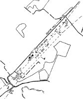
N16 Airport Runway Details
| Runway 06/24 | 3100 ft x 210 ft (945 m x 64 m) | |
| Surface: | Turf - Good condition - No special surface treatment | |
Runway 06 |
Runway 24 |
|
Glide Path Angle: |
0.0 degrees | 0.0 degrees |
Traffic Pattern: |
Left | Left |
Object at End: |
ROAD | TREES |
Object Height: |
15 | 57 |
Distance from End: |
5 | 525 |
Object Centerline Offset: |
0 ft. left and right of centerline | 127 ft. right of centerline |
Displaced Threshold: |
400 | 400 |
Services
Airframe Repair: |
Major |
Powerplant Repair: |
Major |
Bottled Oxygen: |
None |
Bulk Oxygen: |
None |
Fuel Available: |
100LL |
Landing Fees: |
No |
Parking: |
Tiedowns available |
Maps & Diagrams
N16 Sectional
Flight Planning
at skyvector.com
at skyvector.com