Location
Latitude: |
39-56-03.4000N (39.934278) |
Longitude: |
074-48-26.0000W (-74.807222) |
Elevation: |
49.3 feet MSL (15 m MSL) |
Magnetic Variation: |
12.1 W (as of April 2024 from WMM2020 model) |
Time Zone: |
UTC -5.0 (Standard Time) UTC -4.0 (Daylight Savings Time) |
From City: |
01 N.M. SW of Lumberton, New Jersey |
Found On: |
Washington Chart |
FAA Region: |
AEA |
Contacts
Manager: |
Privately owned: |
| MINDY KIMBALL 60 FOSTERTOWN RD MEDFORD, NJ 08055 609-267-7673 |
CAVE HOLDINGS-FLYING W, LLC 60 FOSTERTOWN RD MEDFORD, NJ 08055 609-261-7880 |
Operations
Airport Status: |
Operational |
Facility Use: |
Public |
Type: |
Airport |
Activation Date: |
04/1984 |
Control tower: |
No |
Attendance (Months/Days/Hours): |
Months/Days/Hours APR-OCT/ALL/0700-2100 |
Boundary ARTCC: |
ZDC (Washington) |
Responsible ARTCC: |
ZNY (New York) |
Lighting Schedule: |
SEE RMK |
Segmented Circle Indicator: |
Yes |
Traffic Pattern Altitude (MSL): |
1049 feet (320 m) |
NOTAMs Facility: |
MIV |
NOTAM-D Service: |
Yes |
Based Aircraft
| Single Engine: | 85 |
| Multi Engine: | 5 |
| GA Helicopters: | 5 |
Annual Operations (as of 07/14/2023)
| Total Operations: | 34651 | |
| GA Local: | 23576 | 68.0% |
| GA Itinerant: | 11075 | 32.0% |
Communications
| CTAF: | 122.800 |
| Unicom: | 122.800 |
| Approach: | MC GUIRE 126.475 126.475 |
| Departure: | MC GUIRE 126.475 126.475 |
Fixed Based Operators (FBOs) & Fuel
(Click on a business for detail)
Please help us keep this information up to date. This is a FREE SERVICE just like everything else on Airport Guide! If you see that a business needs to be added, modified, or deleted please fill out our Update Form.
To add, modify, or delete a business click here.
Please help us keep this information up to date. This is a FREE SERVICE just like everything else on Airport Guide! If you see that a business needs to be added, modified, or deleted please fill out our Update Form.
Area Code: 609 |
| Business Name | Frequency | Phone | Fuel Grade |
|---|---|---|---|
| Aero Prep Institute, Inc.
Update FBO info |
265-9139, 267-0888 | 100LL, Jet A | |
| Air-1 Flight School
Update FBO info |
267-6463 | 100LL | |
| Ikaros Aviation International
Update FBO info |
261-5999 |
Flight Service Stations
| Primary | Alternate | |
| FSS on Field: | N | |
| FSS Name (ID): | Millville(MIV) | |
| Frequency: | ||
| Toll Free Phone: | 1-800-WX-BRIEF |
Instrument Procedures / Charts
FAA Terminal Procedures valid from 0901Z 03/21/24 to 0901Z 04/18/24.
There are various types of charts available for an airport. They are listed in the Page Type column. Here is a legend for those types:
APD - Airport Diagram
DP - Departure Procedure Charts
HOT - Hot Spots
IAP - Instrument Approach Procedure Charts
MIN - Minimums
STAR - Standard Terminal Arrival Charts
| Page Type | Page Name | Volume | Action Since Last Cycle |
|---|---|---|---|
| IAP | RNAV (GPS) RWY 01 | NE-2 | |
| IAP | RNAV (GPS) RWY 19 | NE-2 | |
| IAP | VOR-A | NE-2 | |
| MIN | TAKEOFF MINIMUMS | NE-2 | |
| STAR | WAALK TWO (RNAV) | NE-2 | Changed |
| STAR | WAALK TWO (RNAV)[DELIMITER] CONT.1 | NE-2 |
Terminal Procedures are only available for airports in several countries with more being added all the time. If you are looking for a specific country's charts, please send an email to support(at)airportguide.com stating the country name. This will be used to prioritize the implementation.
Navigation Aids (Navaids) near N14
| Dist (NM) | ID | Morse Code | Name | Type | Freq | True Hdg | Mag Hdg |
|---|---|---|---|---|---|---|---|
| 10.7 | GXU | _ _ . _ . . _ . . _ | Mc Guire | VORTAC | 110.60 | 64 | 76 |
| 12.9 | PNE | . _ _ . _ . . | North Philadelphia | VOR | 112.00 | 313 | 325 |
| 18.7 | CYN | _ . _ . _ . _ _ _ . | Coyle | VORTAC | 113.40 | 111 | 123 |
| 19.7 | ARD | . _ . _ . _ . . | Yardley | VOR-DME | 108.20 | 346 | 358 |
| 20.1 | PHL | . _ _ . . . . . . _ . . | Philadelphia | VOT | 109.80 | 258 | 270 |
| 21.5 | RBV | . _ . _ . . . . . . _ | Robbinsville | VORTAC | 113.80 | 41 | 53 |
| 21.8 | NEL | _ . . . _ . . | Lakehurst | TACAN | 111.80 | 73 | 85 |
| 22.7 | NEL | _ . . . _ . . | Lakehurst | NDB | 396 | 72 | 84 |
| 24.8 | ING | . . _ . _ _ . | Ambler | NDB | 275 | 297 | 309 |
| 24.9 | VCN | . . . _ _ . _ . _ . | Cedar Lake | VOR-DME | 115.20 | 197 | 209 |
| 29.0 | OOD | _ _ _ _ _ _ _ . . | Woodstown | VORTAC | 112.80 | 232 | 244 |
| 30.6 | ACY | . _ _ . _ . _ . _ _ | Atlantic City | VORTAC | 108.60 | 159 | 171 |
| 34.5 | RNB | . _ . _ . _ . . . | Rainbow | NDB | 363 | 206 | 218 |
| 37.0 | UKT | . . _ _ . _ _ | Quakertown | NDB | 208 | 322 | 334 |
| 37.4 | COL | _ . _ . _ _ _ . _ . . | Colts Neck | VOR-DME | 115.40 | 52 | 64 |
| 38.6 | PTW | . _ _ . _ . _ _ | Pottstown | VORTAC | 116.50 | 296 | 308 |
| 39.0 | SBJ | . . . _ . . . . _ _ _ | Solberg | VOR-DME | 112.90 | 4 | 16 |
| 39.7 | MXE | _ _ _ . . _ . | Modena | VORTAC | 113.20 | 268 | 280 |
| 39.9 | DQO | _ . . _ _ . _ _ _ _ | Dupont | VORTAC | 114.00 | 247 | 259 |
| 42.8 | IL | . . . _ . . | Hadin | NDB | 248 | 240 | 252 |
Nearby Airports with Fuel
Notices to Airmen (NOTAMS)
Remarks
| A110-1 | EAST-WEST RAVINE CROSSES EXTD CNTRLN RWY 01, 100 FT FM THLD. |
| A110-2 | DEEP RETENTION POND 23 FT WEST OF PARALLEL TWY CNTRLN, NORTH OF OPS BLDG. |
| A110-3 | FOR CD CTC MC GUIRE APCH AT 609-754-2767. |
| A110-4 | DEER & BIRDS ON & INVOF ARPT. |
| A48-01 | REILS INOP. |
| A48-19 | REILS INOP. |
| A58-01 | TREE, +42 FT HIGH, 43 FT FM THLD, 102 FT R. |
| A81-APT | ACTVT MIRL, PAPI, REIL AND TWY LGTS - CTAF. |
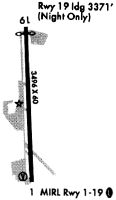
Runways
Runway Summary
| Runways: | 01/19 |
| Longest Runway: | 01/19 is 3496 ft (1066 m) long |
| Runways with an Instrument Approach: |
N14 Airport Runway Details
| Runway 01/19 | 3496 ft x 75 ft (1066 m x 23 m) | |
| Runway Length Source: | 3RD PARTY SURVEY as of 09/25/2008 | |
| Surface: | Asphalt - Fair condition - No special surface treatment | |
| Runway Edge Lights: | Medium Intensity | |
Runway 01 |
Runway 19 |
|
Elevation: |
35.0 | 49.1 |
Latitude: |
39-55-46.1733N | 39-56-20.6942N |
Longitude: |
074-48-25.0494W | 074-48-26.8516W |
|
Runway True Alignment: |
358 | 178 |
Glide Path Angle: |
3.5 degrees | 3.2 degrees |
Traffic Pattern: |
Right | |
Runway Markings Type: |
Nonprecision Instrument | Nonprecision Instrument |
Runway Markings Condition: |
Good | Good |
Object at End: |
TREES | |
Object Height: |
89 | |
Distance from End: |
262 | |
Object Centerline Offset: |
169 ft. right of centerline | |
Visual Glide Slope Indicators: |
2-Light PAPI On Left Side Of Runway | 2-Light PAPI On Left Side Of Runway |
REIL: |
Yes | Yes |
Threshold Crossing Height: |
26 | 22 |
Services
Airframe Repair: |
Major |
Powerplant Repair: |
Major |
Bottled Oxygen: |
None |
Bulk Oxygen: |
None |
Fuel Available: |
100LL |
Landing Fees: |
No |
Parking: |
Tiedowns available |
Maps & Diagrams
N14 Sectional
Flight Planning
at skyvector.com
at skyvector.com