Location
Latitude: |
63-43-57.3540N (63.732598) |
Longitude: |
148-54-38.2980W (-148.910638) |
Elevation: |
1720.0 feet MSL (524 m MSL) |
Magnetic Variation: |
15.2 E (as of April 2024 from WMM2020 model) |
Time Zone: |
UTC -9.0 (Standard Time) UTC -8.0 (Daylight Savings Time) |
From City: |
02 N.M. NE of Mckinley Park, Alaska |
Found On: |
Anchorage Chart |
FAA Region: |
AAL |
Contacts
Manager: |
Publicly owned: |
| SUPERINTENDENT, DENALI NAT. PARK PO BOX 9 DENALI NATL PARK, AK 99755 907-683-9581 |
NPS DENALI NATL PARK PO BOX 9 DENALI NATL PARK, AK 99755 907-683-2294 |
Operations
Airport Status: |
Operational |
Facility Use: |
Public |
Type: |
Airport |
Control tower: |
No |
Attendance (Months/Days/Hours): |
Months/Days/Hours Unattended |
Boundary ARTCC: |
ZAN (Anchorage) |
Responsible ARTCC: |
ZAN (Anchorage) |
Segmented Circle Indicator: |
No |
Traffic Pattern Altitude (MSL): |
2720 feet (829 m) |
NOTAMs Facility: |
INR |
NOTAM-D Service: |
Yes |
International Airport of Entry: |
No |
Customs Landing Rights: |
No |
Military Landing Rights: |
Yes |
Civil/Military Joint Use: |
No |
Based Aircraft
| Single Engine: | 4 |
| Multi Engine: | 2 |
| GA Helicopters: | 1 |
Annual Operations (as of 12/31/2019)
| Total Operations: | 3200 | |
| Air Taxi: | 1000 | 31.2% |
| GA Local: | 500 | 15.6% |
| GA Itinerant: | 1700 | 53.1% |
Communications
| CTAF: | 122.900 |
| AWOS-3P: | 135.75 (907-683-1673) |
Fixed Based Operators (FBOs) & Fuel
(Click on a business for detail)
Please help us keep this information up to date. This is a FREE SERVICE just like everything else on Airport Guide! If you see that a business needs to be added, modified, or deleted please fill out our Update Form.
To add, modify, or delete a business click here.
Please help us keep this information up to date. This is a FREE SERVICE just like everything else on Airport Guide! If you see that a business needs to be added, modified, or deleted please fill out our Update Form.
Area Code: 907 |
| Business Name | Frequency | Phone | Fuel Grade |
|---|
Flight Service Stations
| Primary | Alternate | |
| FSS on Field: | N | |
| FSS Name (ID): | Fairbanks(FAI) | |
| Frequency: | ||
| Toll Free Phone: | 1-866-248-6516 |
Instrument Procedures / Charts
Terminal Procedures are only available for airports in several countries with more being added all the time. If you are looking for a specific country's charts, please send an email to support(at)airportguide.com stating the country name. This will be used to prioritize the implementation.
Navigation Aids (Navaids) near MCL
| Dist (NM) | ID | Morse Code | Name | Type | Freq | True Hdg | Mag Hdg |
|---|---|---|---|---|---|---|---|
| 26.0 | UMM | . . _ _ _ _ _ | Summit | NDB | 326 | 193 | 178 |
| 49.0 | ICW | . . _ . _ . . _ _ | Ice Pool | NDB | 525 | 354 | 339 |
| 51.6 | ENN | . _ . _ . | Nenana | VORTAC | 115.80 | 355 | 340 |
| 68.2 | FAI | . . _ . . _ . . | Fairbanks | VORTAC | 108.60 | 19 | 4 |
| 72.8 | EIL | . . . . _ . . | Eielson | TACAN | 115.10 | 39 | 23 |
| 75.9 | CUN | _ . _ . . . _ _ . | Chena | NDB | 257 | 28 | 13 |
| 81.8 | FOX | . . _ . _ _ _ _ . . _ | Fox | NDB | 356 | 24 | 9 |
| 85.9 | BIG | _ . . . . . _ _ . | Big Delta | VORTAC | 114.90 | 77 | 61 |
| 86.9 | DJN | _ . . . _ _ _ _ . | Delta Junction | NDB | 347 | 76 | 60 |
| 90.1 | PEE | . _ _ . . . | Peters Creek | NDB | 305 | 201 | 186 |
| 90.6 | MHM | _ _ . . . . _ _ | Minchumina | NDB | 227 | 277 | 262 |
| 92.0 | TKA | _ _ . _ . _ | Talkeetna | VOR-DME | 116.20 | 201 | 186 |
Nearby Airports with Fuel
| Dist (NM) | Name (Airport IDs) | True Hdg | Mag Hdg | Fuel Grade |
|---|---|---|---|---|
| 20.5 | Cantwell Airport (PATW TTW) |
183 | 168 | 100LL |
| 49.1 | Nenana Municipal Airport (ENN PANN ENN) |
355 | 340 | 100LL, Jet A |
| 70.5 | Fairbanks International Airport (FAI PAFA FAI) |
22 | 6 | 100LL, Jet A-1 |
| 73.3 | Bradley Sky-Ranch Airport (95Z) |
32 | 16 | 100LL |
| 90.6 | Talkeetna Airport (TKA PATK TKA) |
201 | 186 | 100LL, Jet A, Jet A+ |
Notices to Airmen (NOTAMS)
Remarks
| A110-10 | NO OVERRUN AT EITHER RWY END. |
| A110-11 | WX CAMERA AVBL ON INTERNET AT HTTPS://WEATHERCAMS.FAA.GOV |
| A110-12 | PVT ROTORWING USE PROHIBITED, EXCP IN CASE OF EMERGS. |
| A110-3 | CANYON S & W OF ARPT SUBJECT TO STRONG DOWNDRAFTS. |
| A110-4 | COMMERCIAL OR BUSINESS USE OF THIS AIRSTRIP IS PROHIBITED EXCEPT UNDER PERMIT WITH THE NATIONAL PARK SERVICE. |
| A110-5 | RWY-34 MTN LCTD AT 10,500 FT FROM RY END. |
| A110-6 | FREQUENT PEDESTRIAN & WILDLIFE TFC ON RY. |
| A110-7 | ALL TRAFFIC PATTERNS TO EAST SIDE DUE TO TERRAIN CLEARANCE. |
| A110-9 | FREQS 122.725 NORTH/ 123.65 SOUTH IS DESIGNATED FOR INTER ACFT COMMUNICATION IN DENALI NATIONAL PARK. |
| A32-16/34 | ACFT PARKING ALONG SIDES OF RY 16/34 HAS REDUCED USABLE WIDTH TO 68 FT. |
| A33-16/34 | GRASS ENCROACHMENT ON BOTH SIDES OF RY. |
| A42-16 | RY 16/34 MARKED WITH DAMAGED AND FADED CONES. |
Runways
Runway Summary
| Runways: | 16/34 |
| Longest Runway: | 16/34 is 3000 ft (914 m) long |
| Runways with an Instrument Approach: |
MCL Airport Runway Details
| Runway 16/34 | 3000 ft x 68 ft (914 m x 21 m) | |
| Surface: | Gravel - Good condition - No special surface treatment | |
Runway 16 |
Runway 34 |
|
Glide Path Angle: |
0.0 degrees | 0.0 degrees |
Traffic Pattern: |
Left | Right |
Object at End: |
TREES | TREES |
Object Height: |
18 | 40 |
Distance from End: |
0 | 0 |
Object Centerline Offset: |
80 ft. left and right of centerline | 74 ft. left of centerline |
Services
Airframe Repair: |
Major |
Powerplant Repair: |
Major |
Bottled Oxygen: |
None |
Bulk Oxygen: |
None |
Fuel Available: |
100LL, Jet A, Jet A+ |
Landing Fees: |
No |
Parking: |
Tiedowns available |
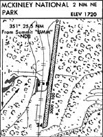
Maps & Diagrams
MCL Sectional
Flight Planning
at skyvector.com
at skyvector.com