Location
Latitude: |
39-00-40.0000N (39.011111) |
Longitude: |
095-12-59.3000W (-95.216472) |
Elevation: |
833.3 feet MSL (254 m MSL) |
Magnetic Variation: |
1.6 E (as of April 2024 from WMM2020 model) |
Time Zone: |
UTC -6.0 (Standard Time) UTC -5.0 (Daylight Savings Time) |
From City: |
03 N.M. N of Lawrence, Kansas |
Found On: |
Kansas City Chart |
FAA Region: |
ACE |
Contacts
Manager: |
Publicly owned: |
| SCOTT WAGNER 6 EAST 6TH STREET LAWRENCE, KS 66044 785-832-3467 |
CITY OF LAWRENCE PO BOX 708 LAWRENCE, KS 66044 785-832-3467 |
Operations
Airport Status: |
Operational |
Facility Use: |
Public |
Type: |
Airport |
Activation Date: |
04/1940 |
Control tower: |
No |
Attendance (Months/Days/Hours): |
Months/Days/Hours ALL/ALL/0800-2000 |
Boundary ARTCC: |
ZKC (Kansas City) |
Responsible ARTCC: |
ZKC (Kansas City) |
Lighting Schedule: |
SEE RMK |
Segmented Circle Indicator: |
Yes |
Traffic Pattern Altitude (MSL): |
1833 feet (559 m) |
NOTAMs Facility: |
LWC |
NOTAM-D Service: |
Yes |
International Airport of Entry: |
No |
Customs Landing Rights: |
No |
Military Landing Rights: |
Yes |
Civil/Military Joint Use: |
No |
Based Aircraft
| Single Engine: | 33 |
| Multi Engine: | 4 |
| Jet Engine: | 4 |
| GA Helicopters: | 23 |
Annual Operations (as of 08/31/2021)
| Total Operations: | 27408 | |
| Air Taxi: | 1400 | 5.1% |
| GA Local: | 13300 | 48.5% |
| GA Itinerant: | 12500 | 45.6% |
| Military Aircraft: | 208 | 0.8% |
Communications
| CTAF: | 123.000 |
| Unicom: | 123.000 |
| ASOS: | 121.225 (785-749-1309) |
- RADAR COVERAGE DOWN TO 600'.
- APCH/DEP CTL SVC PRVDD BY KANSAS CITY ARTCC (ZKC) ON FREQS 123.8/343.7 (TOPEKA RCAG).
- A/G COMMUNICATIONS FOR DEPARTURE CTL AVAILABLE ABOVE 500'.
- CD PRVDD BY KANSAS CITY ARTCC ON FREQ 121.825.
Fixed Based Operators (FBOs) & Fuel
(Click on a business for detail)
Please help us keep this information up to date. This is a FREE SERVICE just like everything else on Airport Guide! If you see that a business needs to be added, modified, or deleted please fill out our Update Form.
To add, modify, or delete a business click here.
Please help us keep this information up to date. This is a FREE SERVICE just like everything else on Airport Guide! If you see that a business needs to be added, modified, or deleted please fill out our Update Form.
Area Code: 785 |
| Business Name | Frequency | Phone | Fuel Grade |
|---|---|---|---|
| Hetrick Aircraft, Inc.
Update FBO info |
Unicom 123.0 | 842-0000 | 100LL, Jet A |
Flight Service Stations
| Primary | Alternate | |
| FSS on Field: | N | |
| FSS Name (ID): | Wichita(ICT) | |
| Frequency: | ||
| Toll Free Phone: | 1-800-WX-BRIEF |
Instrument Procedures / Charts
FAA Terminal Procedures valid from 0901Z 03/21/24 to 0901Z 04/18/24.
There are various types of charts available for an airport. They are listed in the Page Type column. Here is a legend for those types:
APD - Airport Diagram
DP - Departure Procedure Charts
HOT - Hot Spots
IAP - Instrument Approach Procedure Charts
MIN - Minimums
STAR - Standard Terminal Arrival Charts
| Page Type | Page Name | Volume | Action Since Last Cycle |
|---|---|---|---|
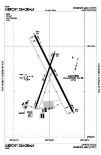
| APD | AIRPORT DIAGRAM | NC-2 | |
| IAP | ILS OR LOC RWY 33 | NC-2 | |
| IAP | RNAV (GPS) RWY 15 | NC-2 | |
| IAP | RNAV (GPS) RWY 33 | NC-2 | |
| IAP | VOR/DME-A | NC-2 | |
| MIN | ALTERNATE MINIMUMS | NC-2 | |
| MIN | TAKEOFF MINIMUMS | NC-2 |
Terminal Procedures are only available for airports in several countries with more being added all the time. If you are looking for a specific country's charts, please send an email to support(at)airportguide.com stating the country name. This will be used to prioritize the implementation.
Navigation Aids (Navaids) near LWC
| Dist (NM) | ID | Morse Code | Name | Type | Freq | True Hdg | Mag Hdg |
|---|---|---|---|---|---|---|---|
| 6.5 | JZ | . _ _ _ _ _ . . | Newbn | NDB | 338 | 153 | 151 |
| 17.2 | TOP | _ _ _ _ . _ _ . | Topeka | VORTAC | 117.80 | 296 | 294 |
| 18.6 | FO | . . _ . _ _ _ | Riply | NDB | 326 | 246 | 244 |
| 21.1 | FOE | . . _ . _ _ _ . | Forbes | TACAN | 111.60 | 259 | 257 |
| 21.3 | FOE | . . _ . _ _ _ . | Forbes | VOT | 111.00 | 260 | 258 |
| 22.9 | TO | _ _ _ _ | Biloy | NDB | 521 | 286 | 284 |
| 24.6 | OJC | _ _ _ . _ _ _ _ . _ . | Johnson County | VOR-DME | 113.00 | 114 | 113 |
| 25.1 | DO | _ . . _ _ _ | Dotte | NDB | 359 | 59 | 58 |
| 26.3 | GQ | _ _ . _ _ . _ | Norge | NDB | 517 | 83 | 82 |
| 27.2 | PK | . _ _ . _ . _ | Herbb | NDB | 420 | 124 | 123 |
| 27.7 | MCI | _ _ _ . _ . . . | Kansas City | VORTAC | 113.25 | 53 | 52 |
| 29.6 | MKC | _ _ _ . _ _ . _ . | Kansas City Downtown | VOT | 108.60 | 76 | 75 |
| 29.6 | RIS | . _ . . . . . . | Riverside | VOR-DME | 111.40 | 77 | 76 |
| 42.4 | ST | . . . _ | Tario | NDB | 260 | 19 | 18 |
| 48.8 | UKL | . . _ _ . _ . _ . . | Boyd | NDB | 245 | 209 | 207 |
| 50.9 | ANX | . _ _ . _ . . _ | Napoleon | VORTAC | 114.00 | 83 | 82 |
| 51.3 | RBA | . _ . _ . . . . _ | Robinson | DME | 108.2 | 349 | 347 |
| 54.3 | AZN | . _ _ _ . . _ . | Amazon | NDB | 233 | 15 | 14 |
| 56.0 | BUM | _ . . . . . _ _ _ | Butler | VORTAC | 115.90 | 142 | 141 |
| 58.5 | STJ | . . . _ . _ _ _ | St Joseph | VORTAC | 115.50 | 13 | 12 |
Nearby Airports with Fuel
Notices to Airmen (NOTAMS)
Remarks
| A16 | AFT HRS APRT MGR CTC - 785-813-5765 |
| A70-FUEL-10 | 0LL AFT HRS FUEL CTC - 785-865-6500. |
| A81-APT | ACTVT MALSR RWY 33; REIL RWY 01, 15, & 19; PAPI RWY 01, 19, 15 & 33; MIRL RWY 01/19 & 15/33 - CTAF. |
Runways
Runway Summary
| Runways: | 01/19 15/33 |
| Longest Runway: | 15/33 is 5700 ft (1737 m) long |
| Runways with an Instrument Approach: | 33 |
LWC Airport Runway Details
| Runway 01/19 | 3901 ft x 75 ft (1189 m x 23 m) | |
| Runway Length Source: | 3RD PARTY SURVEY as of 08/28/2010 | |
| Surface: | Concrete - Good condition - No special surface treatment | |
| Runway Pavement Class: | 4 /R/D/Y/U | |
| Runway Edge Lights: | Medium Intensity | |
Runway Weight Bearing Capacity (in thousands of pounds) |
||
| Single Wheel Landing Gear: | 12.5 | |
| Dual Wheel Landing Gear: | 15.6 | |
Runway 01 |
Runway 19 |
|
Elevation: |
832.5 | 831.0 |
Latitude: |
39-00-19.0108N | 39-00-55.4275N |
Longitude: |
095-13-11.8792W | 095-12-55.6484W |
|
Runway True Alignment: |
019 | 199 |
Glide Path Angle: |
3.5 degrees | 3.5 degrees |
Traffic Pattern: |
Left | Left |
Runway Markings Type: |
Nonprecision Instrument | Nonprecision Instrument |
Runway Markings Condition: |
Fair | Fair |
Visual Glide Slope Indicators: |
2-Light PAPI On Left Side Of Runway | 2-Light PAPI On Left Side Of Runway |
REIL: |
Yes | Yes |
Threshold Crossing Height: |
40 | 40 |
| Runway 15/33 | 5700 ft x 100 ft (1737 m x 30 m) | |
| Runway Length Source: | 3RD PARTY SURVEY as of 08/28/2010 | |
| Surface: | Concrete - Good condition - No special surface treatment | |
| Runway Pavement Class: | 16 /F/C/Y/U | |
| Runway Edge Lights: | Medium Intensity | |
Runway Weight Bearing Capacity (in thousands of pounds) |
||
| Single Wheel Landing Gear: | 40.0 | |
| Dual Wheel Landing Gear: | 60.0 | |
Runway 15 |
Runway 33 |
|
Elevation: |
831.1 | 827.2 |
Latitude: |
39-01-07.1701N | 39-00-16.7667N |
Longitude: |
095-13-12.3232W | 095-12-40.0710W |
|
Runway True Alignment: |
153 | 333 |
ILS Type: |
ILS | |
Glide Path Angle: |
3.0 degrees | 3.0 degrees |
Runway Markings Type: |
Nonprecision Instrument | Precision Instrument |
Runway Markings Condition: |
Good | Good |
Object at End: |
TREES | |
Object Height: |
49 | |
Distance from End: |
2462 | |
Visual Glide Slope Indicators: |
4-Light PAPI On Left Side Of Runway | 4-Light PAPI On Right Side Of Runway |
Approach Light System: |
1,400 Foot Medium Intensity Approach Lighting System With Runway Alignment Indicator Lights | |
REIL: |
Yes | |
Threshold Crossing Height: |
45 | 52 |
Services
Airframe Repair: |
Major |
Powerplant Repair: |
Major |
Bottled Oxygen: |
None |
Bulk Oxygen: |
None |
Fuel Available: |
100LL, Jet A |
Parking: |
Hangars and tiedowns available |
Maps & Diagrams
LWC Sectional
Flight Planning
at skyvector.com
at skyvector.com