Location
Latitude: |
41-47-30.3740N (41.791771) |
Longitude: |
111-51-05.9300W (-111.851647) |
Elevation: |
4456.9 feet MSL (1358 m MSL) |
Magnetic Variation: |
11 E (as of April 2024 from WMM2020 model) |
Time Zone: |
UTC -7.0 (Standard Time) UTC -6.0 (Daylight Savings Time) |
From City: |
03 N.M. NW of Logan, Utah |
Found On: |
Salt Lake City Chart |
FAA Region: |
ANM |
Contacts
Manager: |
Publicly owned: |
| JASON RIRIE 199 N. MAIN LOGAN, UT 84321 (435) 752-8111 |
LOGAN CITY & CACHE CO 199 N. MAIN LOGAN, UT 84321 (435) 755-1850 |
Operations
Airport Status: |
Operational |
Facility Use: |
Public |
Type: |
Airport |
Activation Date: |
11/1937 |
Control tower: |
No |
Attendance (Months/Days/Hours): |
Months/Days/Hours ALL/ALL/0800-1900 |
Boundary ARTCC: |
ZLC (Salt Lake City) |
Responsible ARTCC: |
ZLC (Salt Lake City) |
Lighting Schedule: |
SEE RMK |
Segmented Circle Indicator: |
Yes |
Traffic Pattern Altitude (MSL): |
5457 feet (1663 m) |
NOTAMs Facility: |
LGU |
NOTAM-D Service: |
Yes |
International Airport of Entry: |
No |
Customs Landing Rights: |
No |
Military Landing Rights: |
Yes |
Civil/Military Joint Use: |
No |
Aircraft Rescue and Firefighting: |
Class IV ARFF Index: A Air Carrier Service: Not Scheduled Certification Date: 08/2008 |
Based Aircraft
| Single Engine: | 123 |
| Multi Engine: | 16 |
| Jet Engine: | 7 |
| GA Helicopters: | 9 |
| Gliders: | 3 |
Annual Operations (as of 12/31/2021)
| Total Operations: | 135818 | |
| Commercial: | 38 | 0.0% |
| Air Taxi: | 1210 | 0.9% |
| GA Local: | 130640 | 96.2% |
| GA Itinerant: | 3880 | 2.9% |
| Military Aircraft: | 50 | 0.0% |
Communications
| CTAF: | 122.800 |
| Unicom: | 122.800 |
| ASOS: | 135.275 (435-752-6941) |
- COMMUNICATIONS PRVDD BY CEDAR CITY RADIO ON FREQ 122.2. (FRANCIS PEAK RCO)
- APCH/DEP CTL SVC PRVDD BY SALT LAKE ARTCC (ZLC) ON 127.7/354.125 (MALAD CITY RCAG).
Fixed Based Operators (FBOs) & Fuel
(Click on a business for detail)
Please help us keep this information up to date. This is a FREE SERVICE just like everything else on Airport Guide! If you see that a business needs to be added, modified, or deleted please fill out our Update Form.
To add, modify, or delete a business click here.
Please help us keep this information up to date. This is a FREE SERVICE just like everything else on Airport Guide! If you see that a business needs to be added, modified, or deleted please fill out our Update Form.
Area Code: 435 |
| Business Name | Frequency | Phone | Fuel Grade |
|---|---|---|---|
| Great Western Aviation
Website Update FBO info |
Unicom 122.8 | 752-5955, after hours call 752-0873, 770-0193 | 100LL, Jet A |
Flight Service Stations
| Primary | Alternate | |
| FSS on Field: | N | |
| FSS Name (ID): | Cedar City(CDC) | |
| Frequency: | ||
| Toll Free Phone: | 1-800-WX-BRIEF |
Instrument Procedures / Charts
FAA Terminal Procedures valid from 0901Z 03/21/24 to 0901Z 04/18/24.
There are various types of charts available for an airport. They are listed in the Page Type column. Here is a legend for those types:
APD - Airport Diagram
DP - Departure Procedure Charts
HOT - Hot Spots
IAP - Instrument Approach Procedure Charts
MIN - Minimums
STAR - Standard Terminal Arrival Charts
| Page Type | Page Name | Volume | Action Since Last Cycle |
|---|---|---|---|
| APD | AIRPORT DIAGRAM | SW-4 | |
| IAP | ILS OR LOC/DME RWY 17 | SW-4 | |
| IAP | RNAV (GPS) RWY 17 | SW-4 | |
| IAP | RNAV (GPS) RWY 35 | SW-4 | |
| MIN | ALTERNATE MINIMUMS | SW-4 | |
| MIN | TAKEOFF MINIMUMS | SW-4 | |
| ODP | ORNEY ONE (OBSTACLE) | SW-4 |
Terminal Procedures are only available for airports in several countries with more being added all the time. If you are looking for a specific country's charts, please send an email to support(at)airportguide.com stating the country name. This will be used to prioritize the implementation.
Navigation Aids (Navaids) near LGU
| Dist (NM) | ID | Morse Code | Name | Type | Freq | True Hdg | Mag Hdg |
|---|---|---|---|---|---|---|---|
| 7.1 | LHO | . _ . . . . . . _ _ _ | Brigham City | VOR-DME | 112.90 | 270 | 259 |
| 19.4 | BMC | _ . . . _ _ _ . _ . | Brigham City | NDB | 294 | 211 | 200 |
| 35.8 | OGD | _ _ _ _ _ . _ . . | Ogden | VORTAC | 115.70 | 198 | 187 |
| 36.3 | MLD | _ _ . _ . . _ . . | Malad City | VOR-DME | 117.40 | 312 | 301 |
| 40.6 | HIF | . . . . . . . . _ . | Hill | TACAN | 111.20 | 187 | 176 |
| 47.7 | EVW | . . . . _ . _ _ | Evanston | VOR-DME | 109.60 | 130 | 119 |
| 56.8 | TCH | _ _ . _ . . . . . | Wasatch | VORTAC | 116.80 | 185 | 174 |
| 61.7 | SLC | . . . . _ . . _ . _ . | Salt Lake City | VOT | 111.00 | 184 | 173 |
| 68.7 | FBR | . . _ . _ . . . . _ . | Fort Bridger | VOR-DME | 114.45 | 110 | 99 |
| 73.8 | PIH | . _ _ . . . . . . . | Pocatello | VOR-DME | 112.60 | 331 | 320 |
| 74.3 | TVY | _ . . . _ _ . _ _ | Tooele | NDB | 371 | 197 | 186 |
| 76.2 | PI | . _ _ . . . | Tyhee | NDB | 383 | 337 | 326 |
| 90.7 | BPI | _ . . . . _ _ . . . | Big Piney | VOR-DME | 116.50 | 58 | 47 |
| 91.1 | FFU | . . _ . . . _ . . . _ | Fairfield | VORTAC | 116.60 | 182 | 171 |
| 92.9 | LCU | . _ . . _ . _ . . . _ | Lucin | VORTAC | 113.60 | 254 | 243 |
| 94.8 | PVU | . _ _ . . . . _ . . _ | Provo | VOR-DME | 108.40 | 176 | 165 |
| 99.4 | SWU | . . . . _ _ . . _ | Sweden | NDB | 350 | 352 | 341 |
Nearby Airports with Fuel
Notices to Airmen (NOTAMS)
Remarks
| A110-1 | BIRDS ON & INVOF ARPT SPRING & SUMMER. |
| A110-2 | COLD TEMPERATURE AIRPORT. ALTITUDE CORRECTION REQUIRED AT OR BELOW -15C. |
| A110-3 | FLT TRNG INVOF ARPT. |
| A110-4 | FOR CD CTC SALT LAKE ARTCC AT 801-320-2568. |
| A30-10/28 | DALGT USE ONLY. |
| A70-FUEL-10 | 0LL AVBL H24 WITH CREDIT CARD; AFT HR - 435-753-2221/435-752-5955. |
| A81-APT | ACTVT MALSR RWY 17; REIL RWY 35; PAPI RWY 17 & 35; HIRL RWY 17/35 - CTAF. |
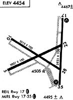
Runways
Runway Summary
| Runways: | 10/28 17/35 |
| Longest Runway: | 17/35 is 9020 ft (2749 m) long |
| Runways with an Instrument Approach: | 17 |
LGU Airport Runway Details
| Runway 10/28 | 4075 ft x 60 ft (1242 m x 18 m) | |
| Runway Length Source: | 3RD PARTY SURVEY as of 06/20/2021 | |
| Surface: | Asphalt - Excellent condition - No special surface treatment | |
Runway Weight Bearing Capacity (in thousands of pounds) |
||
| Single Wheel Landing Gear: | 12.0 | |
Runway 10 |
Runway 28 |
|
Elevation: |
4440.1 | 4449.7 |
Latitude: |
41-47-27.4548N | 41-47-05.9670N |
Longitude: |
111-51-54.3444W | 111-51-08.8700W |
|
Runway True Alignment: |
122 | 302 |
Glide Path Angle: |
0.0 degrees | 0.0 degrees |
Traffic Pattern: |
Left | Left |
Runway Markings Type: |
Basic | Basic |
Runway Markings Condition: |
Poor | Poor |
Object at End: |
RR | |
Object Height: |
23 | |
Distance from End: |
485 | |
Declared Distances |
||
Take Off Run Avbl. (TORA): |
4075 | 4075 |
Take Off Distance Avbl. (TODA): |
4075 | 4075 |
| Runway 17/35 | 9020 ft x 100 ft (2749 m x 30 m) | |
| Runway Length Source: | 3RD PARTY SURVEY as of 06/20/2021 | |
| Surface: | Asphalt - Excellent condition - No special surface treatment | |
| Runway Pavement Class: | 55 /F/D/X/T | |
| Runway Edge Lights: | High Intensity | |
Runway Weight Bearing Capacity (in thousands of pounds) |
||
| Single Wheel Landing Gear: | 24.0 | |
| Dual Wheel Landing Gear: | 179.0 | |
Runway 17 |
Runway 35 |
|
Elevation: |
4456.8 | 4456.4 |
Latitude: |
41-48-21.0418N | 41-46-52.0510N |
Longitude: |
111-50-51.5049W | 111-50-57.1513W |
|
Runway True Alignment: |
183 | 003 |
ILS Type: |
ILS/DME | |
Glide Path Angle: |
3.0 degrees | 3.0 degrees |
Traffic Pattern: |
Left | Left |
Runway Markings Type: |
Precision Instrument | Precision Instrument |
Runway Markings Condition: |
Good | Good |
Object at End: |
RR | |
Object Height: |
23 | |
Distance from End: |
555 | |
Visual Glide Slope Indicators: |
2-Light PAPI On Left Side Of Runway | 2-Light PAPI On Left Side Of Runway |
Approach Light System: |
1,400 Foot Medium Intensity Approach Lighting System With Runway Alignment Indicator Lights | |
REIL: |
No | Yes |
Threshold Crossing Height: |
45 | 39 |
Declared Distances |
||
Take Off Run Avbl. (TORA): |
9020 | 9020 |
Take Off Distance Avbl. (TODA): |
9020 | 9020 |
Actual Stop Dist. Avbl. (ASDA): |
9020 | 9020 |
Landing Dist. Avbl. (LDA): |
9020 | 9020 |
Services
Airframe Repair: |
None |
Powerplant Repair: |
None |
Bottled Oxygen: |
None |
Bulk Oxygen: |
None |
Fuel Available: |
100LL, Jet A |
Landing Fees: |
No |
Parking: |
Hangars and tiedowns available |
Maps & Diagrams
LGU Sectional
Flight Planning
at skyvector.com
at skyvector.com