Location
Latitude: |
33-35-13.5620N (33.587101) |
Longitude: |
080-12-31.2120W (-80.20867) |
Elevation: |
102.7 feet MSL (31 m MSL) |
Magnetic Variation: |
8.2 W (as of April 2024 from WMM2020 model) |
Time Zone: |
UTC -5.0 (Standard Time) UTC -4.0 (Daylight Savings Time) |
From City: |
07 N.M. S of Manning, South Carolina |
Found On: |
Charlotte Chart |
FAA Region: |
ASO |
Contacts
Manager: |
Publicly owned: |
| MS. VICKIE WILLIAMS 8606 HIGHWAY 260 MANNING, SC 29102 803-433-4004 |
CLARENDON COUNTY PO BOX 486 MANNING, SC 29102 803-435-8424 |
Operations
Airport Status: |
Operational |
Facility Use: |
Public |
Type: |
Airport |
Activation Date: |
09/1966 |
Control tower: |
No |
Attendance (Months/Days/Hours): |
Months/Days/Hours ALL/MON-FRI/0800-1700 |
Boundary ARTCC: |
ZJX (Jacksonville) |
Responsible ARTCC: |
ZJX (Jacksonville) |
Lighting Schedule: |
SEE RMK |
Segmented Circle Indicator: |
Yes |
Traffic Pattern Altitude (MSL): |
1103 feet (336 m) |
NOTAMs Facility: |
AND |
NOTAM-D Service: |
Yes |
International Airport of Entry: |
No |
Customs Landing Rights: |
No |
Military Landing Rights: |
Yes |
Civil/Military Joint Use: |
No |
Based Aircraft
| Single Engine: | 9 |
| Multi Engine: | 3 |
Annual Operations (as of 01/26/2023)
| Total Operations: | 5050 | |
| Air Taxi: | 202 | 4.0% |
| GA Local: | 2828 | 56.0% |
| GA Itinerant: | 1970 | 39.0% |
| Military Aircraft: | 50 | 1.0% |
Communications
| CTAF: | 122.800 |
| Unicom: | 122.800 |
| Approach: | SHAW 125.4 125.4 JAX ARTCC |
| Departure: | SHAW 125.4 125.4 JAX ARTCC |
| AWOS-3: | 120.175 (803-478-6060) |
- APCH/DEP SVC PRVDD BY JACKSONVILLE ARTCC ON FREQS 124.7/269.55 (COLUMBIA RCAG) WHEN SHAW APCH CTL CLSD.
Fixed Based Operators (FBOs) & Fuel
(Click on a business for detail)
Please help us keep this information up to date. This is a FREE SERVICE just like everything else on Airport Guide! If you see that a business needs to be added, modified, or deleted please fill out our Update Form.
To add, modify, or delete a business click here.
Please help us keep this information up to date. This is a FREE SERVICE just like everything else on Airport Guide! If you see that a business needs to be added, modified, or deleted please fill out our Update Form.
Area Code: 803 |
| Business Name | Frequency | Phone | Fuel Grade |
|---|---|---|---|
| Precision Air, Inc.
Update FBO info |
Unicom 122.8 | 478-4764 | 100LL |
Flight Service Stations
| Primary | Alternate | |
| FSS on Field: | N | |
| FSS Name (ID): | Anderson(AND) | |
| Frequency: | ||
| Toll Free Phone: | 1-800-WX-BRIEF |
Instrument Procedures / Charts
FAA Terminal Procedures valid from 0901Z 03/21/24 to 0901Z 04/18/24.
There are various types of charts available for an airport. They are listed in the Page Type column. Here is a legend for those types:
APD - Airport Diagram
DP - Departure Procedure Charts
HOT - Hot Spots
IAP - Instrument Approach Procedure Charts
MIN - Minimums
STAR - Standard Terminal Arrival Charts
| Page Type | Page Name | Volume | Action Since Last Cycle |
|---|---|---|---|
| IAP | NDB RWY 02 | SE-2 | |
| MIN | TAKEOFF MINIMUMS | SE-2 |
Terminal Procedures are only available for airports in several countries with more being added all the time. If you are looking for a specific country's charts, please send an email to support(at)airportguide.com stating the country name. This will be used to prioritize the implementation.
Navigation Aids (Navaids) near KMNI
| Dist (NM) | ID | Morse Code | Name | Type | Freq | True Hdg | Mag Hdg |
|---|---|---|---|---|---|---|---|
| 0.1 | MNI | _ _ _ . . . | Manning | NDB | 381 | 69 | 77 |
| 13.8 | VAN | . . . _ . _ _ . | Vance | VORTAC | 110.40 | 240 | 248 |
| 19.3 | CKI | _ . _ . _ . _ . . | Kingstree | NDB | 404 | 65 | 73 |
| 25.4 | SMS | . . . _ _ . . . | Sumter | NDB | 252 | 342 | 350 |
| 26.7 | SSC | . . . . . . _ . _ . | Shaw | TACAN | 110.10 | 331 | 339 |
| 27.3 | CFY | _ . _ . . . _ . _ . _ _ | Evans | NDB | 420 | 53 | 61 |
| 31.7 | DYB | _ . . _ . _ _ _ . . . | Dorchester County | NDB | 365 | 186 | 194 |
| 33.4 | EDS | . _ . . . . . | Edisto | VOR-DME | 111.40 | 256 | 264 |
| 35.0 | PHH | . _ _ . . . . . . . . . | Andrews | NDB | 255 | 103 | 111 |
| 35.2 | HEK | . . . . . _ . _ | Stuckey | NDB | 236 | 75 | 83 |
| 35.9 | MMT | _ _ _ _ _ | Mc Entire | VORTAC | 113.20 | 304 | 312 |
| 37.1 | CH | _ . _ . . . . . | Ashly | NDB | 329 | 171 | 179 |
| 39.4 | FL | . . _ . . _ . . | Alcot | NDB | 335 | 26 | 34 |
| 41.7 | CHS | _ . _ . . . . . . . . | Charleston | VOT | 111.00 | 168 | 176 |
| 42.4 | CHS | _ . _ . . . . . . . . | Charleston | VORTAC | 113.50 | 168 | 176 |
| 45.2 | CAE | _ . _ . . _ . | Columbia | VORTAC | 114.70 | 291 | 299 |
| 45.2 | RBW | . _ . _ . . . . _ _ | Walterboro | NDB | 221 | 208 | 216 |
| 47.2 | GGE | _ _ . _ _ . . | Georgetown | NDB | 242 | 109 | 117 |
| 47.5 | FLO | . . _ . . _ . . _ _ _ | Florence | VORTAC | 115.20 | 35 | 43 |
| 49.4 | HVS | . . . . . . . _ . . . | Hartsville | NDB | 341 | 5 | 13 |
Nearby Airports with Fuel
Notices to Airmen (NOTAMS)
Remarks
| A110-2 | GLIDER OPNS ON & INVOF ARPT. |
| A110-3 | FOR CD CTC SHAW APCH AT 803-895-4884, WHEN APCH CLSD CTC JACKSONVILLE ARTCC AT 904-845-1592. |
| A70-FUEL-10 | 0LL SELF SVC FUEL AVBL 24 HRS WITH CREDIT CARD. |
| A81-APT | MIRL PRESET LOW INTST DUSK-2300; TO INCR INTST - CTAF. TO ACTVT AFT 2300 - CTAF. |
Runways
Runway Summary
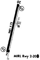
| Runways: | 02/20 |
| Longest Runway: | 02/20 is 3602 ft (1098 m) long |
| Runways with an Instrument Approach: |
KMNI Airport Runway Details
| Runway 02/20 | 3602 ft x 75 ft (1098 m x 23 m) | |
| Runway Length Source: | 3RD PARTY SURVEY as of 02/02/2019 | |
| Surface: | Asphalt - Good condition - No special surface treatment | |
| Runway Edge Lights: | Medium Intensity | |
Runway Weight Bearing Capacity (in thousands of pounds) |
||
| Single Wheel Landing Gear: | 30.0 | |
Runway 02 |
Runway 20 |
|
Elevation: |
94.4 | 102.7 |
Latitude: |
33-34-56.1438N | 33-35-30.9808N |
Longitude: |
080-12-35.6969W | 080-12-26.7264W |
|
Runway True Alignment: |
012 | 192 |
Glide Path Angle: |
4.0 degrees | 4.0 degrees |
Traffic Pattern: |
Left | Left |
Runway Markings Type: |
Nonprecision Instrument | Nonprecision Instrument |
Runway Markings Condition: |
Good | Good |
Object at End: |
TREE | TREE |
Object Height: |
47 | 61 |
Distance from End: |
1153 | 1471 |
Object Centerline Offset: |
230 ft. right of centerline | 93 ft. right of centerline |
Visual Glide Slope Indicators: |
2-Light PAPI On Left Side Of Runway | 2-Light PAPI On Left Side Of Runway |
REIL: |
No | No |
Touchdown Lights: |
No | No |
Centerline Lights: |
No | No |
Threshold Crossing Height: |
34 | 32 |
Services
Airframe Repair: |
Major |
Powerplant Repair: |
Major |
Bottled Oxygen: |
None |
Bulk Oxygen: |
None |
Fuel Available: |
100LL, Jet A, Jet A+ |
Landing Fees: |
No |
Parking: |
Tiedowns available |
Maps & Diagrams
KMNI Sectional
Flight Planning
at skyvector.com
at skyvector.com