Location
Latitude: |
35-51-43.8940N (35.862193) |
Longitude: |
077-10-41.5220W (-77.178201) |
Elevation: |
74.9 feet MSL (23 m MSL) |
Magnetic Variation: |
10.2 W (as of April 2024 from WMM2020 model) |
Time Zone: |
UTC -5.0 (Standard Time) UTC -4.0 (Daylight Savings Time) |
From City: |
06 N.M. W of Williamston, North Carolina |
Found On: |
Charlotte Chart |
FAA Region: |
ASO |
Contacts
Manager: |
Publicly owned: |
| JESSE COUNCIL, JULIET CHARLIE AVIAT 2135 AIRPORT RD WILLIAMSTON, NC 27892 252-792-1971 |
COUNTY OF MARTIN 305 E. MAIN STREET, PO BOX 668 WILLIAMSTON, NC 27892 252-789-4300 |
Operations
Airport Status: |
Operational |
Facility Use: |
Public |
Type: |
Airport |
Control tower: |
No |
Attendance (Months/Days/Hours): |
Months/Days/Hours ALL/ALL/0800-1700 |
Boundary ARTCC: |
ZDC (Washington) |
Responsible ARTCC: |
ZDC (Washington) |
Lighting Schedule: |
SEE RMK |
Segmented Circle Indicator: |
Yes |
Traffic Pattern Altitude (MSL): |
1075 feet (328 m) |
NOTAMs Facility: |
RDU |
NOTAM-D Service: |
Yes |
Military Landing Rights: |
Yes |
Civil/Military Joint Use: |
No |
Based Aircraft
| Single Engine: | 13 |
| GA Helicopters: | 2 |
Annual Operations (as of 05/30/2021)
| Total Operations: | 12500 | |
| GA Local: | 7000 | 56.0% |
| GA Itinerant: | 5000 | 40.0% |
| Military Aircraft: | 500 | 4.0% |
Communications
| CTAF: | 122.800 |
| Unicom: | 122.800 |
| AWOS-3P: | 118.65 (252-802-4261) |
- APCH/DEP SVC PRVDD BY WASHINGTON ARTCC (ZDC) ON 123.85/279.65 (NEW BERN RCAG).
Fixed Based Operators (FBOs) & Fuel
(Click on a business for detail)
Please help us keep this information up to date. This is a FREE SERVICE just like everything else on Airport Guide! If you see that a business needs to be added, modified, or deleted please fill out our Update Form.
To add, modify, or delete a business click here.
Please help us keep this information up to date. This is a FREE SERVICE just like everything else on Airport Guide! If you see that a business needs to be added, modified, or deleted please fill out our Update Form.
Area Code: 252 |
| Business Name | Frequency | Phone | Fuel Grade |
|---|
Flight Service Stations
| Primary | Alternate | |
| FSS on Field: | N | |
| FSS Name (ID): | Raleigh(RDU) | |
| Frequency: | ||
| Toll Free Phone: | 1-800-WX-BRIEF |
Instrument Procedures / Charts
FAA Terminal Procedures valid from 0901Z 03/21/24 to 0901Z 04/18/24.
There are various types of charts available for an airport. They are listed in the Page Type column. Here is a legend for those types:
APD - Airport Diagram
DP - Departure Procedure Charts
HOT - Hot Spots
IAP - Instrument Approach Procedure Charts
MIN - Minimums
STAR - Standard Terminal Arrival Charts
| Page Type | Page Name | Volume | Action Since Last Cycle |
|---|---|---|---|
| IAP | RNAV (GPS) RWY 03 | SE-2 | |
| IAP | RNAV (GPS) RWY 21 | SE-2 | |
| MIN | ALTERNATE MINIMUMS | SE-2 | |
| MIN | TAKEOFF MINIMUMS | SE-2 |
Terminal Procedures are only available for airports in several countries with more being added all the time. If you are looking for a specific country's charts, please send an email to support(at)airportguide.com stating the country name. This will be used to prioritize the implementation.
Navigation Aids (Navaids) near KMCZ
| Dist (NM) | ID | Morse Code | Name | Type | Freq | True Hdg | Mag Hdg |
|---|---|---|---|---|---|---|---|
| 0.2 | MCZ | _ _ _ . _ . _ _ . . | Williamston | NDB | 336 | 175 | 185 |
| 13.3 | AQE | . _ _ _ . _ . | Alwood | NDB | 230 | 225 | 235 |
| 16.6 | PGV | . _ _ . _ _ . . . . _ | Belvoir | FAN MARKER | 216 | 226 | |
| 18.4 | ETC | . _ _ . _ . | Tarboro | NDB | 257 | 283 | 293 |
| 21.4 | RNW | . _ . _ . . _ _ | Chocowinity | NDB | 388 | 170 | 180 |
| 26.4 | TYI | _ _ . _ _ . . | Tar River | VORTAC | 117.80 | 285 | 295 |
| 31.3 | EDE | . _ . . . | Edenton | NDB | 265 | 71 | 81 |
| 34.1 | CVI | _ . _ . . . . _ . . | Cofield | VORTAC | 114.60 | 25 | 35 |
| 34.8 | ISO | . . . . . _ _ _ | Kinston | VORTAC | 117.50 | 212 | 222 |
| 43.2 | RZZ | . _ . _ _ . . _ _ . . | Rapids | NDB | 407 | 323 | 333 |
| 45.0 | IS | . . . . . | Stals | NDB | 276 | 214 | 224 |
| 46.9 | ELQ | . . _ . . _ _ . _ | Emporia | NDB | 261 | 345 | 355 |
| 47.8 | EWN | . . _ _ _ . | New Bern | VOR-DME | 113.60 | 172 | 182 |
| 49.0 | LLW | . _ . . . _ . . . _ _ | Woodville | NDB | 254 | 60 | 70 |
| 50.0 | GSB | _ _ . . . . _ . . . | Seymour Johnson | TACAN | 116.50 | 230 | 240 |
| 50.7 | EW | . . _ _ | Katfi | NDB | 362 | 174 | 184 |
| 51.1 | RK | . _ . _ . _ | Waley | NDB | 249 | 29 | 39 |
| 51.7 | FKN | . . _ . _ . _ _ . | Franklin | VORTAC | 110.60 | 8 | 18 |
| 54.1 | ECG | . _ . _ . _ _ . | Elizabeth City | VOR-DME | 112.50 | 63 | 74 |
| 58.7 | EY | . _ . _ _ | Chesi | NDB | 233 | 40 | 50 |
Nearby Airports with Fuel
Notices to Airmen (NOTAMS)
Remarks
| A110-1 | DEER ON AND INVOF ARPT. |
| A110-2 | FOR CD CTC WASHINGTON ARTCC AT 703-771-3587. |
| A110-3 | RWY 03 HAS 10-15 FT DROP-OFF 70 FT FM CNTRLN BOTH SIDES. |
| A17 | FOR SVC AFT HRS CALL 252-799-8718 OR 252-217-4023. |
| A42-03 | RWY 03 MARKINGS FADED. |
| A42-21 | RWY 21 MARKINGS FADED. |
| A43-03 | OTS INDEF. |
| A70-FUEL-10 | 0LL 100LL AND JET-A HAS 24 HR SELF-SVC WITH CC. |
| A81-APT | PAPI RWY 03 & 21 OPR CONT. MIRL RWY 03/21 DUSK TO DAWN; TO CHG INTST - CTAF. |
Runways
Runway Summary
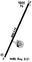
| Runways: | 03/21 |
| Longest Runway: | 03/21 is 5000 ft (1524 m) long |
| Runways with an Instrument Approach: |
KMCZ Airport Runway Details
| Runway 03/21 | 5000 ft x 75 ft (1524 m x 23 m) | |
| Runway Length Source: | 3RD PARTY SURVEY as of 04/13/2020 | |
| Surface: | Asphalt - Good condition - No special surface treatment | |
| Runway Edge Lights: | Medium Intensity | |
Runway Weight Bearing Capacity (in thousands of pounds) |
||
| Single Wheel Landing Gear: | 21.0 | |
Runway 03 |
Runway 21 |
|
Elevation: |
64.7 | 74.3 |
Latitude: |
35-51-21.2644N | 35-52-06.5241N |
Longitude: |
077-10-53.7478W | 077-10-29.2947W |
|
Runway True Alignment: |
024 | 204 |
Glide Path Angle: |
3.0 degrees | 3.0 degrees |
Traffic Pattern: |
Left | Left |
Runway Markings Type: |
Nonprecision Instrument | Nonprecision Instrument |
Runway Markings Condition: |
Poor | Poor |
Object at End: |
ROAD | ROAD |
Object Height: |
16 | 15 |
Distance from End: |
362 | 587 |
Object Centerline Offset: |
274 ft. right of centerline | 242 ft. left of centerline |
Visual Glide Slope Indicators: |
2-Light PAPI On Left Side Of Runway | 2-Light PAPI On Left Side Of Runway |
Threshold Crossing Height: |
35 | 24 |
Services
Airframe Repair: |
Major |
Powerplant Repair: |
Major |
Bottled Oxygen: |
None |
Bulk Oxygen: |
None |
Fuel Available: |
100LL, Jet A-1+ |
Landing Fees: |
No |
Parking: |
Tiedowns available |
Maps & Diagrams
KMCZ Sectional
Flight Planning
at skyvector.com
at skyvector.com