Location
Latitude: |
36-10-58.8786N (36.183022) |
Longitude: |
086-53-11.3832W (-86.886495) |
Elevation: |
501.0 feet MSL (153 m MSL) |
Magnetic Variation: |
4.1 W (as of April 2024 from WMM2020 model) |
Time Zone: |
UTC -6.0 (Standard Time) UTC -5.0 (Daylight Savings Time) |
From City: |
01 N.M. NW of Nashville, Tennessee |
Found On: |
St Louis Chart |
FAA Region: |
ASO |
Contacts
Manager: |
Publicly owned: |
| CHRISTOPHER B. DAVIDSON 110 TUNE AIRPORT DRIVE NASHVILLE, TN 37209 615-275-1783 |
METRO NASHVILLE APT AUTHORITY ONE TERMINAL DR. NASHVILLE, TN 37214 615-275-1600 |
Operations
Airport Status: |
Operational |
Facility Use: |
Public |
Type: |
Airport |
Activation Date: |
07/1986 |
Control tower: |
Yes |
Attendance (Months/Days/Hours): |
Months/Days/Hours ALL/ALL/ALL |
Boundary ARTCC: |
ZME (Memphis) |
Responsible ARTCC: |
ZME (Memphis) |
Lighting Schedule: |
SEE RMK |
Segmented Circle Indicator: |
Yes |
Traffic Pattern Altitude (MSL): |
1501 feet (458 m) |
NOTAMs Facility: |
BNA |
NOTAM-D Service: |
Yes |
Based Aircraft
| Single Engine: | 136 |
| Multi Engine: | 26 |
| Jet Engine: | 17 |
| GA Helicopters: | 11 |
Annual Operations (as of 08/03/2023)
| Total Operations: | 64000 | |
| Air Taxi: | 2500 | 3.9% |
| GA Local: | 26000 | 40.6% |
| GA Itinerant: | 35000 | 54.7% |
| Military Aircraft: | 500 | 0.8% |
Communications
| CTAF: | 119.450 |
| Unicom: | 122.700 |
| Tower: | JOHN TUNE 119.45 Hrs: 0600-2000 |
| Clearance Del.: | 121.7 |
| Ground: | 121.7 |
| Approach: | NASHVILLE 119.35 119.35 119.35 |
| Departure: | NASHVILLE 119.35 119.35 119.35 |
| ATIS: | 127.075 Hrs: 24 |
| AWOS-3: | (615-350-6222) |
Fixed Based Operators (FBOs) & Fuel
(Click on a business for detail)
Please help us keep this information up to date. This is a FREE SERVICE just like everything else on Airport Guide! If you see that a business needs to be added, modified, or deleted please fill out our Update Form.
To add, modify, or delete a business click here.
Please help us keep this information up to date. This is a FREE SERVICE just like everything else on Airport Guide! If you see that a business needs to be added, modified, or deleted please fill out our Update Form.
Area Code: 615 |
| Business Name | Frequency | Phone | Fuel Grade |
|---|---|---|---|
| Corporate Flight Management
Update FBO info |
Unicom 122.7 | 350-5000 | 100LL, Jet A |
Flight Service Stations
| Primary | Alternate | |
| FSS on Field: | ||
| FSS Name (ID): | Nashville(BNA) | |
| Frequency: | ||
| Toll Free Phone: | 1-800-WX-BRIEF |
Instrument Procedures / Charts
FAA Terminal Procedures valid from 0901Z 03/21/24 to 0901Z 04/18/24.
There are various types of charts available for an airport. They are listed in the Page Type column. Here is a legend for those types:
APD - Airport Diagram
DP - Departure Procedure Charts
HOT - Hot Spots
IAP - Instrument Approach Procedure Charts
MIN - Minimums
STAR - Standard Terminal Arrival Charts
| Page Type | Page Name | Volume | Action Since Last Cycle |
|---|---|---|---|
| APD | AIRPORT DIAGRAM | SE-1 | Changed |
| DP | JOHN TUNE ONE | SE-1 | |
| IAP | ILS OR LOC RWY 20 | SE-1 | Changed |
| IAP | RNAV (GPS) RWY 02 | SE-1 | Changed |
| IAP | RNAV (GPS) RWY 20 | SE-1 | Changed |
| MIN | TAKEOFF MINIMUMS | SE-1 |
Terminal Procedures are only available for airports in several countries with more being added all the time. If you are looking for a specific country's charts, please send an email to support(at)airportguide.com stating the country name. This will be used to prioritize the implementation.
Navigation Aids (Navaids) near KJWN
| Dist (NM) | ID | Morse Code | Name | Type | Freq | True Hdg | Mag Hdg |
|---|---|---|---|---|---|---|---|
| 10.2 | BNA | _ . . . _ . . _ | Nashville | VORTAC | 114.10 | 105 | 109 |
| 11.4 | VI | . . . _ . . | Opery | NDB | 344 | 83 | 87 |
| 11.7 | BNA | _ . . . _ . . _ | Nashville Metropoln | VOT | 108.60 | 110 | 114 |
| 17.3 | ON | _ _ _ _ . | Music | NDB | 279 | 344 | 348 |
| 21.2 | MQY | _ _ _ _ . _ _ . _ _ | Smyrna | VOT | 110.20 | 119 | 123 |
| 24.6 | SWZ | . . . . _ _ _ _ . . | Sewart | NDB | 391 | 123 | 127 |
| 26.7 | DMZ | _ . . _ _ _ _ . . | Dickson | NDB | 203 | 262 | 266 |
| 27.7 | JUE | . _ _ _ . . _ . | Lebanon | NDB | 414 | 88 | 92 |
| 28.3 | FQW | . . _ . _ _ . _ . _ _ | Walter Hill | NDB | 371 | 117 | 121 |
| 31.8 | CK | _ . _ . _ . _ | Snuff | NDB | 335 | 310 | 314 |
| 34.5 | GHM | _ _ . . . . . _ _ | Graham | DME | 111.6 | 232 | 236 |
| 35.9 | PBC | . _ _ . _ . . . _ . _ . | Maury County | NDB | 365 | 196 | 200 |
| 36.6 | CKV | _ . _ . _ . _ . . . _ | Clarksville | VOR-DME | 110.60 | 316 | 320 |
| 41.1 | LUG | . _ . . . . _ _ _ . | Verona | NDB | 251 | 174 | 178 |
| 41.5 | HXW | . . . . _ . . _ . _ _ | Screaming Eagle | TACAN | 114.90 | 313 | 317 |
| 41.6 | AEY | . _ . _ . _ _ | Waverly | NDB | 329 | 264 | 268 |
| 41.9 | FK | . . _ . _ . _ | Airbe | NDB | 273 | 322 | 326 |
| 43.1 | SYI | . . . _ . _ _ . . | Shelbyville | VOR-DME | 113.55 | 149 | 153 |
| 46.2 | BW | _ . . . . _ _ | Noora | NDB | 236 | 24 | 28 |
| 46.7 | SYI | . . . _ . _ _ . . | Bomar | FAN MARKER | 153 | 157 |
Nearby Airports with Fuel
Notices to Airmen (NOTAMS)
Remarks
| A110-1 | BIRDS & DEER INVOF ARPT. |
| A110-3 | BLEEDOVER OCR ALL FREQS 1.75 NM NORTH OF RWY. |
| A110-7 | WHEN ATCT CLSD FOR CD CTC NASHVILLE APCH ON 124.55, IF UNABLE CALL 615-695-4524. |
| A16 | 615-347-4196 |
| A30-02/20 | RWY 20 CALM WIND RWY. |
| A76 | HEL & FIXED WING. |
| A81-APT | WHEN ATCT CLSD ACTVT REIL RWY 02 & 20; PAPI RWY 02 & 20; MIRL RWY 02/20 - CTAF. |
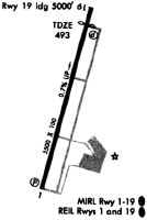
Runways
Runway Summary
| Runways: | 02/20 |
| Longest Runway: | 02/20 is 6001 ft (1829 m) long |
| Runways with an Instrument Approach: | 20 |
KJWN Airport Runway Details
| Runway 02/20 | 6001 ft x 100 ft (1829 m x 30 m) | |
| Runway Length Source: | 3RD PARTY SURVEY as of 08/08/2015 | |
| Surface: | Asphalt - Good condition - Saw-cut or plastic grooved | |
| Runway Edge Lights: | Medium Intensity | |
Runway Weight Bearing Capacity (in thousands of pounds) |
||
| Single Wheel Landing Gear: | 35.0 | |
| Dual Wheel Landing Gear: | 97.0 | |
Runway 02 |
Runway 20 |
|
Elevation: |
458.6 | 501.0 |
Latitude: |
36-10-30.1876N | 36-11-27.5668N |
Longitude: |
086-53-20.7097W | 086-53-02.0598W |
|
Runway True Alignment: |
015 | 195 |
ILS Type: |
ILS/DME | |
Glide Path Angle: |
3.0 degrees | 3.0 degrees |
Traffic Pattern: |
Right | |
Runway Markings Type: |
Nonprecision Instrument | Precision Instrument |
Runway Markings Condition: |
Good | Good |
Object at End: |
TREE | TREE |
Object Height: |
49 | 63 |
Distance from End: |
1545 | 2166 |
Object Centerline Offset: |
348 ft. right of centerline | 440 ft. right of centerline |
Visual Glide Slope Indicators: |
4-Light PAPI On Left Side Of Runway | 4-Light PAPI On Left Side Of Runway |
REIL: |
Yes | Yes |
Threshold Crossing Height: |
40 | 40 |
Declared Distances |
||
Take Off Run Avbl. (TORA): |
6001 | 6001 |
Take Off Distance Avbl. (TODA): |
6001 | 6001 |
Actual Stop Dist. Avbl. (ASDA): |
6001 | 6001 |
Landing Dist. Avbl. (LDA): |
6001 | 6001 |
Services
Airframe Repair: |
Major |
Powerplant Repair: |
Major |
Bottled Oxygen: |
None |
Bulk Oxygen: |
None |
Fuel Available: |
100LL, Jet A, Jet A+ |
Landing Fees: |
No |
Parking: |
Hangars and tiedowns available |
Maps & Diagrams
KJWN Sectional
Flight Planning
at skyvector.com
at skyvector.com