Location
Latitude: |
39-14-33.0400N (39.242511) |
Longitude: |
102-17-07.3590W (-102.285378) |
Elevation: |
4218.4 feet MSL (1286 m MSL) |
Magnetic Variation: |
6.1 E (as of April 2024 from WMM2020 model) |
Time Zone: |
UTC -7.0 (Standard Time) UTC -6.0 (Daylight Savings Time) |
From City: |
03 N.M. S of Burlington, Colorado |
Found On: |
Wichita Chart |
FAA Region: |
ANM |
Contacts
Manager: |
Publicly owned: |
| DANIEL MELIA 14111 HWY 385 BURLINGTON, CO 80807 719-346-5352 |
CITY OF BURLINGTON 415 15TH STREET BURLINGTON, CO 80807 719-346-8652 |
Operations
Airport Status: |
Operational |
Facility Use: |
Public |
Type: |
Airport |
Activation Date: |
06/1984 |
Control tower: |
No |
Attendance (Months/Days/Hours): |
Months/Days/Hours ALL/ALL/DALGT |
Boundary ARTCC: |
ZDV (Denver) |
Responsible ARTCC: |
ZDV (Denver) |
Lighting Schedule: |
SEE RMK |
Segmented Circle Indicator: |
Yes |
Traffic Pattern Altitude (MSL): |
5218 feet (1590 m) |
NOTAMs Facility: |
ITR |
NOTAM-D Service: |
Yes |
Military Landing Rights: |
Yes |
Based Aircraft
| Single Engine: | 20 |
Annual Operations (as of 12/31/2016)
| Total Operations: | 8000 | |
| GA Local: | 3200 | 40.0% |
| GA Itinerant: | 4713 | 58.9% |
| Military Aircraft: | 87 | 1.1% |
Communications
| CTAF: | 122.800 |
| Unicom: | 122.800 |
| ASOS: | 135.225 (719-346-7036) |
- APCH/DEP CTL SVC PRVDD BY DENVER ARTCC (ZDV) ON FREQS 132.7/226.675 (GOODLAND RCAG).
Fixed Based Operators (FBOs) & Fuel
(Click on a business for detail)
Please help us keep this information up to date. This is a FREE SERVICE just like everything else on Airport Guide! If you see that a business needs to be added, modified, or deleted please fill out our Update Form.
To add, modify, or delete a business click here.
Please help us keep this information up to date. This is a FREE SERVICE just like everything else on Airport Guide! If you see that a business needs to be added, modified, or deleted please fill out our Update Form.
Area Code: 719 |
| Business Name | Frequency | Phone | Fuel Grade |
|---|---|---|---|
| Burlington Aviation
Update FBO info |
Unicom 122.8 | 346-5352 | 100LL, Jet A |
Flight Service Stations
| Primary | Alternate | |
| FSS on Field: | N | |
| FSS Name (ID): | Denver(DEN) | |
| Frequency: | ||
| Toll Free Phone: | 1-800-WX-BRIEF |
Instrument Procedures / Charts
FAA Terminal Procedures valid from 0901Z 03/21/24 to 0901Z 04/18/24.
There are various types of charts available for an airport. They are listed in the Page Type column. Here is a legend for those types:
APD - Airport Diagram
DP - Departure Procedure Charts
HOT - Hot Spots
IAP - Instrument Approach Procedure Charts
MIN - Minimums
STAR - Standard Terminal Arrival Charts
| Page Type | Page Name | Volume | Action Since Last Cycle |
|---|---|---|---|
| IAP | LOC RWY 33 | SW-1 | Changed |
| IAP | NDB RWY 15 | SW-1 | Changed |
| IAP | RNAV (GPS) RWY 15 | SW-1 | Changed |
| IAP | RNAV (GPS) RWY 33 | SW-1 | Changed |
| MIN | ALTERNATE MINIMUMS | SW-1 | |
| MIN | TAKEOFF MINIMUMS | SW-1 |
Terminal Procedures are only available for airports in several countries with more being added all the time. If you are looking for a specific country's charts, please send an email to support(at)airportguide.com stating the country name. This will be used to prioritize the implementation.
Navigation Aids (Navaids) near KITR
| Dist (NM) | ID | Morse Code | Name | Type | Freq | True Hdg | Mag Hdg |
|---|---|---|---|---|---|---|---|
| 0.2 | ITR | . . _ . _ . | Kit Carson | NDB | 209 | 18 | 12 |
| 28.9 | GLD | _ _ . . _ . . _ . . | Goodland | VORTAC | 115.10 | 72 | 66 |
| 32.0 | GL | _ _ . . _ . . | Shugr | NDB | 414 | 84 | 78 |
| 37.8 | SYF | . . . _ . _ _ . . _ . | St Francis | NDB | 386 | 39 | 33 |
| 51.0 | TXC | _ _ . . _ _ . _ . | Thurman | VORTAC | 112.90 | 302 | 296 |
| 59.6 | JDM | . _ _ _ _ . . _ _ | Wheatfield | NDB | 408 | 73 | 67 |
| 65.5 | LAA | . _ . . . _ . _ | Lamar | VOR-DME | 116.90 | 196 | 190 |
| 67.3 | HGO | . . . . _ _ . _ _ _ | Hugo | VOR-DME | 112.10 | 248 | 242 |
| 68.6 | AKO | . _ _ . _ _ _ _ | Akron | VOR-DME | 114.40 | 323 | 317 |
| 68.8 | OEL | _ _ _ . . _ . . | Oakley | NDB | 380 | 96 | 90 |
| 79.7 | TQK | _ _ _ . _ _ . _ | Scott City | NDB | 256 | 124 | 118 |
| 88.2 | OIN | _ _ _ . . _ . | Oberlin | NDB | 341 | 65 | 59 |
| 88.8 | BAJ | _ . . . . _ . _ _ _ | Batten | NDB | 392 | 330 | 324 |
| 95.7 | HLC | . . . . . _ . . _ . _ . | Hill City | VORTAC | 113.70 | 88 | 83 |
| 96.0 | HCT | . . . . _ . _ . _ | Hayes Center | VORTAC | 117.70 | 40 | 34 |
| 97.0 | MCK | _ _ _ . _ . _ . _ | Mc Cook | VOR-DME | 115.30 | 52 | 46 |
| 98.1 | MCK | _ _ _ . _ . _ . _ | Mc Cook | FAN MARKER | 54 | 48 | |
| 99.8 | JHN | . _ _ _ . . . . _ . | Bear Creek | NDB | 341 | 164 | 158 |
Nearby Airports with Fuel
Notices to Airmen (NOTAMS)
Remarks
| A110-1 | BE ALERT; INTENSIVE USAF STUDENT TRAINING IN VICINITY OF COLORADO SPRINGS & PUEBLO COLORADO. |
| A110-2 | TXY MARKED WITH BLUE REFLECTORS. |
| A110-3 | FOR CD CTC DENVER ARTCC AT 303-651-4257. |
| A70-FUEL-10 | 0LL 24 HR SELF SERVE FUEL AVBL. |
| A81-APT | ACTVT MIRL RY 15/33; PAPI AND REIL RYS 15 & 33 - CTAF. |
Runways
Runway Summary
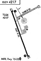
| Runways: | 15/33 |
| Longest Runway: | 15/33 is 5199 ft (1585 m) long |
| Runways with an Instrument Approach: | 33 |
KITR Airport Runway Details
| Runway 15/33 | 5199 ft x 75 ft (1585 m x 23 m) | |
| Surface: | Asphalt - Good condition - No special surface treatment | |
| Runway Edge Lights: | Medium Intensity | |
Runway Weight Bearing Capacity (in thousands of pounds) |
||
| Single Wheel Landing Gear: | 17.0 | |
| Dual Wheel Landing Gear: | 17.0 | |
Runway 15 |
Runway 33 |
|
Elevation: |
4218.3 | 4201.5 |
Latitude: |
39-14-57.1635N | 39-14-08.9163N |
Longitude: |
102-17-18.7147W | 102-16-56.0046W |
|
Runway True Alignment: |
160 | 340 |
ILS Type: |
LOC/DME | |
Glide Path Angle: |
3.0 degrees | 3.0 degrees |
Runway Markings Type: |
Nonprecision Instrument | Nonprecision Instrument |
Runway Markings Condition: |
Good | Good |
Visual Glide Slope Indicators: |
4-Light PAPI On Left Side Of Runway | 4-Light PAPI On Left Side Of Runway |
REIL: |
Yes | Yes |
Threshold Crossing Height: |
31 | 32 |
Services
Airframe Repair: |
Minor |
Powerplant Repair: |
Minor |
Bottled Oxygen: |
None |
Bulk Oxygen: |
None |
Landing Fees: |
No |
Parking: |
Hangars and tiedowns available |
Maps & Diagrams
KITR Sectional
Flight Planning
at skyvector.com
at skyvector.com