Location
Latitude: |
35-51-26.7504N (35.857431) |
Longitude: |
102-00-47.9133W (-102.013309) |
Elevation: |
3706.4 feet MSL (1130 m MSL) |
Magnetic Variation: |
5.8 E (as of April 2024 from WMM2020 model) |
Time Zone: |
UTC -6.0 (Standard Time) UTC -5.0 (Daylight Savings Time) |
From City: |
02 N.M. W of Dumas, Texas |
Found On: |
Albuquerque Chart |
FAA Region: |
ASW |
Contacts
Manager: |
Publicly owned: |
| BRANDON COX 5932 US 87 DUMAS, TX 79029 806-935-6995 |
MOORE COUNTY 715 DUMAS AVE. RM 202 DUMAS, TX 79029 806-935-5588 |
Operations
Airport Status: |
Operational |
Facility Use: |
Public |
Type: |
Airport |
Activation Date: |
08/1955 |
Control tower: |
No |
Attendance (Months/Days/Hours): |
Months/Days/Hours ALL/ALL/0800-1700 |
Boundary ARTCC: |
ZAB (Albuquerque) |
Responsible ARTCC: |
ZAB (Albuquerque) |
Lighting Schedule: |
SEE RMK |
Segmented Circle Indicator: |
Yes |
Traffic Pattern Altitude (MSL): |
4706 feet (1434 m) |
NOTAMs Facility: |
DUX |
NOTAM-D Service: |
Yes |
International Airport of Entry: |
No |
Customs Landing Rights: |
No |
Military Landing Rights: |
Yes |
Civil/Military Joint Use: |
No |
Based Aircraft
| Single Engine: | 11 |
| Multi Engine: | 3 |
Annual Operations (as of 10/11/2017)
| Total Operations: | 10210 | |
| GA Local: | 10000 | 97.9% |
| GA Itinerant: | 200 | 2.0% |
| Military Aircraft: | 10 | 0.1% |
Communications
| CTAF: | 122.800 |
| Unicom: | 122.800 |
| AWOS-3: | 118.075 (806-934-3390) |
- APCH/DEP SVC PRVDD BY ALBUQUERQUE ARTCC (ZAB) ON FREQS 127.85/285.475 (AMARILLO RCAG).
Fixed Based Operators (FBOs) & Fuel
(Click on a business for detail)
Please help us keep this information up to date. This is a FREE SERVICE just like everything else on Airport Guide! If you see that a business needs to be added, modified, or deleted please fill out our Update Form.
To add, modify, or delete a business click here.
Please help us keep this information up to date. This is a FREE SERVICE just like everything else on Airport Guide! If you see that a business needs to be added, modified, or deleted please fill out our Update Form.
Area Code: 806 |
| Business Name | Frequency | Phone | Fuel Grade |
|---|---|---|---|
| Moore County Airport
Update FBO info |
Unicom 122.8 | 935-6995 | 100LL, Jet A |
Flight Service Stations
| Primary | Alternate | |
| FSS on Field: | N | |
| FSS Name (ID): | Fort Worth(FTW) | |
| Frequency: | ||
| Toll Free Phone: | 1-800-WX-BRIEF |
Instrument Procedures / Charts
FAA Terminal Procedures valid from 0901Z 03/21/24 to 0901Z 04/18/24.
There are various types of charts available for an airport. They are listed in the Page Type column. Here is a legend for those types:
APD - Airport Diagram
DP - Departure Procedure Charts
HOT - Hot Spots
IAP - Instrument Approach Procedure Charts
MIN - Minimums
STAR - Standard Terminal Arrival Charts
| Page Type | Page Name | Volume | Action Since Last Cycle |
|---|---|---|---|
| IAP | RNAV (GPS) RWY 01 | SC-2 | |
| IAP | RNAV (GPS) RWY 19 | SC-2 | |
| MIN | ALTERNATE MINIMUMS | SC-2 | |
| MIN | TAKEOFF MINIMUMS | SC-2 |
Terminal Procedures are only available for airports in several countries with more being added all the time. If you are looking for a specific country's charts, please send an email to support(at)airportguide.com stating the country name. This will be used to prioritize the implementation.
Navigation Aids (Navaids) near KDUX
| Dist (NM) | ID | Morse Code | Name | Type | Freq | True Hdg | Mag Hdg |
|---|---|---|---|---|---|---|---|
| 29.4 | DHT | _ . . . . . . _ | Dalhart | VORTAC | 112.00 | 298 | 292 |
| 30.8 | BGD | _ . . . _ _ . _ . . | Borger | TACAN | 108.60 | 95 | 89 |
| 40.4 | PNH | . _ _ . _ . . . . . | Panhandle | VORTAC | 116.60 | 157 | 151 |
| 43.8 | AM | . _ _ _ | Pande | NDB | 251 | 166 | 160 |
| 51.9 | PPA | . _ _ . . _ _ . . _ | Pampa | NDB | 368 | 106 | 101 |
| 56.5 | GUY | _ _ . . . _ _ . _ _ | Guymon | NDB | 275 | 25 | 19 |
| 61.9 | HRX | . . . . . _ . _ . . _ | Hereford | NDB | 341 | 194 | 188 |
| 65.3 | CAO | _ . _ . . _ _ _ _ | Clayton | NDB | 332 | 302 | 296 |
| 68.9 | EHA | . . . . . . _ | Elkhart | NDB | 377 | 5 | 359 |
| 69.8 | PYX | . _ _ . _ . _ _ _ . . _ | Perryton | NDB | 266 | 61 | 56 |
| 83.8 | LB | . _ . . _ . . . | Panck | NDB | 383 | 37 | 32 |
| 84.2 | HQG | . . . . _ _ . _ _ _ . | Hugoton | NDB | 365 | 21 | 15 |
| 87.2 | LBL | . _ . . _ . . . . _ . . | Liberal | TACAN | 112.30 | 34 | 28 |
| 87.4 | TCC | _ _ . _ . _ . _ . | Tucumcari | VORTAC | 113.60 | 242 | 236 |
| 91.2 | TXO | _ _ . . _ _ _ _ | Texico | VORTAC | 112.20 | 206 | 200 |
Nearby Airports with Fuel
Notices to Airmen (NOTAMS)
Remarks
| A110-1 | EXTENSIVE CROP DUSTING IN SUMMER. |
| A110-2 | FOR CD CTC ALBUQUERQUE ARTCC AT 505-856-4861. |
| A17 | FOR SVCS AFT HRS CALL 806-935-6995 OR 806-676-6412. |
| A70-FUEL-10 | 0LL 100 LL SELF-SERVE FUEL AVBL 24 HRS WITH MAJOR CREDIT CARD |
| A81-APT | MIRL RWY 01/19 PRESET LOW INTST; TO INCR INTST ACTVT - CTAF. PAPI RWY 01 & 19 OPR CONSLY. |
Runways
Runway Summary
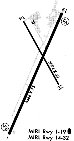
| Runways: | 01/19 14/32 |
| Longest Runway: | 01/19 is 6001 ft (1829 m) long |
| Runways with an Instrument Approach: |
KDUX Airport Runway Details
| Runway 01/19 | 6001 ft x 100 ft (1829 m x 30 m) | |
| Runway Length Source: | STATE as of 02/22/2010 | |
| Surface: | Asphalt - Good condition - No special surface treatment | |
| Runway Edge Lights: | Medium Intensity | |
Runway Weight Bearing Capacity (in thousands of pounds) |
||
| Single Wheel Landing Gear: | 30.0 | |
| Dual Wheel Landing Gear: | 45.0 | |
Runway 01 |
Runway 19 |
|
Elevation: |
3706.4 | 3698.1 |
Latitude: |
35-50-55.6401N | 35-51-50.2157N |
Longitude: |
102-01-03.4439W | 102-00-34.7920W |
|
Runway True Alignment: |
023 | 203 |
Glide Path Angle: |
3.0 degrees | 3.0 degrees |
Traffic Pattern: |
Left | Left |
Runway Markings Type: |
Nonprecision Instrument | Nonprecision Instrument |
Runway Markings Condition: |
Good | Good |
Object at End: |
ROAD | |
Object Height: |
15 | |
Distance from End: |
500 | |
Object Centerline Offset: |
295 ft. right of centerline | |
Visual Glide Slope Indicators: |
4-Light PAPI On Left Side Of Runway | 4-Light PAPI On Left Side Of Runway |
Threshold Crossing Height: |
50 | 50 |
| Runway 14/32 | 3100 ft x 60 ft (945 m x 18 m) | |
| Runway Length Source: | NGS as of 10/02/1997 | |
| Surface: | Asphalt - Good condition - No special surface treatment | |
| Runway Edge Lights: | Medium Intensity | |
Runway Weight Bearing Capacity (in thousands of pounds) |
||
| Single Wheel Landing Gear: | 21.0 | |
| Dual Wheel Landing Gear: | 32.0 | |
Runway 14 |
Runway 32 |
|
Elevation: |
3698.5 | 3700.1 |
Latitude: |
35-51-47.6247N | 35-51-20.6751N |
Longitude: |
102-00-54.5447W | 102-00-36.6182W |
|
Runway True Alignment: |
152 | 332 |
Glide Path Angle: |
0.0 degrees | 0.0 degrees |
Traffic Pattern: |
Left | Left |
Runway Markings Type: |
Basic | Basic |
Runway Markings Condition: |
Good | Good |
Object at End: |
PLINE | |
Object Height: |
29 | |
Distance from End: |
790 | |
Object Centerline Offset: |
295 ft. right of centerline |
Services
Airframe Repair: |
Major |
Powerplant Repair: |
Major |
Fuel Available: |
100LL, Jet A |
Landing Fees: |
No |
Maps & Diagrams
KDUX Sectional
Flight Planning
at skyvector.com
at skyvector.com