Location
Latitude: |
39-25-59.8550N (39.433293) |
Longitude: |
098-40-48.0650W (-98.680018) |
Elevation: |
1547.0 feet MSL (472 m MSL) |
Magnetic Variation: |
4 E (as of April 2024 from WMM2020 model) |
Time Zone: |
UTC -6.0 (Standard Time) UTC -5.0 (Daylight Savings Time) |
From City: |
01 N.M. SE of Osborne, Kansas |
Found On: |
Wichita Chart |
FAA Region: |
ACE |
Contacts
Manager: |
Publicly owned: |
| BARRY CURRY, AIRPORT MANAGER 128 N FIRST OSBORNE, KS 67473 785-476-5270 |
CITY OF OSBORNE 128 N FIRST OSBORNE, KS 67473 785-346-5611 |
Operations
Airport Status: |
Operational |
Facility Use: |
Public |
Type: |
Airport |
Activation Date: |
03/1947 |
Control tower: |
No |
Attendance (Months/Days/Hours): |
Months/Days/Hours ON CALL |
Boundary ARTCC: |
ZKC (Kansas City) |
Responsible ARTCC: |
ZKC (Kansas City) |
Segmented Circle Indicator: |
No |
Traffic Pattern Altitude (MSL): |
2547 feet (776 m) |
NOTAMs Facility: |
ICT |
NOTAM-D Service: |
Yes |
Civil/Military Joint Use: |
No |
Based Aircraft
| Single Engine: | 7 |
| Ultralights: | 3 |
Annual Operations (as of 09/27/2018)
| Total Operations: | 5912 | |
| Air Taxi: | 700 | 11.8% |
| GA Local: | 3600 | 60.9% |
| GA Itinerant: | 1600 | 27.1% |
| Military Aircraft: | 12 | 0.2% |
Communications
| CTAF: | 122.900 |
| AWOS-3: | 120.025 (785-345-4998) |
Fixed Based Operators (FBOs) & Fuel
(Click on a business for detail)
Please help us keep this information up to date. This is a FREE SERVICE just like everything else on Airport Guide! If you see that a business needs to be added, modified, or deleted please fill out our Update Form.
To add, modify, or delete a business click here.
Please help us keep this information up to date. This is a FREE SERVICE just like everything else on Airport Guide! If you see that a business needs to be added, modified, or deleted please fill out our Update Form.
Area Code: 785 |
| Business Name | Frequency | Phone | Fuel Grade |
|---|---|---|---|
| Osborn Aviation
Update FBO info |
346-2341 | 100LL |
Flight Service Stations
| Primary | Alternate | |
| FSS on Field: | N | |
| FSS Name (ID): | Wichita(ICT) | |
| Frequency: | ||
| Toll Free Phone: | 1-800-WX-BRIEF |
Instrument Procedures / Charts
Terminal Procedures are only available for airports in several countries with more being added all the time. If you are looking for a specific country's charts, please send an email to support(at)airportguide.com stating the country name. This will be used to prioritize the implementation.
Navigation Aids (Navaids) near K75
| Dist (NM) | ID | Morse Code | Name | Type | Freq | True Hdg | Mag Hdg |
|---|---|---|---|---|---|---|---|
| 29.6 | TKO | _ _ . _ _ _ _ | Mankato | VORTAC | 109.80 | 40 | 36 |
| 32.5 | PHG | . _ _ . . . . . _ _ . | Phillipsburg | NDB | 368 | 300 | 296 |
| 44.8 | HYS | . . . . _ . _ _ . . . | Hays | VORTAC | 110.40 | 218 | 214 |
| 47.9 | HY | . . . . _ . _ _ | Nette | NDB | 374 | 213 | 209 |
| 48.2 | CNK | _ . _ . _ . _ . _ | Concordia | NDB | 335 | 81 | 77 |
| 52.5 | RPB | . _ . . _ _ . _ . . . | Republican | NDB | 414 | 63 | 59 |
| 57.9 | SLN | . . . . _ . . _ . | Salina | VORTAC | 117.10 | 121 | 117 |
| 61.4 | NRN | _ . . _ . _ . | Norton | NDB | 230 | 294 | 290 |
| 65.3 | HIL | . . . . . . . _ . . | Hilyn | NDB | 338 | 189 | 185 |
| 66.0 | SL | . . . . _ . . | Flory | NDB | 344 | 132 | 128 |
| 66.2 | HJH | . . . . . _ _ _ . . . . | Hebron | NDB | 323 | 49 | 45 |
| 68.5 | LYO | . _ . . _ . _ _ _ _ _ | Lyons | NDB | 386 | 161 | 157 |
| 70.5 | CYW | _ . _ . _ . _ _ . _ _ | Clay Center | NDB | 362 | 92 | 89 |
| 71.2 | HSI | . . . . . . . . . | Hastings | VOR-DME | 108.80 | 9 | 5 |
| 71.4 | GB | _ _ . _ . . . | Babsy | NDB | 419 | 186 | 182 |
| 72.5 | HLC | . . . . . _ . . _ . _ . | Hill City | VORTAC | 113.70 | 262 | 258 |
| 73.3 | EA | . . _ | Anoke | NDB | 422 | 347 | 343 |
| 75.8 | PSS | . _ _ . . . . . . . | Prosser | NDB | 338 | 6 | 2 |
| 76.2 | LQR | . _ . . _ _ . _ . _ . | Larned | NDB | 296 | 194 | 190 |
| 79.0 | EAR | . . _ . _ . | Kearney | VOR | 111.20 | 349 | 345 |
Nearby Airports with Fuel
Notices to Airmen (NOTAMS)
Remarks
| A110-1 | PUBLIC TELEPHONE AVAILABLE. |
| A110-2 | OCCASSIONAL RC MODEL AIRPLANE ACTIVITY. |
| A110-3 | FOR CD CTC KANSAS CITY ARTCC AT 913-254-8508. |
| A17 | FOR ATTENDANT CALL 785-346-2001. |
| A30-12/30 | OPEN SR-SS ONLY. |
| A40-02/20 | RY 02/20 THLD LGTS ARE TAXIWAY BLUE AND POORLY SPACED. |
| A42-12 | RY 12 THLD & EDGES MKD WITH METAL MARKERS PAINTED RED & WHITE. |
| A42-30 | RY 30 THLD & EDGES MARKED WITH METAL MKRS PAINTED RED AND WHITE. |
| A52-12 | GRAIN ELEVATOR |
| A52-30 | CROPS SURROUNDING RWY VARYS IN HEIGHT UP TO 6 FT. |
| A57-02 | RWY 02 APCH RATIO 7:1 TO DSPLCD THLD. |
| A57-20 | APCH RATIO 20:1 TO DSPLCD THLD. |
| A58-20 | ROAD SHOWN AS THE CONTROLLING OBSTRUCTION TO RY 20 WAS MEASURED TO BE INSIDE OF THE PRIMARY SURFACE MAKING IT A CLOSE IN OBSTRUCTION, HAD A DISPLACED THR. NOT BEEN ESTABLISHED THIS APPROACH WOULD BE 50:1. |
| A70-FUEL-10 | 0LL FOR FUEL CALL 785-346-2926 OR 346-2290 |
| A83 | A TETRAHEDRON IS ALSO AVBL FOR WIND DIRECTION. |
| E111 | PROVIDED THE APPROACH TO EACH RWY IS MAINTAINED FOR A MINIMUM 20:1 GLIDE SLOPE AND THE TRANSITIONAL SURFACE BE MAINTAINED FOR A 7:1 SLOPE. |
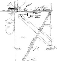
Runways
Runway Summary
| Runways: | 02/20 12/30 |
| Longest Runway: | 02/20 is 4206 ft (1282 m) long |
| Runways with an Instrument Approach: |
K75 Airport Runway Details
| Runway 02/20 | 4206 ft x 60 ft (1282 m x 18 m) | |
| Runway Length Source: | 3RD PARTY SURVEY as of 09/10/2010 | |
| Surface: | Asphalt - Good condition - No special surface treatment | |
| Runway Edge Lights: | Medium Intensity | |
Runway 02 |
Runway 20 |
|
Elevation: |
1546.9 | 1543.1 |
Latitude: |
39-25-40.5133N | 39-26-16.0111N |
Longitude: |
098-41-02.1107W | 098-40-34.2257W |
Glide Path Angle: |
0.0 degrees | 0.0 degrees |
Runway Markings Type: |
Nonprecision Instrument | Nonprecision Instrument |
Runway Markings Condition: |
Good | Good |
Object at End: |
TREES | ROAD |
Object Height: |
29 | 15 |
Distance from End: |
291 | 120 |
Object Centerline Offset: |
0 ft. left and right of centerline | 0 ft. left and right of centerline |
Threshold Elevation: |
1546.8 | 1543.3 |
Displaced Threshold: |
101 | 152 |
Threshold Latitude: |
39-25-41.3639N | 39-26-14.7276N |
Threshold Longitude: |
098-41-01.4427W | 098-40-35.2336W |
| Runway 12/30 | 2907 ft x 80 ft (886 m x 24 m) | |
| Runway Length Source: | 3RD PARTY SURVEY as of 09/10/2010 | |
| Surface: | Asphalt - Good condition - No special surface treatment | |
Runway 12 |
Runway 30 |
|
Elevation: |
1547.0 | 1540.0 |
Latitude: |
39-26-12.6254N | 39-25-51.6916N |
Longitude: |
098-41-00.5974W | 098-40-35.2341W |
Glide Path Angle: |
0.0 degrees | 0.0 degrees |
Traffic Pattern: |
Left | Left |
Runway Markings Type: |
Nonstandard (other than numbers only) | Nonstandard (other than numbers only) |
Object at End: |
OTHER | BERM |
Object Height: |
244 | 5 |
Distance from End: |
3760 | 109 |
Object Centerline Offset: |
0 ft. left and right of centerline | 0 ft. left and right of centerline |
Services
Airframe Repair: |
Major |
Powerplant Repair: |
Major |
Bottled Oxygen: |
None |
Bulk Oxygen: |
None |
Fuel Available: |
100LL, Jet A, MOGAS |
Landing Fees: |
No |
Parking: |
Hangars and tiedowns available |
Maps & Diagrams
K75 Sectional
Flight Planning
at skyvector.com
at skyvector.com