Location
Latitude: |
38-48-24.6540N (38.806848) |
Longitude: |
094-57-24.2980W (-94.956749) |
Elevation: |
1040.0 feet MSL (317 m MSL) |
Magnetic Variation: |
1.5 E (as of April 2024 from WMM2020 model) |
Time Zone: |
UTC -6.0 (Standard Time) UTC -5.0 (Daylight Savings Time) |
From City: |
01 N.M. W of Gardner, Kansas |
Found On: |
Kansas City Chart |
FAA Region: |
ACE |
Contacts
Manager: |
Publicly owned: |
| KELLEN HEADLEE 120 E. MAIN ST., 31905 W 175 ST GARDNER, KS 66030 913-856-0914 |
CITY OF GARDNER CITY HALL, 120 E MAIN ST. GARDNER, KS 66030 913-856-0914 |
Operations
Airport Status: |
Operational |
Facility Use: |
Public |
Type: |
Airport |
Activation Date: |
05/1941 |
Control tower: |
No |
Attendance (Months/Days/Hours): |
Months/Days/Hours ALL/ALL/0800-1700 |
Boundary ARTCC: |
ZKC (Kansas City) |
Responsible ARTCC: |
ZKC (Kansas City) |
Lighting Schedule: |
SS-SR |
Segmented Circle Indicator: |
No |
Traffic Pattern Altitude (MSL): |
2040 feet (622 m) |
NOTAMs Facility: |
COU |
NOTAM-D Service: |
Yes |
International Airport of Entry: |
No |
Customs Landing Rights: |
No |
Military Landing Rights: |
Yes |
Civil/Military Joint Use: |
No |
Based Aircraft
| Single Engine: | 74 |
| Multi Engine: | 1 |
| Gliders: | 5 |
Annual Operations (as of 08/31/2020)
| Total Operations: | 27300 | |
| GA Local: | 19110 | 70.0% |
| GA Itinerant: | 8190 | 30.0% |
Communications
| CTAF: | 122.800 |
| Unicom: | 122.800 |
| Approach: | KANSAS CITY 118.9 118.9 |
| Departure: | KANSAS CITY 118.9 118.9 |
Fixed Based Operators (FBOs) & Fuel
(Click on a business for detail)
Please help us keep this information up to date. This is a FREE SERVICE just like everything else on Airport Guide! If you see that a business needs to be added, modified, or deleted please fill out our Update Form.
To add, modify, or delete a business click here.
Please help us keep this information up to date. This is a FREE SERVICE just like everything else on Airport Guide! If you see that a business needs to be added, modified, or deleted please fill out our Update Form.
Area Code: 913 |
| Business Name | Frequency | Phone | Fuel Grade |
|---|---|---|---|
| Gardner Aviation
Update FBO info |
Unicom 122.8 | 856-4039 | 100LL, MOGAS |
| Sun Aviation
Update FBO info |
856-6951 |
Flight Service Stations
| Primary | Alternate | |
| FSS on Field: | N | |
| FSS Name (ID): | Columbia(COU) | |
| Frequency: | ||
| Toll Free Phone: | 1-800-WX-BRIEF |
Instrument Procedures / Charts
| Page Type | Page Name | Volume | Action Since Last Cycle |
|---|
Terminal Procedures are only available for airports in several countries with more being added all the time. If you are looking for a specific country's charts, please send an email to support(at)airportguide.com stating the country name. This will be used to prioritize the implementation.
Navigation Aids (Navaids) near K34
| Dist (NM) | ID | Morse Code | Name | Type | Freq | True Hdg | Mag Hdg |
|---|---|---|---|---|---|---|---|
| 10.5 | OJC | _ _ _ . _ _ _ _ . _ . | Johnson County | VOR-DME | 113.00 | 78 | 77 |
| 10.8 | PK | . _ _ . _ . _ | Herbb | NDB | 420 | 107 | 106 |
| 11.2 | JZ | . _ _ _ _ _ . . | Newbn | NDB | 338 | 304 | 302 |
| 20.7 | GQ | _ _ . _ _ . _ | Norge | NDB | 517 | 42 | 41 |
| 25.2 | RIS | . _ . . . . . . | Riverside | VOR-DME | 111.40 | 41 | 40 |
| 25.3 | MKC | _ _ _ . _ _ . _ . | Kansas City Downtown | VOT | 108.60 | 41 | 40 |
| 26.6 | DO | _ . . _ _ _ | Dotte | NDB | 359 | 21 | 20 |
| 29.6 | FO | . . _ . _ _ _ | Riply | NDB | 326 | 279 | 277 |
| 30.5 | MCI | _ _ _ . _ . . . | Kansas City | VORTAC | 113.25 | 19 | 18 |
| 34.0 | FOE | . . _ . _ _ _ . | Forbes | TACAN | 111.60 | 284 | 282 |
| 34.0 | TOP | _ _ _ _ . _ _ . | Topeka | VORTAC | 117.80 | 305 | 303 |
| 34.3 | FOE | . . _ . _ _ _ . | Forbes | VOT | 111.00 | 284 | 282 |
| 38.9 | BUM | _ . . . . . _ _ _ | Butler | VORTAC | 115.90 | 145 | 144 |
| 38.9 | TO | _ _ _ _ | Biloy | NDB | 521 | 299 | 297 |
| 42.3 | ANX | . _ _ . _ . . _ | Napoleon | VORTAC | 114.00 | 65 | 64 |
| 47.0 | UKL | . . _ _ . _ . _ . . | Boyd | NDB | 245 | 229 | 227 |
| 52.2 | ST | . . . _ | Tario | NDB | 260 | 2 | 1 |
| 61.3 | FSK | . . _ . . . . _ . _ | Fort Scott | NDB | 379 | 171 | 170 |
| 63.5 | EMP | . _ _ . _ _ . | Emporia | VORTAC | 112.80 | 241 | 239 |
| 64.6 | MSB | _ _ . . . _ . . . | Monarch | NDB | 410 | 199 | 197 |
Nearby Airports with Fuel
Notices to Airmen (NOTAMS)
Remarks
| A110-1 | GLIDER & ULTRALIGHT ACT ON & INVOF ARPT. |
| A110-2 | FUEL AVBL 24 HRS W/CREDIT CARD. |
| A110-3 | FOR CD CTC KANSAS CITY APCH AT 816-329-2710. |
| A110-4 | ACCESS TO RWY 17 THLD VIA RWY 8 OVERRUN. |
| A30-17/35 | RWY ENDS MKD WITH ORANGE BARRELS. |
| A40-08/26 | NSTD LIRL; LGTS PLACED 35 FT OUT FROM RWY EDGE AT 240 FT SPACINGS; NO RWY END LGTS; NO RWY 26 DSPLCD THLD LGTS. |
| A40-17/35 | NO RWY END LGTS. |
| A52-03 | +31 FT TREES R EDGE OF RWY APRX 400 FT DOWN RWY. |
| A57-26 | DSPLCD THLD APCH RATIO 31:1. |
| A70-FUEL-MO | GAS 87 OCTANE UNLEADED AUTO GAS. |
| E111 | PROVIDED THE APPROACH TO EACH RWY IS MAINTAINED FOR A MINIMUM 20:1 GLIDE SLOPE AND THE TRANSITIONAL SURFACE BE MAINTAINED FOR A 7:1 SLOPE. |
Runways
Runway Summary
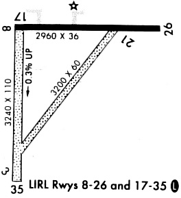
| Runways: | 03/21 08/26 17/35 |
| Longest Runway: | 17/35 is 3224 ft (983 m) long |
| Runways with an Instrument Approach: |
K34 Airport Runway Details
| Runway 03/21 | 1871 ft x 60 ft (570 m x 18 m) | |
| Runway Length Source: | FAA as of 07/20/2020 | |
| Surface: | Turf - Good condition - No special surface treatment | |
Runway 03 |
Runway 21 |
|
Elevation: |
1032.0 | 1031.0 |
Latitude: |
38-48-12.0500N | 38-48-27.3800N |
Longitude: |
094-57-29.2100W | 094-57-16.0000W |
|
Runway True Alignment: |
034 | 214 |
Glide Path Angle: |
0.0 degrees | 0.0 degrees |
Runway Markings Type: |
Numbers Only | Numbers Only |
Runway Markings Condition: |
Poor | Poor |
Object at End: |
TREE | |
Object Height: |
33 | |
Distance from End: |
627 | |
Object Centerline Offset: |
99 ft. left of centerline |
| Runway 08/26 | 2399 ft x 36 ft (731 m x 11 m) | |
| Runway Length Source: | FAA OE/AAA as of 10/21/2021 | |
| Surface: | Turf - Good condition - No special surface treatment | |
| Runway Pavement Class: | 3 /F/C/Y/U | |
| Runway Edge Lights: | Low Intensity | |
Runway Weight Bearing Capacity (in thousands of pounds) |
||
| Single Wheel Landing Gear: | 6.0 | |
Runway 08 |
Runway 26 |
|
Elevation: |
1029.7 | 1033.4 |
Latitude: |
38-48-35.8200N | 38-48-35.7800N |
Longitude: |
094-57-31.1000W | 094-57-00.7900W |
|
Runway True Alignment: |
090 | 270 |
Glide Path Angle: |
0.0 degrees | 0.0 degrees |
Traffic Pattern: |
Left | Left |
Runway Markings Type: |
Basic | Basic |
Runway Markings Condition: |
Good | Good |
Object at End: |
FENCE | |
Object Height: |
3 | |
Distance from End: |
311 | |
Object Centerline Offset: |
99 ft. left of centerline |
| Runway 17/35 | 3224 ft x 60 ft (983 m x 18 m) | |
| Runway Length Source: | FAA as of 07/20/2020 | |
| Surface: | Turf - Good condition - No special surface treatment | |
| Runway Edge Lights: | Low Intensity | |
Runway 17 |
Runway 35 |
|
Elevation: |
1029.0 | 1040.0 |
Latitude: |
38-48-35.1600N | 38-48-03.2900N |
Longitude: |
094-57-31.6400W | 094-57-31.3500W |
|
Runway True Alignment: |
180 | 000 |
Glide Path Angle: |
0.0 degrees | 0.0 degrees |
Traffic Pattern: |
Left | Left |
Runway Markings Type: |
Nonstandard (other than numbers only) | Nonstandard (other than numbers only) |
Runway Markings Condition: |
Good | Good |
Object at End: |
TREES | |
Object Height: |
62 | |
Distance from End: |
826 | |
Object Centerline Offset: |
99 ft. left of centerline |
Services
Airframe Repair: |
Major |
Powerplant Repair: |
Major |
Bottled Oxygen: |
None |
Bulk Oxygen: |
None |
Fuel Available: |
100LL, Jet A |
Parking: |
Hangars and tiedowns available |
Maps & Diagrams
K34 Sectional
Flight Planning
at skyvector.com
at skyvector.com