Location
Latitude: |
41-03-08.0000N (41.052222) |
Longitude: |
093-41-20.9000W (-93.689139) |
Elevation: |
1115.2 feet MSL (340 m MSL) |
Magnetic Variation: |
0.5 E (as of April 2024 from WMM2020 model) |
Time Zone: |
UTC -6.0 (Standard Time) UTC -5.0 (Daylight Savings Time) |
From City: |
04 N.M. NE of Osceola, Iowa |
Found On: |
Omaha Chart |
FAA Region: |
ACE |
Contacts
Manager: |
Publicly owned: |
| LINDA PERSELS 1754 - 270TH AVENUE OSCEOLA, IA 50213 641-340-5670 |
CITY OF OSCEOLA 115 NORTH FILLMORE OSCEOLA, IA 50213 641-347-7437 |
Operations
Airport Status: |
Operational |
Facility Use: |
Public |
Type: |
Airport |
Activation Date: |
11/1987 |
Control tower: |
No |
Attendance (Months/Days/Hours): |
Months/Days/Hours APR-OCT/MON - FRI/0800-1500 |
Boundary ARTCC: |
ZMP (Minneapolis) |
Responsible ARTCC: |
ZMP (Minneapolis) |
Lighting Schedule: |
SEE RMK |
Segmented Circle Indicator: |
No |
Traffic Pattern Altitude (MSL): |
2115 feet (645 m) |
NOTAMs Facility: |
I75 |
NOTAM-D Service: |
Yes |
Based Aircraft
| Single Engine: | 28 |
Annual Operations (as of 04/06/2022)
| Total Operations: | 8750 | |
| GA Local: | 7000 | 80.0% |
| GA Itinerant: | 1750 | 20.0% |
Communications
| CTAF: | 122.800 |
| Unicom: | 122.800 |
| Approach: | DES MOINES 123.9 123.9 |
| Departure: | DES MOINES 123.9 123.9 |
| AWOS-3: | 120.975 (641-342-1422) |
Fixed Based Operators (FBOs) & Fuel
(Click on a business for detail)
Please help us keep this information up to date. This is a FREE SERVICE just like everything else on Airport Guide! If you see that a business needs to be added, modified, or deleted please fill out our Update Form.
To add, modify, or delete a business click here.
Please help us keep this information up to date. This is a FREE SERVICE just like everything else on Airport Guide! If you see that a business needs to be added, modified, or deleted please fill out our Update Form.
Area Code: 641 |
| Business Name | Frequency | Phone | Fuel Grade |
|---|
Flight Service Stations
| Primary | Alternate | |
| FSS on Field: | ||
| FSS Name (ID): | Fort Dodge(FOD) | |
| Frequency: | ||
| Toll Free Phone: | 1-800-WX-BRIEF |
Instrument Procedures / Charts
FAA Terminal Procedures valid from 0901Z 03/21/24 to 0901Z 04/18/24.
There are various types of charts available for an airport. They are listed in the Page Type column. Here is a legend for those types:
APD - Airport Diagram
DP - Departure Procedure Charts
HOT - Hot Spots
IAP - Instrument Approach Procedure Charts
MIN - Minimums
STAR - Standard Terminal Arrival Charts
| Page Type | Page Name | Volume | Action Since Last Cycle |
|---|---|---|---|
| IAP | RNAV (GPS) RWY 18 | NC-3 | |
| IAP | RNAV (GPS) RWY 36 | NC-3 | |
| MIN | ALTERNATE MINIMUMS | NC-3 | |
| MIN | TAKEOFF MINIMUMS | NC-3 |
Terminal Procedures are only available for airports in several countries with more being added all the time. If you are looking for a specific country's charts, please send an email to support(at)airportguide.com stating the country name. This will be used to prioritize the implementation.
Navigation Aids (Navaids) near I75
| Dist (NM) | ID | Morse Code | Name | Type | Freq | True Hdg | Mag Hdg |
|---|---|---|---|---|---|---|---|
| 23.2 | DSM | _ . . . . . _ _ | Des Moines | VORTAC | 117.50 | 4 | 4 |
| 29.2 | DSM | _ . . . . . _ _ | Des Moines | VOT | 109.20 | 2 | 2 |
| 30.1 | LMN | . _ . . _ _ _ . | Lamoni | VOR-DME | 116.70 | 204 | 203 |
| 30.3 | UNE | . . _ _ . . | Union County | NDB | 379 | 259 | 258 |
| 39.7 | PEA | . _ _ . . . _ | Pella | NDB | 257 | 57 | 57 |
| 48.4 | CRZ | _ . _ . . _ . _ _ . . | Corning | NDB | 278 | 266 | 265 |
| 51.1 | EE | . . | Merle | NDB | 362 | 1 | 1 |
| 51.1 | TNU | _ _ . . . _ | Newton | VOR-DME | 112.50 | 30 | 30 |
| 55.3 | OOA | _ _ _ _ _ _ . _ | Oskaloosa | NDB | 414 | 78 | 78 |
| 58.5 | TRX | _ . _ . _ . . _ | Trenton | NDB | 400 | 175 | 175 |
| 60.0 | BEX | _ . . . . _ . . _ | Bloomfield | NDB | 269 | 107 | 107 |
| 61.7 | OTM | _ _ _ _ _ _ | Ottumwa | VOR-DME | 111.60 | 90 | 90 |
| 63.8 | ICL | . . _ . _ . . _ . . | Clarinda | NDB | 353 | 252 | 251 |
| 64.7 | EFW | . . . _ . . _ _ | Jefferson | NDB | 391 | 333 | 332 |
| 64.8 | AIO | . _ . . _ _ _ | Atlantic | NDB | 365 | 289 | 288 |
| 66.9 | ADU | . _ _ . . . . _ | Audubon | NDB | 266 | 305 | 304 |
| 70.9 | RDK | . _ . _ . . _ . _ | Red Oak | NDB | 230 | 268 | 267 |
| 72.6 | JWJ | . _ _ _ . _ _ . _ _ _ | Elmwood | DME | 109.4 | 28 | 28 |
| 74.4 | IRK | . . . _ . _ . _ | Kirksville | VORTAC | 114.60 | 137 | 137 |
| 77.0 | CHT | _ . _ . . . . . _ | Chillicothe | NDB | 375 | 173 | 173 |
Nearby Airports with Fuel
Notices to Airmen (NOTAMS)
Remarks
| A110-3 | RY 18 IS CALM WIND RY. |
| A110-4 | FOR CD CTC DES MOINES ATCT AT 515-974- 8016. |
| A16 | OFFICE PHONE NUMBER 641-342-7437. |
| A70-FUEL-10 | 0LL 24 HOUR CREDIT CARD FUEL AVAILABLE |
| A81-APT | ACTVT MIRL RY 18/36; PAPI RYS 18 & 36 & REILS 18/36 - CTAF. |
| E111 | AIRSPACE DETERMINATION PENDING. |
Runways
Runway Summary
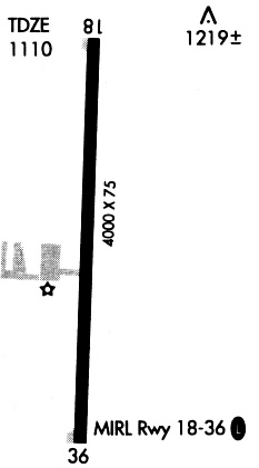
| Runways: | 18/36 |
| Longest Runway: | 18/36 is 4001 ft (1220 m) long |
| Runways with an Instrument Approach: |
I75 Airport Runway Details
| Runway 18/36 | 4001 ft x 75 ft (1220 m x 23 m) | |
| Runway Length Source: | 3RD PARTY SURVEY as of 02/26/2009 | |
| Surface: | Concrete - Good condition - No special surface treatment | |
| Runway Pavement Class: | 6 /R/C/W/T | |
| Runway Edge Lights: | Medium Intensity | |
Runway Weight Bearing Capacity (in thousands of pounds) |
||
| Single Wheel Landing Gear: | 12.5 | |
Runway 18 |
Runway 36 |
|
Elevation: |
1109.8 | 1113.8 |
Latitude: |
41-03-27.7399N | 41-02-48.2420N |
Longitude: |
093-41-19.8376W | 093-41-21.9975W |
|
Runway True Alignment: |
182 | 002 |
Glide Path Angle: |
3.0 degrees | 3.0 degrees |
Runway Markings Type: |
Nonprecision Instrument | Nonprecision Instrument |
Runway Markings Condition: |
Good | Good |
Object at End: |
TREE | ROAD |
Object Height: |
73 | 15 |
Distance from End: |
2276 | 600 |
Object Centerline Offset: |
21 ft. right of centerline | 0 ft. left and right of centerline |
Visual Glide Slope Indicators: |
2-Light PAPI On Left Side Of Runway | 2-Light PAPI On Left Side Of Runway |
REIL: |
Yes | Yes |
Threshold Crossing Height: |
31 | 31 |
Services
Airframe Repair: |
None |
Powerplant Repair: |
None |
Bottled Oxygen: |
None |
Bulk Oxygen: |
None |
Fuel Available: |
100LL, Jet A |
Landing Fees: |
No |
Parking: |
Hangars and tiedowns available |
Maps & Diagrams
I75 Sectional
Flight Planning
at skyvector.com
at skyvector.com