Location
Latitude: |
39-59-07.4000N (39.985389) |
Longitude: |
090-48-14.9000W (-90.804139) |
Elevation: |
733.7 feet MSL (224 m MSL) |
Magnetic Variation: |
1.6 W (as of April 2024 from WMM2020 model) |
Time Zone: |
UTC -6.0 (Standard Time) UTC -5.0 (Daylight Savings Time) |
From City: |
02 N.M. W of Mount Sterling, Illinois |
Found On: |
St Louis Chart |
FAA Region: |
AGL |
Contacts
Manager: |
Publicly owned: |
| PAUL WALKER 145 W. MAIN MOUNT STERLING, IL 62353 217-779-7329 |
CITY OF MOUNT STERLING 145 W. MAIN MOUNT STERLING, IL 62353 217-773-4411 |
Operations
Airport Status: |
Operational |
Facility Use: |
Public |
Type: |
Airport |
Activation Date: |
09/1972 |
Control tower: |
No |
Attendance (Months/Days/Hours): |
Months/Days/Hours IREG |
Boundary ARTCC: |
ZKC (Kansas City) |
Responsible ARTCC: |
ZKC (Kansas City) |
Lighting Schedule: |
SEE RMK |
Segmented Circle Indicator: |
No |
Traffic Pattern Altitude (MSL): |
1734 feet (529 m) |
NOTAMs Facility: |
STL |
NOTAM-D Service: |
Yes |
Based Aircraft
| Single Engine: | 9 |
| Jet Engine: | 2 |
Annual Operations (as of 05/31/2023)
| Total Operations: | 3000 | |
| GA Local: | 2000 | 66.7% |
| GA Itinerant: | 1000 | 33.3% |
Communications
| CTAF: | 122.800 |
| Unicom: | 122.800 |
| AWOS-3PT: | 118.325 (217-773-4082) |
- APCH/DEP SVC PRVDD BY KANSAS CITY ARTCC ON FREQS 126.225/317.775 (QUINCY RCAG).
Fixed Based Operators (FBOs) & Fuel
(Click on a business for detail)
Please help us keep this information up to date. This is a FREE SERVICE just like everything else on Airport Guide! If you see that a business needs to be added, modified, or deleted please fill out our Update Form.
To add, modify, or delete a business click here.
Please help us keep this information up to date. This is a FREE SERVICE just like everything else on Airport Guide! If you see that a business needs to be added, modified, or deleted please fill out our Update Form.
Area Code: 217 |
| Business Name | Frequency | Phone | Fuel Grade |
|---|---|---|---|
| City of Mt. Sterling
Update FBO info |
773-2513, 773-2063 | 100LL, Jet A |
Flight Service Stations
| Primary | Alternate | |
| FSS on Field: | ||
| FSS Name (ID): | Saint Louis(STL) | |
| Frequency: | ||
| Toll Free Phone: | 1-800-WX-BRIEF |
Instrument Procedures / Charts
FAA Terminal Procedures valid from 0901Z 03/21/24 to 0901Z 04/18/24.
There are various types of charts available for an airport. They are listed in the Page Type column. Here is a legend for those types:
APD - Airport Diagram
DP - Departure Procedure Charts
HOT - Hot Spots
IAP - Instrument Approach Procedure Charts
MIN - Minimums
STAR - Standard Terminal Arrival Charts
| Page Type | Page Name | Volume | Action Since Last Cycle |
|---|---|---|---|
| IAP | RNAV (GPS) RWY 18 | EC-3 | |
| IAP | RNAV (GPS) RWY 36 | EC-3 | |
| MIN | ALTERNATE MINIMUMS | EC-3 | |
| MIN | TAKEOFF MINIMUMS | EC-3 |
Terminal Procedures are only available for airports in several countries with more being added all the time. If you are looking for a specific country's charts, please send an email to support(at)airportguide.com stating the country name. This will be used to prioritize the implementation.
Navigation Aids (Navaids) near I63
| Dist (NM) | ID | Morse Code | Name | Type | Freq | True Hdg | Mag Hdg |
|---|---|---|---|---|---|---|---|
| 21.5 | UI | . . _ . . | Quincy | NDB | 293 | 254 | 255 |
| 23.4 | UIN | . . _ . . _ . | Quincy | TACAN | 113.60 | 249 | 250 |
| 28.9 | IJX | . . . _ _ _ _ . . _ | Jacksonville | DME | 108.6 | 115 | 117 |
| 33.9 | JZY | . _ _ _ _ _ . . _ . _ _ | Macomb | NDB | 251 | 19 | 21 |
| 40.7 | EOK | . _ _ _ _ . _ | Keokuk | NDB | 366 | 315 | 316 |
| 42.7 | BR | _ . . . . _ . | Burns | NDB | 390 | 340 | 342 |
| 44.6 | BRL | _ . . . . _ . . _ . . | Burlington | VOR-DME | 111.40 | 352 | 354 |
| 48.2 | CTK | _ . _ . _ _ . _ | Canton | NDB | 236 | 43 | 45 |
| 49.7 | SP | . . . . _ _ . | Huskk | NDB | 382 | 104 | 106 |
| 52.6 | SPI | . . . . _ _ . . . | Spinner | VORTAC | 112.70 | 99 | 101 |
| 55.4 | LQ | . _ . . _ _ . _ | Licol | NDB | 375 | 94 | 96 |
| 57.0 | CJ | _ . _ . . _ _ _ | Calde | NDB | 240 | 101 | 103 |
| 59.6 | GBG | _ _ . _ . . . _ _ . | Galesburg | DME | 109.8 | 16 | 18 |
| 62.3 | PIA | . _ _ . . . . _ | Peoria | VORTAC | 115.20 | 47 | 49 |
| 66.3 | MPZ | _ _ . _ _ . _ _ . . | Mount Pleasant | NDB | 212 | 330 | 331 |
| 66.8 | PI | . _ _ . . . | Tungg | NDB | 356 | 55 | 57 |
| 68.1 | AAA | . _ . _ . _ | Abraham | NDB | 329 | 80 | 82 |
| 69.1 | STL | . . . _ . _ . . | St Louis | VORTAC | 117.40 | 167 | 169 |
| 72.7 | LM | . _ . . _ _ | Oblio | NDB | 338 | 167 | 169 |
| 73.4 | TAZ | _ . _ _ _ . . | Taylorville | NDB | 395 | 111 | 113 |
Nearby Airports with Fuel
Notices to Airmen (NOTAMS)
Remarks
| A110-1 | FOR CD CTC KANSAS CITY ARTCC AT 913-254-8508. |
| A13 | EXT 12644 |
| A70-FUEL-10 | 0LL FUEL NOW AVBL TO PUBLIC - SELF SERVICE. |
| A81-APT | ACTVT MIRL RWY 18/36; PAPI RWY 18 & 36 - CTAF. |
Runways
Runway Summary
| Runways: | 18/36 |
| Longest Runway: | 18/36 is 5905 ft (1800 m) long |
| Runways with an Instrument Approach: |
I63 Airport Runway Details
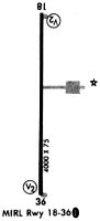
| Runway 18/36 | 5905 ft x 75 ft (1800 m x 23 m) | |
| Runway Length Source: | STATE as of 12/30/2005 | |
| Surface: | Asphalt - Good condition - No special surface treatment | |
| Runway Edge Lights: | Medium Intensity | |
Runway 18 |
Runway 36 |
|
Elevation: |
733.7 | 715.2 |
Latitude: |
39-59-36.5869N | 39-58-38.2316N |
Longitude: |
090-48-14.2861W | 090-48-15.5197W |
|
Runway True Alignment: |
181 | 001 |
Glide Path Angle: |
3.0 degrees | 3.0 degrees |
Runway Markings Type: |
Nonprecision Instrument | Nonprecision Instrument |
Runway Markings Condition: |
Fair | Fair |
Object at End: |
POLE | |
Object Height: |
44 | |
Object Marked/Lighted?: |
Marked | |
Distance from End: |
1577 | |
Object Centerline Offset: |
255 ft. left of centerline | |
Visual Glide Slope Indicators: |
4-Light PAPI On Left Side Of Runway | 4-Light PAPI On Left Side Of Runway |
Threshold Crossing Height: |
43 | 42 |
Services
Airframe Repair: |
Major |
Powerplant Repair: |
Major |
Bottled Oxygen: |
None |
Bulk Oxygen: |
None |
Fuel Available: |
100LL, Jet A |
Landing Fees: |
No |
Parking: |
Hangars and tiedowns available |
Maps & Diagrams
I63 Sectional
Flight Planning
at skyvector.com
at skyvector.com