Location
Latitude: |
39-27-02.2750N (39.450632) |
Longitude: |
087-18-25.1640W (-87.30699) |
Elevation: |
589.2 feet MSL (180 m MSL) |
Magnetic Variation: |
4.1 W (as of April 2024 from WMM2020 model) |
Time Zone: |
UTC -5.0 (Standard Time) UTC -4.0 (Daylight Savings Time) |
From City: |
05 N.M. E of Terre Haute, Indiana |
Found On: |
St Louis Chart |
FAA Region: |
AGL |
Contacts
Manager: |
Publicly owned: |
| JEFF HAUSER 581 S. AIRPORT ST. TERRE HAUTE, IN 47803 812-877-2524 |
TERRE HAUTE RGNL ARPT AUTH 581 S. AIRPORT ST. TERRE HAUTE, IN 47803 812-877-2524 |
Operations
Airport Status: |
Operational |
Facility Use: |
Public |
Type: |
Airport |
Activation Date: |
12/1944 |
Control tower: |
Yes |
Attendance (Months/Days/Hours): |
Months/Days/Hours ALL/ALL/ALL |
Boundary ARTCC: |
ZID (Indianapolis) |
Responsible ARTCC: |
ZID (Indianapolis) |
Segmented Circle Indicator: |
No |
Traffic Pattern Altitude (MSL): |
1589 feet (484 m) |
NOTAMs Facility: |
HUF |
NOTAM-D Service: |
Yes |
International Airport of Entry: |
No |
Customs Landing Rights: |
No |
Military Landing Rights: |
Yes |
Civil/Military Joint Use: |
No |
Aircraft Rescue and Firefighting: |
Class IV ARFF Index: A Air Carrier Service: Not Scheduled Certification Date: 05/1973 |
Based Aircraft
| Single Engine: | 70 |
| Multi Engine: | 7 |
| Jet Engine: | 1 |
| Gliders: | 1 |
Annual Operations (as of 12/31/2022)
| Total Operations: | 72639 | |
| Commercial: | 26 | 0.0% |
| Air Taxi: | 2701 | 3.7% |
| GA Local: | 41021 | 56.5% |
| GA Itinerant: | 28299 | 39.0% |
| Military Aircraft: | 592 | 0.8% |
Communications
| Unicom: | 122.950 |
| Tower: | HULMAN 134.725 322.475 Hrs: 24 |
| Ground: | 121.6 348.6 |
| Approach: | HULMAN 125.45 339.8 Hrs: 24 119.8 263.125 |
| Departure: | HULMAN 125.45 339.8 Hrs: 24 119.8 263.125 |
| ATIS: | 127.5 269.375 Hrs: 24 |
| ASOS: | 127.5 (812-877-7010) |
| EMERG: | 243.0 |
Fixed Based Operators (FBOs) & Fuel
(Click on a business for detail)
Please help us keep this information up to date. This is a FREE SERVICE just like everything else on Airport Guide! If you see that a business needs to be added, modified, or deleted please fill out our Update Form.
To add, modify, or delete a business click here.
Please help us keep this information up to date. This is a FREE SERVICE just like everything else on Airport Guide! If you see that a business needs to be added, modified, or deleted please fill out our Update Form.
Area Code: 812 |
| Business Name | Frequency | Phone | Fuel Grade |
|---|---|---|---|
| Mills Aviation, Inc.
Update FBO info |
Unicom 122.95 | 877-2507 | 100LL, Jet A |
Flight Service Stations
| Primary | Alternate | |
| FSS on Field: | N | |
| FSS Name (ID): | Terre Haute(HUF) | |
| Frequency: | ||
| Toll Free Phone: | 1-800-WX-BRIEF |
Instrument Procedures / Charts
FAA Terminal Procedures valid from 0901Z 03/21/24 to 0901Z 04/18/24.
There are various types of charts available for an airport. They are listed in the Page Type column. Here is a legend for those types:
APD - Airport Diagram
DP - Departure Procedure Charts
HOT - Hot Spots
IAP - Instrument Approach Procedure Charts
MIN - Minimums
STAR - Standard Terminal Arrival Charts
| Page Type | Page Name | Volume | Action Since Last Cycle |
|---|---|---|---|
| APD | AIRPORT DIAGRAM | EC-2 | |
| IAP | ILS OR LOC RWY 05 | EC-2 | |
| IAP | RNAV (GPS) RWY 05 | EC-2 | |
| IAP | RNAV (GPS) RWY 14 | EC-2 | |
| IAP | RNAV (GPS) RWY 23 | EC-2 | |
| IAP | RNAV (GPS) RWY 32 | EC-2 | |
| IAP | VOR RWY 05 | EC-2 | |
| LAH | LAHSO | EC-2 | |
| MIN | ALTERNATE MINIMUMS | EC-2 | |
| MIN | RADAR MINIMUMS | EC-2 | |
| MIN | TAKEOFF MINIMUMS | EC-2 |
Terminal Procedures are only available for airports in several countries with more being added all the time. If you are looking for a specific country's charts, please send an email to support(at)airportguide.com stating the country name. This will be used to prioritize the implementation.
Navigation Aids (Navaids) near HUF
| Dist (NM) | ID | Morse Code | Name | Type | Freq | True Hdg | Mag Hdg |
|---|---|---|---|---|---|---|---|
| 3.5 | TTH | _ _ . . . . | Terre Haute | VORTAC | 115.30 | 49 | 53 |
| 5.6 | HU | . . . . . . _ | Yinno | NDB | 245 | 228 | 232 |
| 21.2 | SIV | . . . . . . . . _ | Sullivan | NDB | 326 | 197 | 201 |
| 28.0 | TVX | _ . . . _ _ . . _ | Greencastle | NDB | 521 | 55 | 59 |
| 30.5 | RSV | . _ . . . . . . . _ | Robinson | VOR-DME | 108.40 | 211 | 215 |
| 30.5 | PLX | . _ _ . . _ . . _ . . _ | Palestine | NDB | 391 | 210 | 214 |
| 33.4 | CZB | _ . _ . _ _ . . _ . . . | Casey | NDB | 359 | 255 | 259 |
| 36.6 | CFJ | _ . _ . . . _ . . _ _ _ | Crawfordsville | NDB | 388 | 29 | 33 |
| 37.1 | OOM | _ _ _ _ _ _ _ _ | Hoosier | VORTAC | 110.20 | 119 | 123 |
| 40.2 | MT | _ _ _ | Zebre | NDB | 347 | 269 | 273 |
| 43.1 | LWV | . _ . . . _ _ . . . _ | Lawrenceville | DME | 108.8 | 198 | 202 |
| 45.4 | MTO | _ _ _ _ _ _ | Mattoon | DME | 109.4 | 272 | 276 |
| 45.6 | HMJ | . . . . _ _ . _ _ _ | Homer | NDB | 281 | 319 | 323 |
| 47.0 | OEA | _ _ _ . . _ | Vincennes | NDB | 251 | 194 | 198 |
| 48.6 | VHP | . . . _ . . . . . _ _ . | Brickyard | VORTAC | 116.30 | 62 | 66 |
| 49.2 | IND | . . _ . _ . . | Indianapolis Intl | VOT | 109.60 | 69 | 74 |
| 50.9 | CM | _ . _ . _ _ | Veals | NDB | 407 | 307 | 311 |
| 51.4 | DN | _ . . _ . | Julip | NDB | 332 | 348 | 352 |
| 51.9 | DNV | _ . . _ . . . . _ | Danville | VORTAC | 111.00 | 347 | 351 |
| 54.6 | BFR | _ . . . . . _ . . _ . | Bedford | NDB | 344 | 131 | 135 |
Nearby Airports with Fuel
Notices to Airmen (NOTAMS)
Remarks
| A110-3 | BIRDS ON & INVOF ARPT. |
| A110-9 | ACFT SVCS AVBL 2200 & 0600 SUBJECT TO AFTER-HRS CALLOUT FEE. |
| A24 | LNDG FEE FOR CIVILIAN ACFT OVER 12,500 LBS. |
| A26 | CLSD TO SKED ACR OPS GTR THAN 9 PSGR SEATS. UNSKED ACR OPS GTR THAN 30 PSGR SEATS RQR PPR - CTC 812-877-2524 OR 812-877-2252. INDEX B ARFF CAPABILITY AVBL ON REQ. |
| A31-05/23 | 1000 FT PAVED BLAST PAD SW END & 1325 FT PAVED BLAST PAD NE END; RY 32 400 FT BY 150 FT BLAST PAD; NOT AVBL FOR ASDA. |
| E80 | US CUSTOMS USER FEE ARPT. |
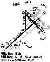
Runways
Runway Summary
| Runways: | 05/23 14/32 |
| Longest Runway: | 05/23 is 9021 ft (2750 m) long |
| Runways with an Instrument Approach: | 05 |
HUF Airport Runway Details
| Runway 05/23 | 9021 ft x 150 ft (2750 m x 46 m) | |
| Runway Length Source: | 3RD PARTY SURVEY as of 11/02/2018 | |
| Surface: | Asphalt - Fair condition - Saw-cut or plastic grooved | |
| Runway Pavement Class: | 49 /R/C/W/U | |
| Runway Edge Lights: | High Intensity | |
Runway Weight Bearing Capacity (in thousands of pounds) |
||
| Single Wheel Landing Gear: | 75.0 | |
| Dual Wheel Landing Gear: | 200.0 | |
| Dual Tandem Wheel Landing Gear: | 300.0 | |
| Dual Dual Tandem Wheel Landing Gear: | 600.0 | |
Runway 05 |
Runway 23 |
|
Elevation: |
572.3 | 582.2 |
Latitude: |
39-26-25.8718N | 39-27-26.4377N |
Longitude: |
087-19-23.3687W | 087-17-58.9882W |
|
Runway True Alignment: |
047 | 227 |
ILS Type: |
ILS | |
Glide Path Angle: |
3.0 degrees | 3.0 degrees |
Traffic Pattern: |
Left | Left |
Runway Markings Type: |
Precision Instrument | Precision Instrument |
Runway Markings Condition: |
Fair | Fair |
Object at End: |
STACK | TREE |
Object Height: |
54 | 71 |
Distance from End: |
2841 | 2297 |
Object Centerline Offset: |
412 ft. left of centerline | 535 ft. right of centerline |
Visual Glide Slope Indicators: |
4-Light PAPI On Left Side Of Runway | 4-Light PAPI On Left Side Of Runway |
Runway Visual Range (RVR): |
Touchdown | Rollout |
Approach Light System: |
1,400 Foot Medium Intensity Approach Lighting System With Runway Alignment Indicator Lights | |
REIL: |
No | Yes |
Touchdown Lights: |
No | No |
Centerline Lights: |
No | No |
Threshold Crossing Height: |
40 | 50 |
Declared Distances |
||
Take Off Run Avbl. (TORA): |
9020 | 9020 |
Take Off Distance Avbl. (TODA): |
9020 | 9020 |
Actual Stop Dist. Avbl. (ASDA): |
9020 | 9020 |
Landing Dist. Avbl. (LDA): |
9020 | 9020 |
| Runway 14/32 | 7200 ft x 150 ft (2195 m x 46 m) | |
| Runway Length Source: | 3RD PARTY SURVEY as of 11/12/2012 | |
| Surface: | Asphalt - Fair condition - Saw-cut or plastic grooved | |
| Runway Pavement Class: | 42 /F/C/X/U | |
| Runway Edge Lights: | High Intensity | |
Runway Weight Bearing Capacity (in thousands of pounds) |
||
| Single Wheel Landing Gear: | 75.0 | |
| Dual Wheel Landing Gear: | 200.0 | |
| Dual Tandem Wheel Landing Gear: | 300.0 | |
Runway 14 |
Runway 32 |
|
Elevation: |
568.0 | 589.1 |
Latitude: |
39-27-35.0594N | 39-26-44.8164N |
Longitude: |
087-18-37.5995W | 087-17-32.5983W |
|
Runway True Alignment: |
135 | 315 |
Glide Path Angle: |
2.8 degrees | 3.0 degrees |
Traffic Pattern: |
Left | Left |
Runway Markings Type: |
Nonprecision Instrument | Nonprecision Instrument |
Runway Markings Condition: |
Good | Good |
Object at End: |
TREE | |
Object Height: |
105 | |
Distance from End: |
2597 | |
Object Centerline Offset: |
412 ft. left of centerline | 535 ft. right of centerline |
Visual Glide Slope Indicators: |
4-Light PAPI On Left Side Of Runway | 4-Light PAPI On Left Side Of Runway |
REIL: |
Yes | Yes |
Touchdown Lights: |
No | No |
Centerline Lights: |
No | No |
Threshold Crossing Height: |
59 | 84 |
Declared Distances |
||
Take Off Run Avbl. (TORA): |
7200 | 7200 |
Take Off Distance Avbl. (TODA): |
7200 | 7200 |
Actual Stop Dist. Avbl. (ASDA): |
7200 | 7200 |
Landing Dist. Avbl. (LDA): |
7200 | 7200 |
Services
Airframe Repair: |
None |
Powerplant Repair: |
None |
Bottled Oxygen: |
None |
Bulk Oxygen: |
None |
Fuel Available: |
100LL, Jet A |
Landing Fees: |
No |
Parking: |
Hangars and tiedowns available |
Maps & Diagrams
HUF Sectional
Flight Planning
at skyvector.com
at skyvector.com