Location
Latitude: |
35-13-58.1000N (35.232806) |
Longitude: |
075-37-04.1000W (-75.617806) |
Elevation: |
16.3 feet MSL (5 m MSL) |
Magnetic Variation: |
10.9 W (as of April 2024 from WMM2020 model) |
Time Zone: |
UTC -5.0 (Standard Time) UTC -4.0 (Daylight Savings Time) |
From City: |
04 N.M. E of Hatteras, North Carolina |
Found On: |
Charlotte Chart |
FAA Region: |
ASO |
Contacts
Manager: |
Publicly owned: |
| BOONE VANDZURA 1401 NATIONAL PARK DRIVE MANTEO, NC 27954 252-475-9000 |
NATIONAL PARK SERVICE 1401 NATIONAL PARK DR MANTEO, NC 27954 252-475-9000 |
Operations
Airport Status: |
Operational |
Facility Use: |
Public |
Type: |
Airport |
Activation Date: |
04/1960 |
Control tower: |
No |
Attendance (Months/Days/Hours): |
Months/Days/Hours Unattended |
Boundary ARTCC: |
ZDC (Washington) |
Responsible ARTCC: |
ZDC (Washington) |
Segmented Circle Indicator: |
Yes |
Traffic Pattern Altitude (MSL): |
1016 feet (310 m) |
NOTAMs Facility: |
HSE |
NOTAM-D Service: |
Yes |
International Airport of Entry: |
No |
Customs Landing Rights: |
No |
Military Landing Rights: |
No |
Civil/Military Joint Use: |
No |
Based Aircraft
Annual Operations (as of 09/02/2022)
| Total Operations: | 9200 | |
| Air Taxi: | 100 | 1.1% |
| GA Local: | 4000 | 43.5% |
| GA Itinerant: | 5000 | 54.3% |
| Military Aircraft: | 100 | 1.1% |
Communications
| CTAF: | 122.900 |
| Approach: | CHERRY POINT 119.75 119.75 |
| Departure: | CHERRY POINT 119.75 119.75 |
| ASOS: | 118.375 (252-995-3646) |
- COMMUNICATIONS PRVDD BY RALEIGH RADIO ON FREQ 122.3 (HATTERAS RCO).
Fixed Based Operators (FBOs) & Fuel
(Click on a business for detail)
Please help us keep this information up to date. This is a FREE SERVICE just like everything else on Airport Guide! If you see that a business needs to be added, modified, or deleted please fill out our Update Form.
To add, modify, or delete a business click here.
Please help us keep this information up to date. This is a FREE SERVICE just like everything else on Airport Guide! If you see that a business needs to be added, modified, or deleted please fill out our Update Form.
Area Code: 252 |
| Business Name | Frequency | Phone | Fuel Grade |
|---|
Flight Service Stations
| Primary | Alternate | |
| FSS on Field: | N | |
| FSS Name (ID): | Raleigh(RDU) | |
| Frequency: | ||
| Toll Free Phone: | 1-800-WX-BRIEF |
Instrument Procedures / Charts
FAA Terminal Procedures valid from 0901Z 03/21/24 to 0901Z 04/18/24.
There are various types of charts available for an airport. They are listed in the Page Type column. Here is a legend for those types:
APD - Airport Diagram
DP - Departure Procedure Charts
HOT - Hot Spots
IAP - Instrument Approach Procedure Charts
MIN - Minimums
STAR - Standard Terminal Arrival Charts
| Page Type | Page Name | Volume | Action Since Last Cycle |
|---|---|---|---|
| IAP | RNAV (GPS) RWY 07 | SE-2 | |
| IAP | RNAV (GPS) RWY 25 | SE-2 | |
| MIN | TAKEOFF MINIMUMS | SE-2 |
Terminal Procedures are only available for airports in several countries with more being added all the time. If you are looking for a specific country's charts, please send an email to support(at)airportguide.com stating the country name. This will be used to prioritize the implementation.
Navigation Aids (Navaids) near HNC
| Dist (NM) | ID | Morse Code | Name | Type | Freq | True Hdg | Mag Hdg |
|---|---|---|---|---|---|---|---|
| 19.4 | OUC | _ _ _ . . _ _ . _ . | Pamlico/Dcmsnd | NDB-DME | 404 | 249 | 260 |
| 41.1 | MQI | _ _ _ _ . _ . . | Manteo | NDB | 370 | 354 | 365 |
| 41.4 | RBX | . _ . _ . . . _ . . _ | Wright Brothers | VOR-DME | 111.60 | 354 | 365 |
| 59.5 | MRH | _ _ . _ . . . . . | Morehead | NDB | 269 | 239 | 250 |
| 64.8 | NKT | _ . _ . _ _ | Cherry Point | TACAN | 112.80 | 252 | 263 |
| 66.4 | EDE | . _ . . . | Edenton | NDB | 265 | 316 | 327 |
| 67.2 | ECG | . _ . _ . _ _ . | Elizabeth City | VOR-DME | 112.50 | 336 | 347 |
| 70.1 | LLW | . _ . . . _ . . . _ _ | Woodville | NDB | 254 | 332 | 343 |
| 70.7 | EWN | . . _ _ _ . | New Bern | VOR-DME | 113.60 | 262 | 273 |
| 72.8 | EW | . . _ _ | Katfi | NDB | 362 | 260 | 271 |
| 74.7 | RNW | . _ . _ . . _ _ | Chocowinity | NDB | 388 | 283 | 294 |
| 84.9 | MCZ | _ _ _ . _ . _ _ . . | Williamston | NDB | 336 | 296 | 307 |
| 89.7 | PGV | . _ _ . _ _ . . . . _ | Belvoir | FAN MARKER | 286 | 297 | |
| 90.0 | EY | . _ . _ _ | Chesi | NDB | 233 | 335 | 346 |
| 90.3 | AQE | . _ _ _ . _ . | Alwood | NDB | 230 | 288 | 299 |
| 91.7 | CVI | _ . _ . . . . _ . . | Cofield | VORTAC | 114.60 | 318 | 329 |
| 95.0 | NCA | _ . _ . _ . . _ | New River | TACAN | 115.40 | 251 | 261 |
| 95.4 | ISO | . . . . . _ _ _ | Kinston | VORTAC | 117.50 | 275 | 285 |
| 96.1 | RK | . _ . _ . _ | Waley | NDB | 249 | 328 | 339 |
| 97.6 | NTU | _ . _ . . _ | Oceana | TACAN | 116.60 | 348 | 359 |
Nearby Airports with Fuel
| Dist (NM) | Name (Airport IDs) | True Hdg | Mag Hdg | Fuel Grade |
|---|---|---|---|---|
| 41.3 | Dare County Regional Airport (MEO KMQI MQI) |
354 | 365 | 100LL, Jet A-1+ |
| 59.4 | Michael J Smith Field Airport (KMRH MRH) |
240 | 250 | 100LL, Jet A-1+ |
| 66.6 | Northeastern Regional Airport (EDE KEDE EDE) |
316 | 327 | 100LL, Jet A-1+ |
| 67.4 | Elizabeth City Cg Air Station/Regional Airport (ECG KECG ECG) |
336 | 347 | 100LL, Jet A-1+ |
| 70.6 | Coastal Carolina Regional Airport (EWN KEWN EWN) |
262 | 272 | 100LL, Jet A |
| 89.7 | Pitt-Greenville Airport (PGV KPGV PGV) |
286 | 296 | 100LL, Jet A |
| 92.5 | Chesapeake Regional Airport (KCPK CPK) |
338 | 349 | 100LL, Jet A |
| 97.7 | Kinston Regional Jetport At Stallings Field Airport (ISO KISO ISO) |
274 | 284 | 100LL, Jet A |
| 99.0 | Tri-County At Henry Joyner Field Airport (KASJ ASJ) |
310 | 320 | 100LL, Jet A-1+ |
| 99.2 | Suffolk Exec Airport (KSFQ SFQ) |
331 | 342 | 100LL, Jet A, MOGAS |
Notices to Airmen (NOTAMS)
Remarks
| A11 | ARPT UNDER LEASE TO NC DOT UNDER SPECIAL-USE PERMIT; CTC NR 919-814-0550. |
| A110-1 | +10-35 FT SAND DUNES AND SCRUB TREES BOTH SIDES OF RWY WITHIN ROFA. |
| A110-2 | ARPT CLSD 30 MIN AFTER SS TIL 30 MIN BEFORE SR. ALL NIGHTTIME OPNS PROHIBITED. |
| A110-3 | HIGH SPEED LOW LEVEL MIL OPNS IN VIC OF ARPT. |
| A110-4 | FLOCKS OF SEAGULLS ON & INVOF OF ARPT. |
| A110-5 | RWY 07/25 SAFETY AREA IS LOOSE SAND & DUNES - NOT SUITABLE FOR ACFT. |
| A110-6 | ADDITIONAL ACFT PARKING AVBL ON MID-FIELD APRON. |
| A110-7 | ARPT LCTD IN CAPE HATTERAS NTL SEASHORE. MNTN 2000 FT VER & HORIZONTAL DIST FM SEASHORE BEACHES. |
| A110-8 | FOR CD CTC CHERRY POINT APCH AT 252-466-5960. |
| A16 | NTL PARKS SVC NR ANSWERED 7 DAYS A WEEK BTWN 0800 TO 1700. |
| A58-07 | 11 FT SAND DUNES 38 FT FM THR 108 FT R OF CNTRLN, AND 11 FT SAND DUNES 0-200 FT FM THR 108 FT L OF CNTRLN. |
| A58-25 | 8 FT DUNE 57 FT FM THR 117 FT L OF CNTRLN; 15 FT WINDSOCK 72 FT FM THR 221 FT L OF CNTRLN; AND 28 FT TREES 0-100 FT FM THR 159 FT R OF CNTRLN. |
Runways
Runway Summary
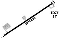
| Runways: | 07/25 |
| Longest Runway: | 07/25 is 3002 ft (915 m) long |
| Runways with an Instrument Approach: |
HNC Airport Runway Details
| Runway 07/25 | 3002 ft x 75 ft (915 m x 23 m) | |
| Runway Length Source: | 3RD PARTY SURVEY as of 08/04/2013 | |
| Surface: | Asphalt - Fair condition - No special surface treatment | |
Runway Weight Bearing Capacity (in thousands of pounds) |
||
| Single Wheel Landing Gear: | 30.0 | |
Runway 07 |
Runway 25 |
|
Elevation: |
8.6 | 16.1 |
Latitude: |
35-13-49.9075N | 35-14-06.2024N |
Longitude: |
075-37-19.1847W | 075-36-48.9306W |
|
Runway True Alignment: |
057 | 237 |
Glide Path Angle: |
0.0 degrees | 0.0 degrees |
Traffic Pattern: |
Left | Left |
Runway Markings Type: |
Nonprecision Instrument | Nonprecision Instrument |
Runway Markings Condition: |
Fair | Fair |
Object at End: |
BRUSH | TREE |
Object Height: |
14 | 29 |
Distance from End: |
399 | 277 |
Object Centerline Offset: |
154 ft. left of centerline | 145 ft. right of centerline |
Services
Airframe Repair: |
Major |
Powerplant Repair: |
Major |
Bottled Oxygen: |
None |
Bulk Oxygen: |
None |
Fuel Available: |
100LL, Jet A, MOGAS |
Landing Fees: |
No |
Parking: |
Tiedowns available |
Other Services: |
Decker Aviation, LLC does not handle fuel sales. Fuel sales are provided by the City of Suffolk. |
Maps & Diagrams
HNC Sectional
Flight Planning
at skyvector.com
at skyvector.com