Location
Latitude: |
31-36-49.1800N (31.613661) |
Longitude: |
091-17-50.4080W (-91.297336) |
Elevation: |
272.4 feet MSL (83 m MSL) |
Magnetic Variation: |
0.7 W (as of April 2024 from WMM2020 model) |
Time Zone: |
UTC -6.0 (Standard Time) UTC -5.0 (Daylight Savings Time) |
From City: |
06 N.M. NE of Natchez, Mississippi |
Found On: |
Houston Chart |
FAA Region: |
ASO |
Contacts
Manager: |
Publicly owned: |
| RICHARD NELSON 434 AIRPORT RD NATCHEZ, MS 39120 601-442-5171 |
ADAMS COUNTY BOX 1008 NATCHEZ, MS 39121 601-442-2431 |
Operations
Airport Status: |
Operational |
Facility Use: |
Public |
Type: |
Airport |
Activation Date: |
12/1944 |
Control tower: |
No |
Attendance (Months/Days/Hours): |
Months/Days/Hours ALL/ALL/0600-2000 |
Boundary ARTCC: |
ZHU (Houston) |
Responsible ARTCC: |
ZHU (Houston) |
Lighting Schedule: |
SEE RMK |
Segmented Circle Indicator: |
Yes |
Traffic Pattern Altitude (MSL): |
1272 feet (388 m) |
NOTAMs Facility: |
HEZ |
NOTAM-D Service: |
Yes |
International Airport of Entry: |
No |
Customs Landing Rights: |
No |
Military Landing Rights: |
Yes |
Civil/Military Joint Use: |
No |
Aircraft Rescue and Firefighting: |
Class IV ARFF Index: A Air Carrier Service: Not Scheduled Certification Date: 06/1993 |
Based Aircraft
| Single Engine: | 21 |
| Multi Engine: | 1 |
| Jet Engine: | 1 |
| GA Helicopters: | 1 |
Annual Operations (as of 07/31/2021)
| Total Operations: | 15142 | |
| Air Taxi: | 641 | 4.2% |
| GA Local: | 6000 | 39.6% |
| GA Itinerant: | 8197 | 54.1% |
| Military Aircraft: | 304 | 2.0% |
Communications
| CTAF: | 122.800 |
| Unicom: | 122.800 |
| AWOS-3PT: | 124.675 (601-446-8022) |
- APCH/DEP SVC PRVDD BY HOUSTON ARTCC (ZHU) ON FREQS 120.975/299.6 (NATCHEZ RCAG).
Fixed Based Operators (FBOs) & Fuel
(Click on a business for detail)
Please help us keep this information up to date. This is a FREE SERVICE just like everything else on Airport Guide! If you see that a business needs to be added, modified, or deleted please fill out our Update Form.
To add, modify, or delete a business click here.
Please help us keep this information up to date. This is a FREE SERVICE just like everything else on Airport Guide! If you see that a business needs to be added, modified, or deleted please fill out our Update Form.
Area Code: 601 |
| Business Name | Frequency | Phone | Fuel Grade |
|---|---|---|---|
| Airport Operations
Update FBO info |
Unicom 122.8 | 442-3142 | 100LL, Jet A |
Flight Service Stations
| Primary | Alternate | |
| FSS on Field: | N | |
| FSS Name (ID): | Greenwood(GWO) | |
| Frequency: | ||
| Toll Free Phone: | 1-800-WX-BRIEF |
Instrument Procedures / Charts
FAA Terminal Procedures valid from 0901Z 03/21/24 to 0901Z 04/18/24.
There are various types of charts available for an airport. They are listed in the Page Type column. Here is a legend for those types:
APD - Airport Diagram
DP - Departure Procedure Charts
HOT - Hot Spots
IAP - Instrument Approach Procedure Charts
MIN - Minimums
STAR - Standard Terminal Arrival Charts
| Page Type | Page Name | Volume | Action Since Last Cycle |
|---|---|---|---|
| IAP | ILS OR LOC RWY 14 | SC-4 | |
| IAP | RNAV (GPS) RWY 14 | SC-4 | |
| IAP | RNAV (GPS) RWY 18 | SC-4 | |
| IAP | RNAV (GPS) RWY 32 | SC-4 | |
| IAP | RNAV (GPS) RWY 36 | SC-4 | |
| MIN | ALTERNATE MINIMUMS | SC-4 | |
| MIN | TAKEOFF MINIMUMS | SC-4 |
Terminal Procedures are only available for airports in several countries with more being added all the time. If you are looking for a specific country's charts, please send an email to support(at)airportguide.com stating the country name. This will be used to prioritize the implementation.
Navigation Aids (Navaids) near HEZ
| Dist (NM) | ID | Morse Code | Name | Type | Freq | True Hdg | Mag Hdg |
|---|---|---|---|---|---|---|---|
| 0.3 | HEZ | . . . . . _ _ . . | Natchez | VOR-DME | 110.00 | 336 | 337 |
| 4.6 | HAH | . . . . . _ . . . . | Natchez-Adams County | NDB | 388 | 2 | 3 |
| 40.3 | TKH | _ _ . _ . . . . | Tallulah | NDB | 344 | 19 | 20 |
| 45.7 | MC | _ _ _ . _ . | Ferni | NDB | 413 | 117 | 118 |
| 50.5 | MKV | _ _ _ . _ . . . _ | Marksville | NDB | 347 | 232 | 232 |
| 53.6 | MRK | _ _ . _ . _ . _ | Molly Ridge | NDB | 338 | 333 | 334 |
| 56.3 | MCB | _ _ _ . _ . _ . . . | Mc Comb | VORTAC | 116.70 | 108 | 109 |
| 59.7 | FWX | . . _ . . _ _ _ . . _ | New Roads | NDB | 356 | 189 | 190 |
| 61.1 | RYB | . _ . _ . _ _ _ . . . | Raymond | NDB | 375 | 47 | 48 |
| 62.0 | BT | _ . . . _ | Rundi | NDB | 284 | 175 | 176 |
| 65.0 | ML | _ _ . _ . . | Sabar | NDB | 392 | 321 | 322 |
| 65.2 | AEX | . _ . _ . . _ | Alexandria | VORTAC | 116.10 | 251 | 251 |
| 65.8 | BWK | _ . . . . _ _ _ . _ | Bunkie | NDB | 397 | 227 | 227 |
| 65.9 | MLU | _ _ . _ . . . . _ | Monroe | VORTAC | 117.20 | 325 | 326 |
| 67.7 | LSU | . _ . . . . . . . _ | Fighting Tiger | VORTAC | 116.50 | 179 | 180 |
| 70.7 | OPL | _ _ _ . _ _ . . _ . . | St Landry | NDB | 335 | 215 | 215 |
| 71.3 | JH | . _ _ _ . . . . | Brenz | NDB | 260 | 47 | 48 |
| 73.2 | BLE | _ . . . . _ . . . | Lake Providence | NDB | 278 | 4 | 5 |
| 73.6 | SWB | . . . . _ _ _ . . . | Sawmill | VOR-DME | 113.75 | 287 | 287 |
| 74.7 | BQP | _ . . . _ _ . _ . _ _ . | Bastrop | NDB | 329 | 336 | 337 |
Nearby Airports with Fuel
Notices to Airmen (NOTAMS)
Remarks
| A110-1 | GND PWR UNIT AVBL ON FLD. |
| A110-2 | DEER ON & INVOF RWYS. |
| A110-3 | TWY A & C1 NOT AVBL FOR ACR USE. |
| A26 | CLSD TO UNSKED ACR OPS WITH MORE THAN 30 PAX SEATS EXCP 48 HR PPR CALL AMGR. |
| A30-18/36 | RWY 18/36 NOT AVBL FOR SKEDD ACR OPS WITH MORE THAN 9 PAX SEATS OR UNSKED ACR OPS WITH AT LEAST 31 PAX SEATS. |
| A33-14/32 | UNEVEN PAVEMENT. |
| A33-18/36 | WIDESPREAD CRACKING & UNEVEN PAVEMENT. |
| A42-14 | MARKINGS OBSCURED. |
| A42-18 | MARKINGS FADED. |
| A42-32 | MARKINGS OBSCURED. |
| A42-36 | MARKINGS FADED. |
| A81-APT | ACTVT MALSR RWY 14; PAPI RWY 14 & 32; VASI RWY 18; MIRL RWY 18/36 - CTAF. |
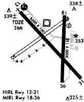
Runways
Runway Summary
| Runways: | 14/32 18/36 |
| Longest Runway: | 14/32 is 6500 ft (1981 m) long |
| Runways with an Instrument Approach: | 14 |
HEZ Airport Runway Details
| Runway 14/32 | 6500 ft x 150 ft (1981 m x 46 m) | |
| Runway Length Source: | 3RD PARTY SURVEY as of 01/08/2019 | |
| Surface: | Asphalt - Poor condition - Saw-cut or plastic grooved | |
| Runway Pavement Class: | 39 /F/B/Y/T | |
| Runway Edge Lights: | High Intensity | |
Runway Weight Bearing Capacity (in thousands of pounds) |
||
| Single Wheel Landing Gear: | 50.0 | |
| Dual Wheel Landing Gear: | 78.0 | |
| Dual Tandem Wheel Landing Gear: | 172.0 | |
Runway 14 |
Runway 32 |
|
Elevation: |
261.5 | 269.3 |
Latitude: |
31-37-14.0822N | 31-36-27.5569N |
Longitude: |
091-18-21.2348W | 091-17-29.3267W |
|
Runway True Alignment: |
136 | 316 |
ILS Type: |
ILS | |
Glide Path Angle: |
3.0 degrees | 3.0 degrees |
Traffic Pattern: |
Left | Left |
Runway Markings Type: |
Precision Instrument | Nonprecision Instrument |
Runway Markings Condition: |
Fair | Fair |
Object at End: |
TREES | |
Object Height: |
78 | |
Distance from End: |
2400 | |
Object Centerline Offset: |
250 ft. right of centerline | |
Visual Glide Slope Indicators: |
4-Light PAPI On Right Side Of Runway | 4-Light PAPI On Left Side Of Runway |
Approach Light System: |
1,400 Foot Medium Intensity Approach Lighting System With Runway Alignment Indicator Lights | |
Threshold Crossing Height: |
55 | 43 |
| Runway 18/36 | 5000 ft x 150 ft (1524 m x 46 m) | |
| Runway Length Source: | 3RD PARTY SURVEY as of 01/08/2019 | |
| Surface: | Asphalt - Poor condition - No special surface treatment | |
| Runway Pavement Class: | 35 /F/B/Y/T | |
| Runway Edge Lights: | Medium Intensity | |
Runway Weight Bearing Capacity (in thousands of pounds) |
||
| Single Wheel Landing Gear: | 83.0 | |
| Dual Wheel Landing Gear: | 113.0 | |
| Dual Tandem Wheel Landing Gear: | 65.0 | |
Runway 18 |
Runway 36 |
|
Elevation: |
269.4 | 260.2 |
Latitude: |
31-37-11.7834N | 31-36-22.3095N |
Longitude: |
091-17-43.6461W | 091-17-44.5055W |
|
Runway True Alignment: |
181 | 001 |
Glide Path Angle: |
3.0 degrees | 0.0 degrees |
Traffic Pattern: |
Left | Left |
Runway Markings Type: |
Nonprecision Instrument | Nonprecision Instrument |
Runway Markings Condition: |
Poor | Poor |
Object at End: |
TREES | |
Object Height: |
63 | |
Distance from End: |
1400 | |
Object Centerline Offset: |
250 ft. right of centerline | |
Visual Glide Slope Indicators: |
4-Box VASI On Left Side Of Runway | |
Threshold Crossing Height: |
30 |
Services
Airframe Repair: |
Major |
Powerplant Repair: |
Major |
Bottled Oxygen: |
None |
Bulk Oxygen: |
None |
Fuel Available: |
100LL, Jet A |
Landing Fees: |
No |
Parking: |
Hangars and tiedowns available |
Maps & Diagrams
HEZ Sectional
Flight Planning
at skyvector.com
at skyvector.com