
Location
Latitude: |
53-37-49.4458N (53.630402) |
Longitude: |
009-59-17.6271E (9.98823) |
Elevation: |
53 feet MSL (16 m MSL) |
Magnetic Variation: |
4 E (as of April 2024 from WMM2020 model) |
Time Zone: |
UTC +1.0 (Standard Time) UTC +2.0 (Daylight Savings Time) |
Contacts
Manager: |
: |
Operations
Airport Status: |
Operational |
Facility Use: |
Public |
Type: |
Airport |
Traffic Pattern Altitude (MSL): |
1053 feet (321 m) |
Based Aircraft
Annual Operations (as of )
Communications
| LANGEN INFORMATION: | 125.1 |
| TWR: | 126.85 |
| GND: | 121.8 |
| APRON: | 121.7 |
| BREMEN RADAR: | 134.25 |
| ATIS: | 123.125 |
| DIRECTOR: | 118.2 |
Fixed Based Operators (FBOs) & Fuel
(Click on a business for detail)
Please help us keep this information up to date. This is a FREE SERVICE just like everything else on Airport Guide! If you see that a business needs to be added, modified, or deleted please fill out our Update Form.
To add, modify, or delete a business click here.
Please help us keep this information up to date. This is a FREE SERVICE just like everything else on Airport Guide! If you see that a business needs to be added, modified, or deleted please fill out our Update Form.
| Business Name | Frequency | Phone | Fuel Grade |
|---|
Flight Service Stations
| Primary | Alternate | |
| FSS on Field: | ||
| FSS Name (ID): | ||
| Frequency: | ||
| Toll Free Phone: |
Instrument Procedures / Charts
Terminal Procedures are only available for airports in several countries with more being added all the time. If you are looking for a specific country's charts, please send an email to support(at)airportguide.com stating the country name. This will be used to prioritize the implementation.
Navigation Aids (Navaids) near HAM
| Dist (NM) | ID | Morse Code | Name | Type | Freq | True Hdg | Mag Hdg |
|---|---|---|---|---|---|---|---|
| 0.4 | ALF | Alster | DME | 115.80 | 35 | 31 | |
| 4.4 | HOS | Hamburg | NDB | 339 | 50 | 46 | |
| 5.2 | FU | Hamburg West | NDB | 351 | 230 | 226 | |
| 5.5 | GT | Hamburg North | NDB | 323 | 335 | 331 | |
| 8.4 | HAM | Hamburg | VORTAC | 113.10 | 66 | 62 | |
| 14.1 | LBE | Elbe | VOR-DME | 115.10 | 275 | 271 | |
| 27.1 | LYE | Lubeck Blankensee | NDB | 394 | 67 | 63 | |
| 28.0 | LUD | Lubeck Blankensee | DME | 115.65 | 67 | 63 | |
| 30.4 | LUB | Lubeck | VOR | 110.60 | 52 | 48 | |
| 43.0 | NDO | Nordholz | NDB | 372 | 282 | 278 | |
| 43.2 | WSR | Weser | VOR | 112.90 | 247 | 243 | |
| 43.2 | HN | Hohn | NDB | 344 | 345 | 341 | |
| 43.5 | FSB | Fassberg | NDB | 284 | 170 | 166 | |
| 43.8 | HNT | Hohn | TACAN | 115.30 | 338 | 334 | |
| 45.1 | KIL | Kiel Holtenau | NDB | 353 | 5 | 1 | |
| 45.2 | KHD | Kiel Holtenau | DME | 109.50 | 6 | 2 | |
| 48.1 | NDO | Nordholz | TACAN | 117.10 | 280 | 276 | |
| 52.3 | SWG | Schleswig | TACAN | 111.80 | 341 | 337 | |
| 54.1 | MIC | Michaelsdorf | VOR | 112.20 | 41 | 37 | |
| 55.7 | BMN | Bremen | VOR-DME | 117.45 | 231 | 227 |
Nearby Airports with Fuel
| Dist (NM) | Name (Airport IDs) | True Hdg | Mag Hdg | Fuel Grade |
|---|
Notices to Airmen (NOTAMS)
Remarks
No remarks for this landing facility
Runways
Runway Summary
| Runways: | 05/23 15/33 |
| Longest Runway: | 15/33 is 12028 ft (3666 m) long |
| Runways with an Instrument Approach: |
HAM Airport Runway Details
| Runway 05/23 | 10663 ft x 150 ft (3250 m x 46 m) | |
| Runway Edge Lights: | Yes Intensity | |
Runway 05 |
Runway 23 |
|
Elevation: |
32 | 43 |
Latitude: |
53.61830139160 | 53.63710021972 |
Longitude: |
9.9637098312377 | 10.001799583435 |
|
Runway True Alignment: |
50.3 | 230.3 |
Glide Path Angle: |
0.0 degrees | 0.0 degrees |
REIL: |
Yes | Yes |
Threshold Elevation: |
32 | 43 |
Displaced Threshold: |
978 | 512 |
| Runway 15/33 | 12028 ft x 150 ft (3666 m x 46 m) | |
| Runway Edge Lights: | Yes Intensity | |
Runway 15 |
Runway 33 |
|
Elevation: |
53 | 35 |
Latitude: |
53.65439987182 | 53.62509918212 |
Longitude: |
9.9752101898193 | 10.000499725341 |
|
Runway True Alignment: |
152.8 | 332.8 |
Glide Path Angle: |
0.0 degrees | 0.0 degrees |
REIL: |
Yes | Yes |
Threshold Elevation: |
53 | 35 |
Displaced Threshold: |
1464 |
Services
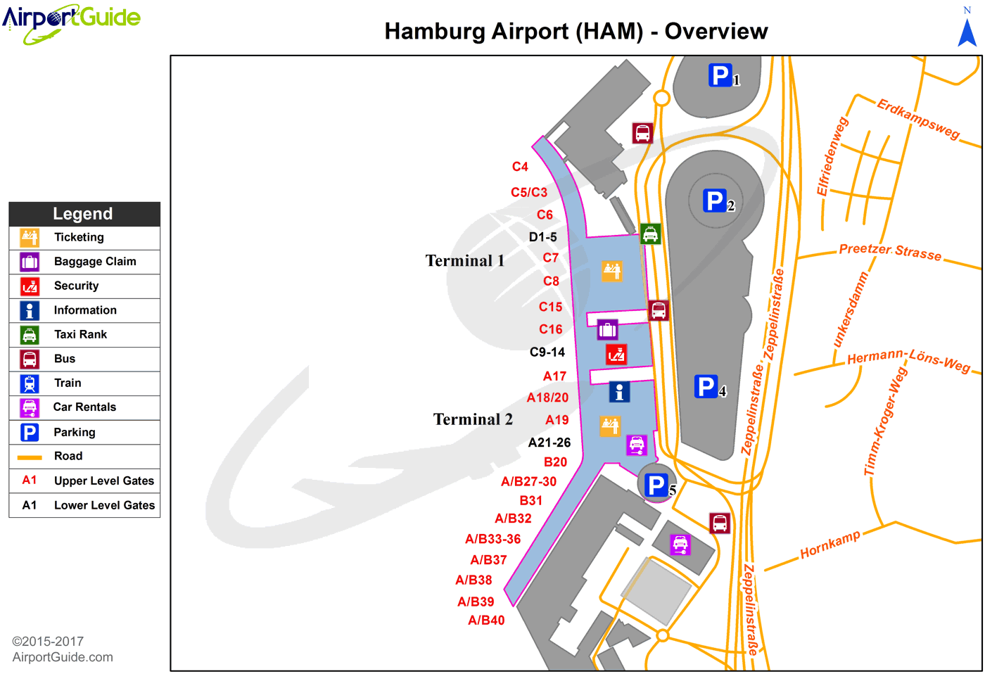
Maps & Diagrams
HAM Sectional
Flight Planning
at skyvector.com
at skyvector.com
