
Location
Latitude: |
46-59-27.9611N (46.9911) |
Longitude: |
015-26-22.56E (15.4396) |
Elevation: |
1115 feet MSL (340 m MSL) |
Magnetic Variation: |
4.9 E (as of April 2024 from WMM2020 model) |
Time Zone: |
UTC +1.0 (Standard Time) UTC +2.0 (Daylight Savings Time) |
Contacts
Manager: |
: |
Operations
Airport Status: |
Operational |
Facility Use: |
Public |
Type: |
Airport |
Traffic Pattern Altitude (MSL): |
2115 feet (645 m) |
Based Aircraft
Annual Operations (as of )
Communications
| TWR: | 118.2 |
| APP: | 119.3 |
| ATIS: | 126.125 |
Fixed Based Operators (FBOs) & Fuel
(Click on a business for detail)
Please help us keep this information up to date. This is a FREE SERVICE just like everything else on Airport Guide! If you see that a business needs to be added, modified, or deleted please fill out our Update Form.
To add, modify, or delete a business click here.
Please help us keep this information up to date. This is a FREE SERVICE just like everything else on Airport Guide! If you see that a business needs to be added, modified, or deleted please fill out our Update Form.
| Business Name | Frequency | Phone | Fuel Grade |
|---|
Flight Service Stations
| Primary | Alternate | |
| FSS on Field: | ||
| FSS Name (ID): | ||
| Frequency: | ||
| Toll Free Phone: |
Instrument Procedures / Charts
Terminal Procedures are only available for airports in several countries with more being added all the time. If you are looking for a specific country's charts, please send an email to support(at)airportguide.com stating the country name. This will be used to prioritize the implementation.
Navigation Aids (Navaids) near GRZ
| Dist (NM) | ID | Morse Code | Name | Type | Freq | True Hdg | Mag Hdg |
|---|---|---|---|---|---|---|---|
| 2.2 | GRZ | Graz | VOR-DME | 116.20 | 169 | 164 | |
| 4.3 | GRZ | Graz | NDB | 290 | 169 | 164 | |
| 16.0 | GBG | Gleichenberg | NDB | 426 | 112 | 107 | |
| 30.5 | ZW | Zeltweg | NDB | 418 | 294 | 289 | |
| 33.5 | MI | Maribor | NDB | 355 | 161 | 156 | |
| 39.9 | MR | Maribor | NDB | 334 | 158 | 153 | |
| 43.1 | KFT | Klagenfurt | VOR-DME | 113.10 | 237 | 232 | |
| 43.2 | KFT | Klagenfurt | NDB | 374 | 239 | 234 | |
| 53.8 | KW | Klagenfurt | NDB | 405 | 249 | 244 | |
| 56.3 | VAR | Varazdin | NDB | 344 | 136 | 131 | |
| 60.9 | DOL | Dolsko | VOR-DME | 112.70 | 206 | 201 | |
| 61.1 | MG | Ljubljana | NDB | 296 | 216 | 211 | |
| 61.4 | TF | Wierner Neustadt East | NDB | 315 | 33 | 28 | |
| 61.8 | KAM | Dolsko | NDB | 328 | 210 | 205 | |
| 63.2 | SNU | Sollenau | VOR-DME | 115.50 | 32 | 27 | |
| 65.0 | VIW | Villach | VOR-DME | 112.90 | 254 | 249 | |
| 73.5 | SME | Sarmellek | NDB | 428 | 104 | 99 | |
| 74.7 | ZAG | Zagreb | NDB | 367 | 150 | 145 | |
| 74.9 | ZAG | Zagreb | VOR-DME | 113.70 | 151 | 146 | |
| 77.2 | SK | S.kKaljevec | NDB | 350 | 156 | 151 |
Nearby Airports with Fuel
| Dist (NM) | Name (Airport IDs) | True Hdg | Mag Hdg | Fuel Grade |
|---|
Notices to Airmen (NOTAMS)
Remarks
No remarks for this landing facility
Runways
Runway Summary
| Runways: | 16C/34C 16L/34R 16R/34L |
| Longest Runway: | 16C/34C is 9842 ft (3000 m) long |
| Runways with an Instrument Approach: |
GRZ Airport Runway Details
| Runway 16C/34C | 9842 ft x 148 ft (3000 m x 45 m) | |
| Runway Edge Lights: | Yes Intensity | |
Runway 16C |
Runway 34C |
|
Elevation: |
1115 | 1088 |
Latitude: |
47.00429916381 | 46.97779846191 |
Longitude: |
15.435999870300 | 15.443300247192 |
|
Runway True Alignment: |
164 | 344 |
Glide Path Angle: |
0.0 degrees | 0.0 degrees |
REIL: |
Yes | Yes |
Threshold Elevation: |
1115 | 1088 |
Displaced Threshold: |
853 |
| Runway 16L/34R | 2100 ft x 98 ft (640 m x 30 m) | |
Runway 16L |
Runway 34R |
|
Elevation: |
1093 | 1106 |
Latitude: |
46.99060058593 | 46.98500061035 |
Longitude: |
15.442600250244 | 15.444100379943 |
|
Runway True Alignment: |
169 | 349 |
Glide Path Angle: |
0.0 degrees | 0.0 degrees |
Threshold Elevation: |
1093 | 1106 |
| Runway 16R/34L | 2493 ft x 82 ft (760 m x 25 m) | |
Runway 16R |
Runway 34L |
|
Elevation: |
1112 | 1102 |
Latitude: |
46.99539947509 | 46.98870086669 |
Longitude: |
15.435099601745 | 15.436900138854 |
|
Runway True Alignment: |
169 | 349 |
Glide Path Angle: |
0.0 degrees | 0.0 degrees |
Threshold Elevation: |
1112 | 1102 |
Displaced Threshold: |
492 | 492 |
Services
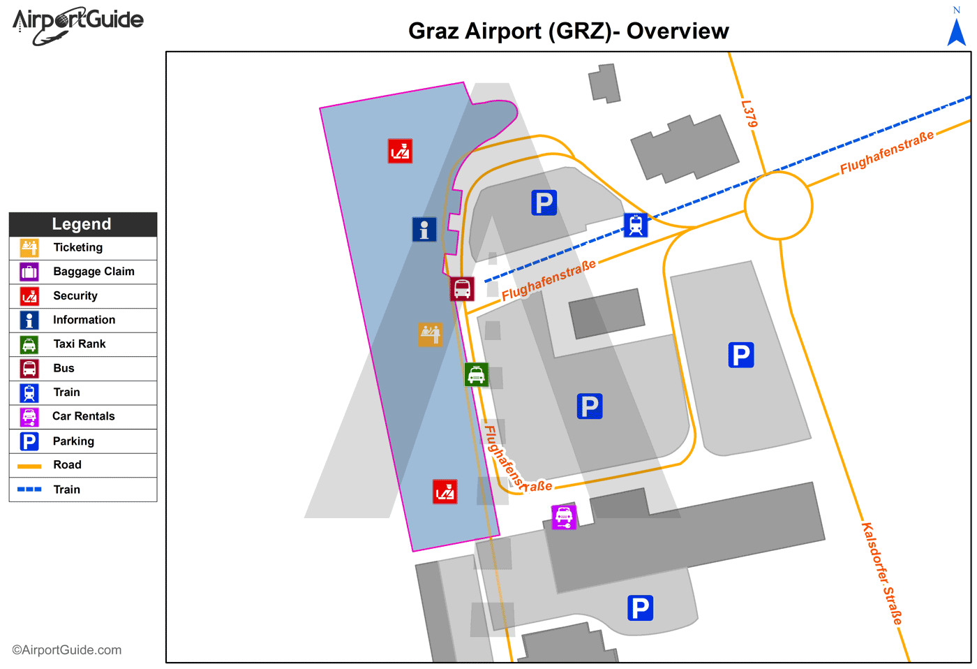
Maps & Diagrams
GRZ Sectional
Flight Planning
at skyvector.com
at skyvector.com
