Location
Latitude: |
37-55-39.1000N (37.927528) |
Longitude: |
100-43-27.9000W (-100.724417) |
Elevation: |
2890.8 feet MSL (881 m MSL) |
Magnetic Variation: |
5.2 E (as of April 2024 from WMM2020 model) |
Time Zone: |
UTC -6.0 (Standard Time) UTC -5.0 (Daylight Savings Time) |
From City: |
08 N.M. SE of Garden City, Kansas |
Found On: |
Wichita Chart |
FAA Region: |
ACE |
Contacts
Manager: |
Publicly owned: |
| MS. RACHELLE POWELL 2225 S. AIR SERVICE RD. 112 GARDEN CITY, KS 67846 620-276-1190 |
CITY OF GARDEN CITY CITY HALL, BOX 499 GARDEN CITY, KS 67846 620-276-1190 |
Operations
Airport Status: |
Operational |
Facility Use: |
Public |
Type: |
Airport |
Activation Date: |
02/1944 |
Control tower: |
Yes |
Attendance (Months/Days/Hours): |
Months/Days/Hours ALL/ALL/0700-2100 |
Boundary ARTCC: |
ZKC (Kansas City) |
Responsible ARTCC: |
ZKC (Kansas City) |
Lighting Schedule: |
SEE RMK |
Traffic Pattern Altitude (MSL): |
3891 feet (1186 m) |
NOTAMs Facility: |
GCK |
NOTAM-D Service: |
Yes |
International Airport of Entry: |
No |
Customs Landing Rights: |
No |
Military Landing Rights: |
Yes |
Civil/Military Joint Use: |
No |
Aircraft Rescue and Firefighting: |
Class I ARFF Index: A Air Carrier Service: Scheduled Certification Date: 05/1973 |
Based Aircraft
| Single Engine: | 58 |
| Multi Engine: | 7 |
| Jet Engine: | 4 |
| GA Helicopters: | 1 |
Annual Operations (as of 07/31/2023)
| Total Operations: | 15232 | |
| Commercial: | 482 | 3.2% |
| Air Taxi: | 2749 | 18.0% |
| GA Local: | 1716 | 11.3% |
| GA Itinerant: | 8805 | 57.8% |
| Military Aircraft: | 1480 | 9.7% |
Communications
| CTAF: | 118.150 |
| Unicom: | 122.950 |
| Tower: | GARDEN CITY 118.15 254.4 Hrs: 0700-2100 |
| Ground: | 119.0 254.4 |
| Approach: | KANSAS CITY ARTCC |
| Departure: | KANSAS CITY ARTCC |
| ASOS: | 121.325 (620-275-0803) |
- APCH/DEP CTL SVC PRVDD BY KANSAS CITY ARTCC (ZKC) ON FREQS 125.2/285.425 (GARDEN CITY RCAG).
- ATCT OPERATED BY MIDWEST.
Fixed Based Operators (FBOs) & Fuel
(Click on a business for detail)
Please help us keep this information up to date. This is a FREE SERVICE just like everything else on Airport Guide! If you see that a business needs to be added, modified, or deleted please fill out our Update Form.
To add, modify, or delete a business click here.
Please help us keep this information up to date. This is a FREE SERVICE just like everything else on Airport Guide! If you see that a business needs to be added, modified, or deleted please fill out our Update Form.
Area Code: 620 |
| Business Name | Frequency | Phone | Fuel Grade |
|---|---|---|---|
| Central Plains Aviation, Inc.
Update FBO info |
Unicom 123.0 | 275-5055 | 100LL, Jet A, MOGAS |
Flight Service Stations
| Primary | Alternate | |
| FSS on Field: | N | |
| FSS Name (ID): | Wichita(ICT) | |
| Frequency: | ||
| Toll Free Phone: | 1-800-WX-BRIEF |
Instrument Procedures / Charts
FAA Terminal Procedures valid from 0901Z 03/21/24 to 0901Z 04/18/24.
There are various types of charts available for an airport. They are listed in the Page Type column. Here is a legend for those types:
APD - Airport Diagram
DP - Departure Procedure Charts
HOT - Hot Spots
IAP - Instrument Approach Procedure Charts
MIN - Minimums
STAR - Standard Terminal Arrival Charts
| Page Type | Page Name | Volume | Action Since Last Cycle |
|---|---|---|---|
| APD | AIRPORT DIAGRAM | NC-2 | |
| HOT | HOT SPOT | NC-2 | |
| IAP | ILS OR LOC RWY 35 | NC-2 | |
| IAP | RNAV (GPS) RWY 12 | NC-2 | |
| IAP | RNAV (GPS) RWY 17 | NC-2 | |
| IAP | RNAV (GPS) RWY 30 | NC-2 | |
| IAP | RNAV (GPS) RWY 35 | NC-2 | |
| IAP | VOR RWY 17 | NC-2 | |
| IAP | VOR RWY 35 | NC-2 | |
| IAP | VOR/DME RWY 12 | NC-2 | |
| IAP | VOR/DME RWY 17 | NC-2 | |
| IAP | VOR/DME RWY 30 | NC-2 | |
| MIN | ALTERNATE MINIMUMS | NC-2 | |
| MIN | TAKEOFF MINIMUMS | NC-2 |
Terminal Procedures are only available for airports in several countries with more being added all the time. If you are looking for a specific country's charts, please send an email to support(at)airportguide.com stating the country name. This will be used to prioritize the implementation.
Navigation Aids (Navaids) near GCK
| Dist (NM) | ID | Morse Code | Name | Type | Freq | True Hdg | Mag Hdg |
|---|---|---|---|---|---|---|---|
| 0.5 | GCK | _ _ . _ . _ . _ . _ | Garden City | VORTAC | 113.30 | 183 | 178 |
| 5.9 | GC | _ _ . _ . _ . | Pieve | NDB | 347 | 179 | 174 |
| 34.0 | TQK | _ _ _ . _ _ . _ | Scott City | NDB | 256 | 346 | 341 |
| 34.3 | DDC | _ . . _ . . _ . _ . | Dodge City | VORTAC | 108.20 | 97 | 92 |
| 36.4 | ULS | . . _ . _ . . . . . | Ulysses | NDB | 395 | 237 | 232 |
| 51.0 | JHN | . _ _ _ . . . . _ . | Bear Creek | NDB | 341 | 250 | 245 |
| 54.3 | LBL | . _ . . _ . . . . _ . . | Liberal | TACAN | 112.30 | 192 | 187 |
| 55.3 | HQG | . . . . _ _ . _ _ _ . | Hugoton | NDB | 365 | 214 | 209 |
| 58.8 | LB | . _ . . _ . . . | Panck | NDB | 383 | 190 | 185 |
| 71.2 | OEL | _ _ _ . . _ . . | Oakley | NDB | 380 | 356 | 351 |
| 78.4 | EHA | . . . . . . _ | Elkhart | NDB | 377 | 225 | 220 |
| 79.1 | LQR | . _ . . _ _ . _ . _ . | Larned | NDB | 296 | 77 | 72 |
| 82.2 | GUY | _ _ . . . _ _ . _ _ | Guymon | NDB | 275 | 207 | 202 |
| 82.7 | BFK | _ . . . . . _ . _ . _ | Buffalo | NDB | 215 | 140 | 135 |
| 83.2 | HLC | . . . . . _ . . _ . _ . | Hill City | VORTAC | 113.70 | 16 | 11 |
| 85.8 | HY | . . . . _ . _ _ | Nette | NDB | 374 | 53 | 48 |
| 87.7 | HYS | . . . . _ . _ _ . . . | Hays | VORTAC | 110.40 | 50 | 45 |
| 89.8 | HIL | . . . . . . . _ . . | Hilyn | NDB | 338 | 72 | 67 |
| 90.4 | GB | _ _ . _ . . . | Babsy | NDB | 419 | 76 | 71 |
| 90.9 | PYX | . _ _ . _ . _ _ _ . . _ | Perryton | NDB | 266 | 180 | 175 |
Nearby Airports with Fuel
Notices to Airmen (NOTAMS)
Remarks
| A110-1 | RY 35 DESIGNATED THE CALM WIND RY. |
| A110-2 | AIR CARRIER OPS ARE NOT AUTHORIZED IN EXCESS OF 15 MINUTES BEFORE OR AFTER SCHEDULED ARRIVAL/DEPARTURE TIMES WITHOUT PRIOR COORDINATION WITH AMGR AND CONFIRMATION THAT ARFF IS AVBL PRIOR TO LDNG OR TKOF. |
| A110-3 | IN THE EVENT OF AN AIR CARRIER DIVERSION OR OTHER IRREGULAR OPERATIONS EVENTS, AIRCRAFT OPERATORS SHOULD CONTACT AMGR 620-290-3810. FACILITY CONSTRAINTS INCLUDE: LACK OF INTERNATIONAL PASSENGER PROCESSING FACILITIES, LIMITED NUMBER OF PARKING POSITIONS AND LIMITED TERMINAL SPACE FOR PASSENGERS. |
| A110-4 | ATCT BLIND SPOT ON THE NORTH TWY A HOLD BAY. |
| A110-5 | FOR CD IF UNA TO CTC ON FSS FREQ, CTC KANSAS CITY ARTCC AT 913-254-8508. |
| A15 | EMAIL: RACHELLE.POWELL@GARDENCITYKS.US |
| A16 | FAX 620-276-1192 |
| A17 | FOR SVC AFTER HRS CALL 620-275-5055. |
| A26 | CLSD TO UNSKED ACR OPNS WITH MORE THAN 30 PSGR SEATS EXCP PPR 48 HRS CALL AMGR (620) 276-1190/(620) 290-3810. ARFF INDEX B PROVIDED. |
| A70-FUEL-10 | 0LL FOR MILITARY FUEL CALL 620-275-5055. |
| A81-APT | ACTVT MIRL RY 12/30 & HIRL RY 17/35; REIL RYS 17; 12; 30 & MALSR RY 35 - CTAF. PAPI RYS 12 & 30 AND VASI RYS 17 & 35 ON 24 HRS. |
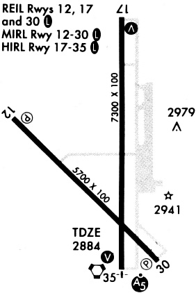
Runways
Runway Summary
| Runways: | 12/30 17/35 |
| Longest Runway: | 17/35 is 7299 ft (2225 m) long |
| Runways with an Instrument Approach: | 35 |
GCK Airport Runway Details
| Runway 12/30 | 5700 ft x 100 ft (1737 m x 30 m) | |
| Runway Length Source: | 3RD PARTY SURVEY as of 09/29/2011 | |
| Surface: | Concrete - Good condition - No special surface treatment | |
| Runway Pavement Class: | 35 /R/C/W/T | |
| Runway Edge Lights: | Medium Intensity | |
Runway Weight Bearing Capacity (in thousands of pounds) |
||
| Single Wheel Landing Gear: | 48.0 | |
| Dual Wheel Landing Gear: | 60.0 | |
Runway 12 |
Runway 30 |
|
Elevation: |
2890.7 | 2877.4 |
Latitude: |
37-55-51.2147N | 37-55-11.0815N |
Longitude: |
100-43-59.7942W | 100-43-09.8705W |
|
Runway True Alignment: |
135 | 315 |
Glide Path Angle: |
3.0 degrees | 3.0 degrees |
Traffic Pattern: |
Left | Left |
Runway Markings Type: |
Nonprecision Instrument | Nonprecision Instrument |
Runway Markings Condition: |
Good | Good |
Visual Glide Slope Indicators: |
2-Light PAPI On Left Side Of Runway | 2-Light PAPI On Left Side Of Runway |
REIL: |
Yes | Yes |
Threshold Crossing Height: |
47 | 46 |
Declared Distances |
||
Take Off Run Avbl. (TORA): |
5700 | 5700 |
Take Off Distance Avbl. (TODA): |
5700 | 5700 |
Actual Stop Dist. Avbl. (ASDA): |
5700 | 5700 |
Landing Dist. Avbl. (LDA): |
5700 | 5700 |
| Runway 17/35 | 7299 ft x 100 ft (2225 m x 30 m) | |
| Runway Length Source: | 3RD PARTY SURVEY as of 09/29/2011 | |
| Surface: | Concrete - Good condition - Saw-cut or plastic grooved | |
| Runway Pavement Class: | 38 /R/C/W/T | |
| Runway Edge Lights: | High Intensity | |
Runway Weight Bearing Capacity (in thousands of pounds) |
||
| Single Wheel Landing Gear: | 76.0 | |
| Dual Wheel Landing Gear: | 91.0 | |
| Dual Tandem Wheel Landing Gear: | 125.0 | |
Runway 17 |
Runway 35 |
|
Elevation: |
2888.6 | 2876.6 |
Latitude: |
37-56-21.2945N | 37-55-09.1448N |
Longitude: |
100-43-22.1524W | 100-43-22.8152W |
|
Runway True Alignment: |
180 | 000 |
ILS Type: |
ILS | |
Glide Path Angle: |
3.0 degrees | 3.0 degrees |
Traffic Pattern: |
Left | Left |
Runway Markings Type: |
Nonprecision Instrument | Precision Instrument |
Runway Markings Condition: |
Good | Good |
Visual Glide Slope Indicators: |
4-Box VASI On Left Side Of Runway | 4-Box VASI On Left Side Of Runway |
Approach Light System: |
1,400 Foot Medium Intensity Approach Lighting System With Runway Alignment Indicator Lights | |
REIL: |
Yes | |
Threshold Crossing Height: |
39 | 41 |
Declared Distances |
||
Take Off Run Avbl. (TORA): |
7299 | 7299 |
Take Off Distance Avbl. (TODA): |
7299 | 7299 |
Actual Stop Dist. Avbl. (ASDA): |
7299 | 7299 |
Landing Dist. Avbl. (LDA): |
7299 | 7299 |
Services
Airframe Repair: |
Major |
Powerplant Repair: |
Major |
Bottled Oxygen: |
None |
Bulk Oxygen: |
None |
Fuel Available: |
100LL, Jet A |
Landing Fees: |
No |
Parking: |
Hangars and tiedowns available |
Maps & Diagrams
GCK Sectional
Flight Planning
at skyvector.com
at skyvector.com