Location
Latitude: |
41-15-07.7000N (41.252139) |
Longitude: |
072-01-53.9000W (-72.031639) |
Elevation: |
7.2 feet MSL (2 m MSL) |
Magnetic Variation: |
13.5 W (as of April 2024 from WMM2020 model) |
Time Zone: |
UTC -5.0 (Standard Time) UTC -4.0 (Daylight Savings Time) |
From City: |
08 N.M. SE of Fishers Island, New York |
Found On: |
New York Chart |
FAA Region: |
AEA |
Contacts
Manager: |
Publicly owned: |
| DAVID MCCALL PO BOX 607, 261 TRUMBULL DR FISHERS ISLAND, NY 06390 917-675-0296 |
TOWN OF SOUTHOLD PO BOX 607 FISHERS ISLAND, NY 06390 631-765-1800 |
Operations
Airport Status: |
Operational |
Facility Use: |
Public |
Type: |
Airport |
Control tower: |
No |
Attendance (Months/Days/Hours): |
Months/Days/Hours MAY-OCT/SUN/1000-1630 |
Boundary ARTCC: |
ZBW (Boston) |
Responsible ARTCC: |
ZBW (Boston) |
Lighting Schedule: |
SEE RMK |
Segmented Circle Indicator: |
No |
Traffic Pattern Altitude (MSL): |
1007 feet (307 m) |
NOTAMs Facility: |
BDR |
NOTAM-D Service: |
Yes |
International Airport of Entry: |
No |
Customs Landing Rights: |
No |
Military Landing Rights: |
Yes |
Civil/Military Joint Use: |
No |
Based Aircraft
| Single Engine: | 2 |
Annual Operations (as of 06/03/2019)
| Total Operations: | 2125 | |
| Air Taxi: | 1100 | 51.8% |
| GA Local: | 500 | 23.5% |
| GA Itinerant: | 500 | 23.5% |
| Military Aircraft: | 25 | 1.2% |
Communications
| CTAF: | 122.800 |
| Unicom: | 122.800 |
| Approach: | PROVIDENCE 125.75 125.75 BOSTON ARTCC |
| Departure: | PROVIDENCE 125.75 125.75 BOSTON ARTCC |
- APCH/DEP SVC PRVDD BY BOSTON ARTCC ON FREQS 124.85/307.9 (WOODSTOCK RCAG) WHEN PROVIDENCE APCH CTL CLSD.
Fixed Based Operators (FBOs) & Fuel
(Click on a business for detail)
Please help us keep this information up to date. This is a FREE SERVICE just like everything else on Airport Guide! If you see that a business needs to be added, modified, or deleted please fill out our Update Form.
To add, modify, or delete a business click here.
Please help us keep this information up to date. This is a FREE SERVICE just like everything else on Airport Guide! If you see that a business needs to be added, modified, or deleted please fill out our Update Form.
Area Code: 631 |
| Business Name | Frequency | Phone | Fuel Grade |
|---|
Flight Service Stations
| Primary | Alternate | |
| FSS on Field: | N | |
| FSS Name (ID): | Bridgeport(BDR) | |
| Frequency: | ||
| Toll Free Phone: | 1-800-WX-BRIEF |
Instrument Procedures / Charts
FAA Terminal Procedures valid from 0901Z 03/21/24 to 0901Z 04/18/24.
There are various types of charts available for an airport. They are listed in the Page Type column. Here is a legend for those types:
APD - Airport Diagram
DP - Departure Procedure Charts
HOT - Hot Spots
IAP - Instrument Approach Procedure Charts
MIN - Minimums
STAR - Standard Terminal Arrival Charts
| Page Type | Page Name | Volume | Action Since Last Cycle |
|---|---|---|---|
| IAP | VOR OR GPS-A | NE-2 | |
| MIN | TAKEOFF MINIMUMS | NE-2 |
Terminal Procedures are only available for airports in several countries with more being added all the time. If you are looking for a specific country's charts, please send an email to support(at)airportguide.com stating the country name. This will be used to prioritize the implementation.
Navigation Aids (Navaids) near FID
| Dist (NM) | ID | Morse Code | Name | Type | Freq | True Hdg | Mag Hdg |
|---|---|---|---|---|---|---|---|
| 4.5 | GON | _ _ . _ _ _ _ . | Groton | VOT | 110.25 | 348 | 362 |
| 4.8 | GON | _ _ . _ _ _ _ . | Groton | VOR-DME | 110.85 | 348 | 362 |
| 18.3 | ORW | _ _ _ . _ . . _ _ | Norwich | VOR-DME | 110.00 | 4 | 18 |
| 21.2 | SEY | . . . . _ . _ _ | Sandy Point | VOR-DME | 117.80 | 103 | 117 |
| 23.8 | HTO | . . . . _ _ _ _ | Hampton | VORTAC | 113.60 | 212 | 225 |
| 30.0 | MAD | _ _ . _ _ . . | Madison | VOR-DME | 110.40 | 277 | 290 |
| 31.6 | FO | . . _ . _ _ _ | Squir | NDB | 400 | 228 | 241 |
| 32.9 | HFD | . . . . . . _ . _ . . | Hartford | VOR-DME | 114.90 | 315 | 328 |
| 36.8 | FOK | . . _ . _ _ _ _ . _ | Suffolk Co | TACAN | 111.00 | 227 | 240 |
| 38.5 | HVN | . . . . . . . _ _ . | New Haven | DME | 109.8 | 271 | 284 |
| 39.2 | PVD | . _ _ . . . . _ _ . . | Providence | VOR-DME | 115.60 | 43 | 57 |
| 39.2 | PVD | . _ _ . . . . _ _ . . | Providence | VOT | 108.20 | 43 | 57 |
| 39.7 | CCC | _ . _ . _ . _ . _ . _ . | Calverton | VOR-DME | 114.55 | 241 | 254 |
| 40.2 | HFD | . . . . . . _ . _ . . | Hartford | VOT | 108.20 | 316 | 329 |
| 43.0 | PUT | . _ _ . . . _ _ | Putnam | VOR-DME | 117.40 | 11 | 25 |
| 45.3 | AR | . _ . _ . | Armin | NDB | 356 | 42 | 56 |
| 49.3 | JWE | . _ _ _ . _ _ . | Clera | NDB | 362 | 279 | 292 |
| 49.6 | BDR | _ . . . _ . . . _ . | Bridgeport | VOR-DME | 108.80 | 264 | 277 |
| 49.7 | BDR | _ . . . _ . . . _ . | Bridgeport | VOT | 109.25 | 264 | 277 |
| 50.3 | BDL | _ . . . _ . . . _ . . | Bradley | VOT | 111.40 | 324 | 337 |
Nearby Airports with Fuel
Notices to Airmen (NOTAMS)
Remarks
| A110-1 | (A17) ARPT ATTENDED MAY-OCT MON THRU SAT 0800-1630; SUN 1000-1630; UNATNDD NOV-APR. |
| A110-3 | FOR CD CTC PROVIDENCE APCH AT 401-738-8945, WHEN APCH CLSD CTC BOSTON ARTCC AT 603-879-6859. |
| A16 | OR 860-460-7174 WHEN ATTENDED. |
| A52-07 | 24 FT DUNE. |
| A52-12 | RY 12, 2.5 FT SIGN POST 202 FT FM THLD 87 FT RT; 2.5 FT SIGN POS , 202 FT FM THLD 78 FT L. |
| A52-30 | RY 30, 5 FT ROCK SEAWALL 70-85 FT L PARALLEL TO RY. |
| A58-07 | RWY 07; 6 FT ROCK/GRAVEL DUNE PARALLEL TO RWY 75 FT R. 6 FT ROCK/GRAVEL DUNE 165 FT FROM RWY PERPENDICULAR TO RWY. |
| A58-12 | RWY12; +15FT RD PARALLEL TO RWY 90 FT L. |
| A58-25 | RWY 25; +7 FT BRUSH 170-180 FT FROM THLD 42-61 FT L. |
| A81-APT | ACTVT REIL RY 07/25 & RY 12/30; PAPI RY 07/25 & RY 12/30; MIRL RY 07/25 & RY 12/30 - CTAF. |
| E111 | APR 16, 1959 MIL FAC TURNED OVER TO COM. |
Runways
Runway Summary
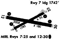
| Runways: | 07/25 12/30 |
| Longest Runway: | 12/30 is 2345 ft (715 m) long |
| Runways with an Instrument Approach: |
FID Airport Runway Details
| Runway 07/25 | 1806 ft x 75 ft (550 m x 23 m) | |
| Runway Length Source: | 3RD PARTY SURVEY as of 11/29/2018 | |
| Surface: | Asphalt - Fair condition - No special surface treatment | |
| Runway Edge Lights: | Medium Intensity | |
Runway 07 |
Runway 25 |
|
Elevation: |
4.3 | 7.2 |
Latitude: |
41-15-03.9597N | 41-15-12.5435N |
Longitude: |
072-02-04.5311W | 072-01-43.8088W |
|
Runway True Alignment: |
061 | 241 |
Glide Path Angle: |
3.8 degrees | 3.0 degrees |
Traffic Pattern: |
Left | Left |
Runway Markings Type: |
Basic | Basic |
Runway Markings Condition: |
Good | Good |
Object at End: |
GND | ROAD |
Object Height: |
30 | 10 |
Object Marked/Lighted?: |
Lighted | |
Distance from End: |
363 | 246 |
Object Centerline Offset: |
141 ft. left of centerline | 22 ft. right of centerline |
Visual Glide Slope Indicators: |
2-Light PAPI On Left Side Of Runway | 2-Light PAPI On Left Side Of Runway |
REIL: |
Yes | Yes |
Touchdown Lights: |
No | No |
Centerline Lights: |
No | No |
Threshold Crossing Height: |
20 | 20 |
| Runway 12/30 | 2345 ft x 100 ft (715 m x 30 m) | |
| Runway Length Source: | 3RD PARTY SURVEY as of 11/29/2018 | |
| Surface: | Asphalt - Fair condition - No special surface treatment | |
| Runway Edge Lights: | Medium Intensity | |
Runway 12 |
Runway 30 |
|
Elevation: |
6.7 | 3.9 |
Latitude: |
41-15-09.4332N | 41-15-05.0610N |
Longitude: |
072-02-08.7454W | 072-01-38.5998W |
|
Runway True Alignment: |
101 | 281 |
Glide Path Angle: |
3.0 degrees | 3.0 degrees |
Traffic Pattern: |
Left | Left |
Runway Markings Type: |
Basic | Basic |
Runway Markings Condition: |
Good | Good |
Object at End: |
ROAD | OTHER |
Object Height: |
15 | 5 |
Distance from End: |
200 | 200 |
Object Centerline Offset: |
141 ft. left of centerline | 22 ft. right of centerline |
Visual Glide Slope Indicators: |
2-Light PAPI On Left Side Of Runway | 2-Light PAPI On Right Side Of Runway |
REIL: |
Yes | Yes |
Touchdown Lights: |
No | No |
Centerline Lights: |
No | No |
Threshold Crossing Height: |
20 | 20 |
Services
Airframe Repair: |
Major |
Powerplant Repair: |
Major |
Bottled Oxygen: |
None |
Bulk Oxygen: |
None |
Fuel Available: |
100LL |
Landing Fees: |
No |
Parking: |
Hangars and tiedowns available |
Maps & Diagrams
FID Sectional
Flight Planning
at skyvector.com
at skyvector.com