Location
Latitude: |
34-21-07.5449N (34.352096) |
Longitude: |
098-59-02.0727W (-98.983909) |
Elevation: |
1258.0 feet MSL (383 m MSL) |
Magnetic Variation: |
4 E (as of April 2024 from WMM2020 model) |
Time Zone: |
UTC -6.0 (Standard Time) UTC -5.0 (Daylight Savings Time) |
From City: |
03 N.M. SE of Frederick, Oklahoma |
Found On: |
Dallas-Ft Worth Chart |
FAA Region: |
ASW |
Contacts
Manager: |
Publicly owned: |
| DONNIE COLEMAN CITY HALL PO BOX 399 FREDERICK, OK 73542 580-335-2421 |
CITY OF FREDERICK CITY HALL PO BOX 399 FREDERICK, OK 73542 580-335-7551 |
Operations
Airport Status: |
Operational |
Facility Use: |
Public |
Type: |
Airport |
Activation Date: |
07/1943 |
Control tower: |
No |
Attendance (Months/Days/Hours): |
Months/Days/Hours ALL/MON-SAT/0800-1700 |
Boundary ARTCC: |
ZFW (Fort Worth) |
Responsible ARTCC: |
ZFW (Fort Worth) |
Lighting Schedule: |
SEE RMK |
Segmented Circle Indicator: |
Yes |
Traffic Pattern Altitude (MSL): |
2258 feet (688 m) |
NOTAMs Facility: |
FDR |
NOTAM-D Service: |
Yes |
International Airport of Entry: |
No |
Customs Landing Rights: |
No |
Military Landing Rights: |
Yes |
Civil/Military Joint Use: |
No |
Based Aircraft
| Single Engine: | 10 |
| Multi Engine: | 2 |
| Military Aircraft: | 1 |
Annual Operations (as of 06/10/2022)
| Total Operations: | 63700 | |
| GA Local: | 1200 | 1.9% |
| GA Itinerant: | 2500 | 3.9% |
| Military Aircraft: | 60000 | 94.2% |
Communications
| CTAF: | 123.050 |
| Unicom: | 123.050 |
| Approach: | ALTUS 125.1 125.1 125.1 FORT WORTH ARTCC |
| Departure: | ALTUS 125.1 125.1 125.1 FORT WORTH ARTCC |
| ASOS: | 132.675 (580-335-7591) |
- ADVISORY SVC PRVDD TO CIVIL ACFT WHEN MILITARY USING ARPT FOR TRAINING.
- APCH/DEP CTL SVC PRVDD BY FORT WORTH ARTCC (ZFW) ON FREQS 128.4/269.375 (CLINTON-SHERMAN RCAG) & 133.5/350.35 (WICHITA FALLS NR 2 RCAG) WHEN ALTUS APCH CTL (LTS) CLSD.
Fixed Based Operators (FBOs) & Fuel
(Click on a business for detail)
Please help us keep this information up to date. This is a FREE SERVICE just like everything else on Airport Guide! If you see that a business needs to be added, modified, or deleted please fill out our Update Form.
To add, modify, or delete a business click here.
Please help us keep this information up to date. This is a FREE SERVICE just like everything else on Airport Guide! If you see that a business needs to be added, modified, or deleted please fill out our Update Form.
Area Code: 580 |
| Business Name | Frequency | Phone | Fuel Grade |
|---|
Flight Service Stations
| Primary | Alternate | |
| FSS on Field: | N | |
| FSS Name (ID): | Mc Alester(MLC) | |
| Frequency: | ||
| Toll Free Phone: | 1-800-WX-BRIEF |
Instrument Procedures / Charts
FAA Terminal Procedures valid from 0901Z 03/21/24 to 0901Z 04/18/24.
There are various types of charts available for an airport. They are listed in the Page Type column. Here is a legend for those types:
APD - Airport Diagram
DP - Departure Procedure Charts
HOT - Hot Spots
IAP - Instrument Approach Procedure Charts
MIN - Minimums
STAR - Standard Terminal Arrival Charts
| Page Type | Page Name | Volume | Action Since Last Cycle |
|---|---|---|---|
| IAP | RNAV (GPS) RWY 35 | SC-1 | |
| MIN | ALTERNATE MINIMUMS | SC-1 | |
| MIN | TAKEOFF MINIMUMS | SC-1 |
Terminal Procedures are only available for airports in several countries with more being added all the time. If you are looking for a specific country's charts, please send an email to support(at)airportguide.com stating the country name. This will be used to prioritize the implementation.
Navigation Aids (Navaids) near FDR
| Dist (NM) | ID | Morse Code | Name | Type | Freq | True Hdg | Mag Hdg |
|---|---|---|---|---|---|---|---|
| 23.4 | LTS | . _ . . _ . . . | Altus | VORTAC | 109.80 | 322 | 318 |
| 29.2 | SPS | . . . . _ _ . . . . | Wichita Falls | VORTAC | 112.70 | 138 | 134 |
| 29.5 | LAW | . _ . . . _ . _ _ | Lawton | VOR-DME | 116.85 | 72 | 68 |
| 31.1 | HBR | . . . . _ . . . . _ . | Hobart | VORTAC | 111.80 | 352 | 348 |
| 32.6 | PFL | . _ _ . . . _ . . _ . . | Post | NDB | 425 | 61 | 57 |
| 33.1 | SHP | . . . . . . . . _ _ . | Sheppard | TACAN | 110.80 | 131 | 127 |
| 37.3 | ICF | . . _ . _ . . . _ . | Madison | NDB | 296 | 135 | 131 |
| 38.6 | FSI | . . _ . . . . . . | Trail | FAN MARKER | 47 | 43 | |
| 38.6 | OFZ | _ _ _ . . _ . _ _ . . | Trail | NDB | 388 | 47 | 43 |
| 42.1 | SKB | . . . _ . _ _ . . . | Scotland | NDB | 344 | 144 | 140 |
| 52.9 | DUC | _ . . . . _ _ . _ . | Duncan | DME | 111 | 87 | 83 |
| 54.2 | BFV | _ . . . . . _ . . . . _ | Burns Flat | VORTAC | 110.00 | 348 | 344 |
| 64.6 | CDS | _ . _ . _ . . . . . | Childress | VORTAC | 117.00 | 271 | 267 |
| 66.8 | BZ | _ . . . _ _ . . | Fossi | NDB | 393 | 350 | 346 |
| 67.7 | SYO | . . . _ . _ _ _ _ _ | Sayre | VORTAC | 115.20 | 331 | 327 |
| 75.1 | GMZ | _ _ . _ _ _ _ . . | Grindstone Mountain | NDB | 356 | 126 | 122 |
| 75.2 | GHX | _ _ . . . . . _ . . _ | Graham | NDB | 371 | 161 | 157 |
| 75.5 | GTH | _ _ . _ . . . . | Guthrie | DME | 114.5 | 243 | 239 |
| 75.8 | UKW | . . _ _ . _ . _ _ | Bowie | VORTAC | 117.15 | 129 | 125 |
| 78.7 | AKL | . _ _ . _ . _ . . | Haskell | NDB | 407 | 207 | 203 |
Nearby Airports with Fuel
Notices to Airmen (NOTAMS)
Remarks
| A110-1 | ARPT USED AS SHEPPARD AFB AUX. MIL TFC DALGT MON-FRI; CTC UNICOM FOR ADZY. |
| A110-2 | MIL TFC ONLY WL USE RIGHT 360 DEG OVERHEAD APCHS TO RY 17. |
| A110-3 | FOR CD CTC FORT WORTH ARTCC AT 817-858-7584. |
| A32-03/21 | MKD TO 60 FT WIDE; PAVEMENT 150 FT WIDE. |
| A32-12/30 | RY MKD TO 75 FT WIDE; PAVEMENT 150 FT WIDE. |
| A33-03/21 | MODERATE CRACKING AND DETERIORATION. |
| A33-12/30 | MODERATE CRACKING AND DETERIORATION. |
| A70-FUEL-10 | 0LL SELF SER FUEL AVBL 24 HRS, FOR ASSISTANCE CALL 580-335-1948. |
| A81-APT | ACTVT MIRL RY 17/35 - CTAF. |
| E111 | PRE DATES THE ACT. |
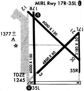
Runways
Runway Summary
| Runways: | 03/21 12/30 17/35 |
| Longest Runway: | 17/35 is 6099 ft (1859 m) long |
| Runways with an Instrument Approach: |
FDR Airport Runway Details
| Runway 03/21 | 4812 ft x 60 ft (1467 m x 18 m) | |
| Runway Length Source: | NGS as of 01/25/2008 | |
| Surface: | Concrete - Poor condition - No special surface treatment | |
Runway Weight Bearing Capacity (in thousands of pounds) |
||
| Single Wheel Landing Gear: | 30.0 | |
Runway 03 |
Runway 21 |
|
Elevation: |
1239.2 | 1253.0 |
Latitude: |
34-20-46.9644N | 34-21-20.5946N |
Longitude: |
098-59-18.3817W | 098-58-37.7712W |
|
Runway True Alignment: |
045 | 225 |
Glide Path Angle: |
0.0 degrees | 0.0 degrees |
Traffic Pattern: |
Left | Left |
Runway Markings Type: |
Basic | Basic |
Runway Markings Condition: |
Fair | Fair |
Object at End: |
ROAD | |
Object Height: |
15 | |
Distance from End: |
350 | |
Object Centerline Offset: |
250 ft. left of centerline |
| Runway 12/30 | 4578 ft x 75 ft (1395 m x 23 m) | |
| Runway Length Source: | NGS as of 01/25/2008 | |
| Surface: | Concrete - Poor condition - No special surface treatment | |
Runway Weight Bearing Capacity (in thousands of pounds) |
||
| Single Wheel Landing Gear: | 30.0 | |
Runway 12 |
Runway 30 |
|
Elevation: |
1255.9 | 1243.5 |
Latitude: |
34-21-30.0278N | 34-20-57.9846N |
Longitude: |
098-59-16.3717W | 098-58-37.7895W |
|
Runway True Alignment: |
135 | 315 |
Glide Path Angle: |
0.0 degrees | 0.0 degrees |
Traffic Pattern: |
Left | Left |
Runway Markings Type: |
Basic | Basic |
Runway Markings Condition: |
Fair | Fair |
Object at End: |
ROAD | |
Object Height: |
13 | |
Distance from End: |
350 | |
Object Centerline Offset: |
250 ft. left of centerline |
| Runway 17/35 | 6099 ft x 150 ft (1859 m x 46 m) | |
| Runway Length Source: | NGS as of 01/25/2008 | |
| Surface: | Concrete - Poor condition - No special surface treatment | |
| Runway Edge Lights: | Medium Intensity | |
Runway Weight Bearing Capacity (in thousands of pounds) |
||
| Single Wheel Landing Gear: | 35.0 | |
| Dual Wheel Landing Gear: | 50.0 | |
| Dual Tandem Wheel Landing Gear: | 100.0 | |
Runway 17 |
Runway 35 |
|
Elevation: |
1254.3 | 1236.1 |
Latitude: |
34-21-37.9970N | 34-20-37.6707N |
Longitude: |
098-59-21.6106W | 098-59-21.6656W |
|
Runway True Alignment: |
180 | 360 |
Glide Path Angle: |
3.1 degrees | 3.1 degrees |
Traffic Pattern: |
Left | Left |
Runway Markings Type: |
Nonprecision Instrument | Nonprecision Instrument |
Runway Markings Condition: |
Good | Good |
Object Centerline Offset: |
250 ft. left of centerline | |
Visual Glide Slope Indicators: |
4-Light PAPI On Left Side Of Runway | 4-Light PAPI On Right Side Of Runway |
Threshold Crossing Height: |
50 | 46 |
Services
Bottled Oxygen: |
None |
Bulk Oxygen: |
None |
Fuel Available: |
100LL, Jet A |
Landing Fees: |
No |
Parking: |
Hangars and tiedowns available |
Maps & Diagrams
FDR Sectional
Flight Planning
at skyvector.com
at skyvector.com